Integrated Sustainability Appraisal (ISA) Scoping Report
11. Landscape
11.1 This theme focuses on designated and protected landscapes within or near to Vale of Glamorgan, as well as landscape character, landscape quality and visual amenity.
Policy context
11.2 Table 11.1 presents the most relevant documents identified in the policy review for the purposes of the RLDP and ISA.
Table 11.1 Plans, policies and strategies reviewed in relation to landscape
Document title
Year of publication
2015
various
11.3 Key messages emerging from the review are summarised below:
- The RLDP will be required to be in general conformity with Future Wales, which sets out the 20-year spatial framework for land use, providing a context for the provision of new infrastructure / growth. The SDP for South East Wales will also seek to address regional factors such as housing, employment and infrastructure delivery, while giving great weight to conserving and enhancing protected landscapes, as well as landscape character and scenic beauty. Policy 19 within FW states that Strategic Development Plans should establish for the region "green corridors and nationally important landscapes". It will need to delineate the boundaries of the green belt that Future Wales makes provision for (Policy 34).
- PPW and supplementary TANs provide national planning policy in respect of landscape. PPW encourages effective and strategic placemaking, recognising that landscape and green infrastructure considerations are an integral part of the design process. PPW provides national policy on good design, and development plans and SPG should provide a clear context for design requirements in the local area.
- TAN 12 (Design) identifies 'character' as one of the five aspects of good design. Objectives in this respect include 'sustaining and enhancing local character', utilising design to respond to 'landscapes and townscapes' and 'locally distinctive patterns and forms of development'.
- The Placemaking Wales Charter builds on the strengthening focus on Placemaking in policy and practice in Wales and aims to provide a common understanding of the range of considerations that go into placemaking. The charter outlines the following six placemaking principles that cover the range of considerations that contribute to establishing and maintaining good places:
- People and community.
- Movement.
- Location.
- Public realm.
- Mix of uses; and
- Identity. - PPW and relevant TANs further highlight the importance of designated biodiversity sites, habitats, woodland, historic features, agricultural land and cultural landscapes. The positive contribution that land remediation can make in terms of addressing despoiled, degraded, derelict, contaminated and unstable land is also recognised.
Baseline summary
National Landscape Character Areas (NLCAs)
11.4 NLCAs are defined at a broad landscape scale throughout Wales. The descriptive profiles for the 48 individual character areas highlight what distinguishes one landscape from another, with reference to their regionally distinct natural, cultural and perceptual characteristics.[171]
11.5 Many environmental resilience and planning challenges are best considered at a 'landscape-scale'. The NLCA policy-neutral descriptions can contribute to the development of national and regional policy, strategy or guidelines.
11.6 The Vale falls with NLCA36 – Vale of Glamorgan (see Figure 11.1 below).
11.7 The summary description for the NLCA is:[172]
"The Vale is a distinctive, gentle lowland landscape, largely comprising a rolling limestone plateau. Glacial till contributes to its undulating topography. A variety of rural land uses characterise the area, reinforced by thick hedgerows, frequent small woodlands and trees, which create a sense of enclosure and intimacy. This is despite the proximity to large towns such as greater Cardiff, Barry and Bridgend, and a number of large built features within the Vale.
The landscape terminates abruptly at the heritage coast with vertical cliffs. There are a few sandy beaches, as well as shingle, but many images depict the exposed geology of the inter-tidal area, including bedding and pavements. There are long distance cliff top views towards Somerset. A notable feature affecting part of the coast is the large, modern, noisy, Aberthaw Power Station.
In the centre of the Vale, compact and historic settlements reinforce the area's distinctive sense of place, but with limited modern development. Yet the area has attracted many professionals, who commute to Cardiff and Bridgend, adding to the more prosperous character of places like Cowbridge and Llanblethian.
The area's historic character was shaped by Anglo-Norman influences. Norman castles and medieval villages centred on churches are key features. The registered landscape of Llancarfan is astoundingly beautiful as well as being a relatively unspoiled gem of historical evolution. All this is despite the relatively close proximity to nearby large towns."
11.8 The following key characteristics have been identified for the NLCA[173]:
- Lowland, rolling limestone plateau with glacial till.
- Coastal cliffs – mark a sudden edge to the landscape. Species-rich calcareous, neutral and maritime grasslands are found on their tops. Layers of geology characterise their sides and inter-tidal platforms. Wide views over the Bristol Channel. Much is Heritage Coast.
- Mixed agricultural land uses - with predominantly rural character.
- Small woodlands – mainly to the east. Few large woods.
- Mixed field patterns and sizes - with hedgerows and hedge banks, frequent hedgerow trees. Limestone walls define land above the cliffs in the west.
- Norman castles and medieval villages centred on churches.
- Predominantly still rural - with strong senses of enclosure by historic field boundaries.
- Several large built developments – including Cardiff International Airport and Aberthaw Power Station. Some areas with traffic noise, e.g., in the M4 corridor; and
- Commuter settlement - modern suburban housing extending but contrasting with historic settlement character.
11.9 In terms of the visual and sensory profile, the area forms a distinctive plateau landscape, dissected by several rivers including the Ely, Thaw and Waycock. It still evokes a strong rural sense of place with a patchwork of fields, hedgerows and woodlands and trees and extensive open, lowland, farmland.
11.10 The most iconic image is that of the Glamorgan Heritage Coast (see Chapter 10 above for further detail), where the otherwise gentle landscape comes to a very abrupt and dramatic edge, with near vertical cliffs in places, shingle or rock pavement beaches, and the occasional sandy bay to the west. From here there are long views across the Bristol Channel to Somerset and Exmoor. The coastal hinterland is typified by windblown vegetation that has resulted from the prevailing south-westerly wind exposure.
11.11 Further inland, the Bonvilston ridge forms a strong landscape element running across the centre of the Vale, reflected in views southwards across the Vale and northwards and into the South Wales Valleys.[174]
Local Landscape Character Areas (LLCAs)
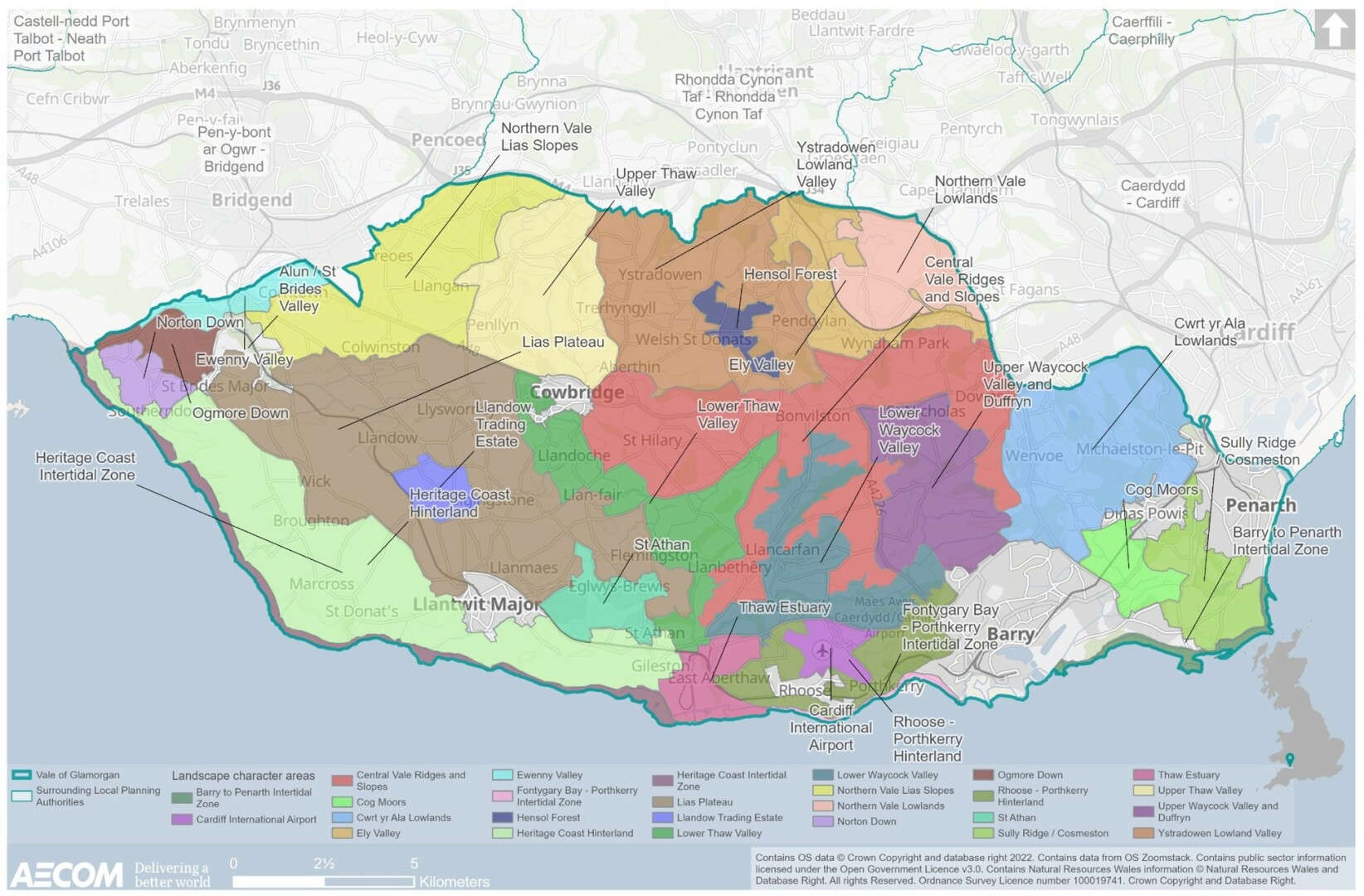
11.12 Figure 11.2 below shows the 27 Local Landscape Character Areas (LLCAs) within the Vale of Glamorgan.
Figure 11.1 National Landscape Character Areas
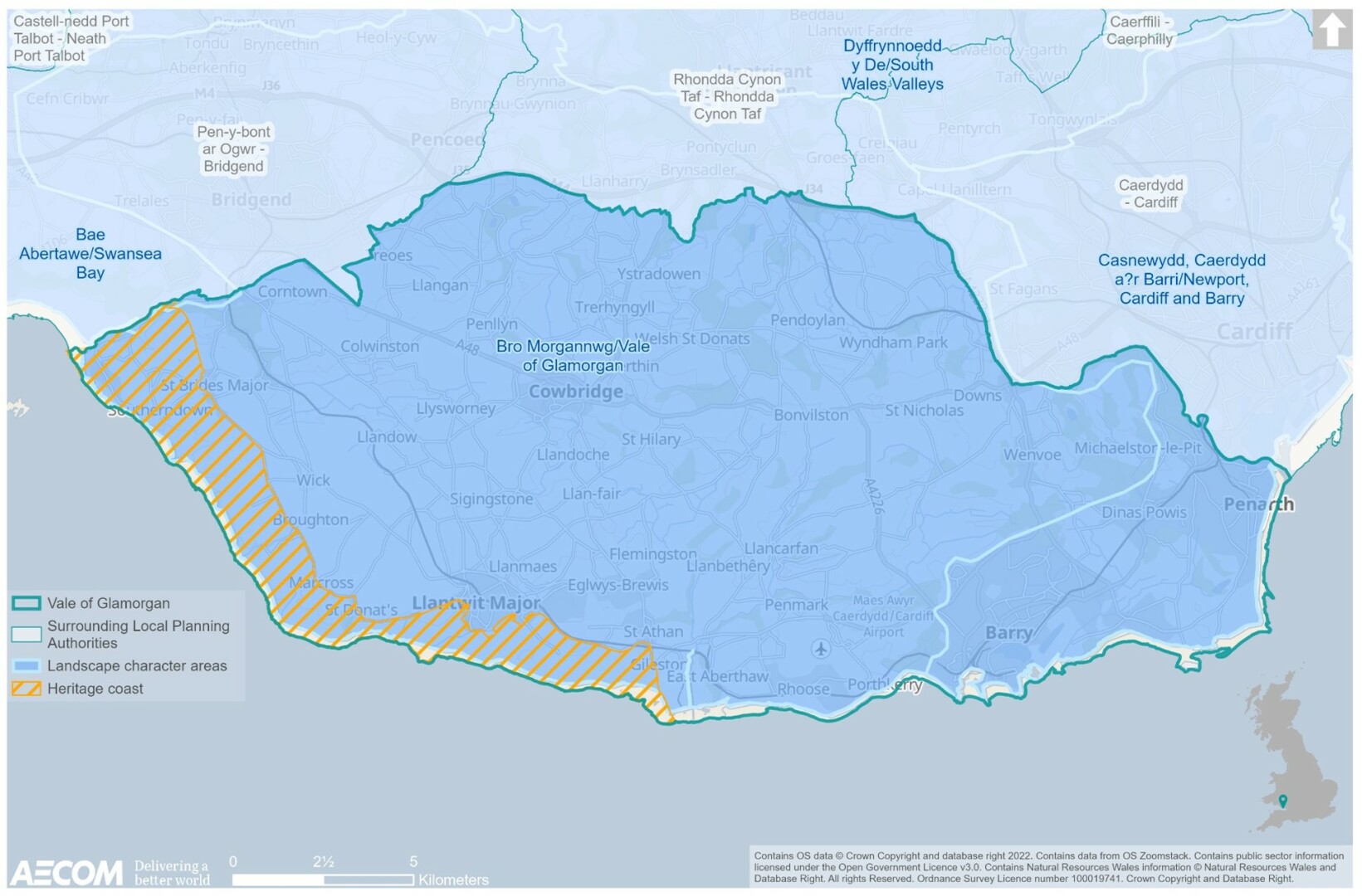
Figure 11.2 Local landscape character areas
Marine Character Areas (MCAs)
11.13 Seascapes, like landscapes, reflect the relationship between people and place and the part it plays in forming the setting to our everyday lives.
11.14 Marine Character Areas highlight the key natural, cultural and perceptual influences that make the character of each seascape distinct and unique. NRW were commissioned on behalf of Welsh Government to identify the character of Wales' seascapes at a broad scale. They divided Wales' inshore waters into 29 Marine Character Areas.[175]
11.15 The Vale of Glamorgan extends across two MCAs; the Severn Estuary MCA which is located east of the county borough, and the Glamorgan Coastal Waters and Nash Sands MCA which is located south/ south-west.
11.16 MCA 29 Severn Estuary comprises the Welsh part of the Severn Estuary, stretching from the national border with England to the western fringes of Barry.
11.17 The marine area is coincident with most of the Severn Estuary SAC (Wales) and full extent of the marine plan area. Its southwestern boundary broadly follows bathymetry, with the aim of excluding the deepest parts of the inshore channel.
11.18 The MCA also includes all of the Severn Estuary SPA, Ramsar and SSSI within the inshore and intertidal zones. It meets the coast in the west to be coincident with NLCA 35: Newport, Cardiff and Barry (developed coastline which spreads out from Cardiff Bay).
11.19 The MCA is also consistent with how the Estuary is spatially defined for the purposes of coastal navigation (e.g., Imray, 2008). The MCA excludes a small section of 'Welsh' waters along and at the mouth of the River Wye, which would be picked up by the adjacent English marine plan area.
11.20 Key characteristics include:[176]
- Expansive funnel-shaped Severn Estuary, sitting at the mouth of four major rivers (the Severn, Wye, Usk and Avon).
- The immense tidal range of the estuary is second only to the Bay of Fundy in Canada.
- The status of the tide has a significant bearing on perceived character.
- Soft Triassic and Jurassic rocks exposed along the shore, creating a wide rocky intertidal area. Elsewhere the shore is defined by extensive tidal flats.
- Mud, sand and gravel sediments deposited in the Holocene period producing a varied seabed of flats and bars, with associated shallow waters and numerous shoals presenting hazards to navigation.
- Flat Holm Island (SSSI and LNR) forms a gateway feature in the west – an outcrop of harder limestone rising out of the surrounding sediments. Steep Holm forms a similar 'twin' feature in English waters to the south.
- Estuary important for the interpretation of coastline dynamics and landforms, and past changes in sea level, sediment supply, climate and river flow.
- Strong tidal streams and turbidity producing biological communities characteristic of the extreme physical conditions of liquid mud and tide-swept sand and rock.
- Tidal flats, saltmarshes and the extensive wet grasslands are of international importance for wintering waterfowl and migratory birds.
- Some of the richest and most diverse populations of non-exploited fish in the UK – sea lamprey and twaite shad populations considered to be larger than in any other estuary.
- MCA's rich natural resources exploited by humans for millennia, with evidence dating back to the earliest hunter-gatherers roaming what was previously a much larger coastal plain (prior to sea level rise around 6,000 BC).
- Long-standing strategic importance for international trade and maritime navigation, particularly as ports on both sides of the Bristol Channel expanded from the medieval period onwards. Cardiff, Newport and Barry still retain important port functions.
- Numerous shipwrecks found on the sea floor, particularly in the west – including examples mined and sunk during WWII.
- Local trawlers catch plaice, turbot, whiting and rays from the MCA's sandbanks.
- Recreational charters and beach-based fishing are important economic activities.
- Salmon, eels and trout fished commercially and recreationally in the rivers feeding the estuary, including through the traditional method of putcher fishing (medieval intertidal fish traps are located at Goldcliff, West Pill and Caldicott).
- Flat coastline backed by the Wales Coastal Path, affording long views into the Bristol Channel.
- Estuary's classic funnel shape and south-west orientation make it susceptible to extreme weather conditions (including storm surges) sweeping in from the east Atlantic.
11.21 Glamorgan Coastal Waters and Nash Sands MCA covers the coastal waters directly to the south of the Vale of Glamorgan, adjacent to the sparsely settled south-facing coastline from Merthyr Mawr in the west to the outer fringes of Barry in the east.
11.22 The landward area encompasses all the Glamorgan Heritage Coast (the western landward boundary follows the line of the designation). Apart from Merthyr Mawr in the west (within the Heritage Coast designation), the landward extent complements the adjoining regional Landscape Character Area 36: Vale of Glamorgan (discussed above).
11.23 Offshore – in the west, the MCA takes in the full extent of Nash Sands to West Nash. It also includes Tusker Rock – a feature within the bay of Merthyr Mawr. The outer boundary with the Bristol Channel (MCA 28) is informed by the change to deeper water and large linear sand and gravel sediments associated with the Channel.
11.24 Key characteristics of this MCA are:[177]
- Dramatic ever-changing coastline of Jurassic and Triassic mudstones and limestone; with near vertical cliffs, shingle or rock pavement beaches, and occasional sandy bays.
- South and south-westerly aspect with gently shelving waters reaching a maximum of 18m bathymetry.
- Jurassic mudstone seabed overlain by bands of sand and gravel in the west, forming the distinctive linear Nash Sands with associated shoals, shallows and overfalls.
- Tusker Rock, an extensive reef, forms a key seascape feature in the west. It is exposed at low tide and surrounded by shallow waters.
- Strong tidal streams, high wave climate and exposure to winds funnelling up the Bristol Channel form further hazards to navigation.
- Sections of SSSI designated coastline nationally valued for species rich neutral, calcareous and maritime grassland. Dunraven Bay SAC is home to the rare shore dock.
- Internationally important habitats on Methyr Mawr Warren including sand dunes and slacks, saltmarsh, limestone grasslands and swamp habitats.
- Commercial trawling and rod and line fishing, the sand banks in the west being rich grounds for plaice, turbot, whiting and rays.
- Long history of human occupation, with Neolithic evidence beneath Merthyr Mawr, clifftop Iron Age hillforts and the remains of medieval castles, ports and ecclesiastical sites.
- The iconic 19th century Nash Point Lighthouse constructed of limestone from the beach below, guides ships past Nash Sands and is a symbol of the area's maritime heritage (the last manned lighthouse in Wales).
- Historic wrecks associated with the notorious Nash Point and Nash Sands, including 19th century sailing pilot cutters waiting to guide ships to Cardiff or Newport.
- Popular Heritage Coast-designated coastline, with the Heritage Coast Centre and Seawatch Centre drawing visitors to learn about the area's natural, cultural and maritime heritage.
- Often wild qualities of the area interrupted in the east by air traffic associated with Cardiff International Airport, and the dominating form of Aberthaw Power Station.
- Strong intervisibility with the Somerset coastline including Exmoor National Park and the Quantocks Area of Outstanding Natural Beauty (AONB).
- Views west along the coastline from Nash Point, including to the Gower AONB; and
- The area's expansive vistas are appreciated by users of the clifftop Wales Coast Path.
11.25 As shown in Figure 9.1 (in Chapter 9 above), the Severn Estuary MCA, SPA, Ramsar and SAC can be found at the eastern end of the Vale and is of international significance for overwintering birds.
11.26 The Glamorgan Coastal Waters and Nash Sands MCA comprises the coastal waters of the Glamorgan coastline, stretching from the expansive sand dune system of Merthyr Mawr in the west to the fringes of development at Barry in the east. The south and south-west facing coastline is a renowned Heritage Coast (see Chapter 10 above). The coastline is home to varied birdlife, including choughs, fulmars, bartailed godwits and peregrine falcons.
11.27 Cwm Nash displays a 12,000-year-old sequence of geological deposits containing abundant fossil snails – allowing for the reconstruction of climate change from the last glacial period until the present day.
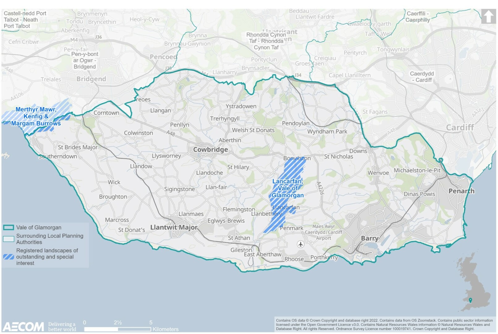
Registered Landscapes of Outstanding and Special Interest in Wales
11.28 The landscapes of Wales have been formed by natural processes and shaped by human activity. This human activity ranges from the prehistoric periods through to the modern age. To recognise the value of historic landscapes, and to raise awareness of their importance, Cadw, in partnership with the Countryside Council for Wales (now called Natural Resources Wales) and the International Council on Monuments and Sites (ICOMOS UK) has compiled a non-statutory Register of 58 landscapes of outstanding or special historic interest in Wales.[178]
11.29 The Register of Historic Landscapes is a non-statutory, advisory register. Its primary aim is to provide information and raise awareness of an initial selection of the most important and significant historic landscape areas in Wales in order to aid their protection and conservation.
11.30 Of the 58 registered landscapes there are two located within/ partially within the Vale. Llancarfan is located in the centre of the Vale, while Merthy Mawr is located to the north eastern extent of the Vale, along the revised LDP area boundary, extending into Bridgend (see Figure 11.3).
Figure 11.3 Registered Landscapes of Outstanding and Special Interest
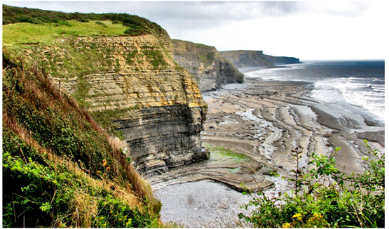
Glamorgan Heritage Coast
11.31 As set out in Chapter 9 above, while nationally recognised, Heritage coasts are 'defined' rather than designated. Heritage coasts are protected through development control within the planning system.
11.32 The Glamorgan Heritage Coast (see Figure 11.1 and Figure 11.4) is recognised for its national importance as an area of attractive undeveloped coastline, stretching for 14 miles, from Aberthaw to Porthcawl. The coast between Ogmore and Aberthaw is highly scenic, with a strong sense of place. Exposed limestone cliffs have extensive views over the Bristol Channel towards Somerset and Exmoor. Historic forts and lighthouses are features above the sandy beaches and rocky platforms. The often wild and open seascape, rocky shore and cliffs feel isolated in places.
11.33 The seascape has a generally southerly aspect, exposure to prevailing winds and gently shelving waters. This is combined with a build up to the high tidal range of the Severn Estuary, with the distinctive sandbank of Nash Sands and associated shoals and shallows.[179]
11.34 Farming is the foremost activity within the Heritage Coast, helping to maintain the landscape character and playing an important role in supporting the rural economy. The minor rural settlements of Ogmore and Southerndown fall within the designation and whilst being mindful of the need to protect the special qualities of the Glamorgan Heritage Coast.[180]
The Glamorgan Heritage Coast is also an important destination for visitors and offers opportunities for informal recreation, low impact tourism and coastal access, supporting walkers and cyclists (see Chapter 4).
Figure 11.4 Glamorgan Heritage Coast[181]
Special Landscape Areas
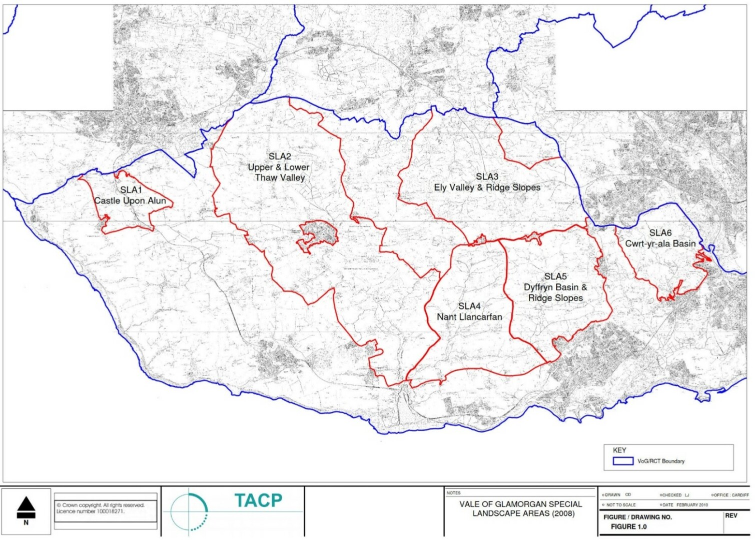
11.35 Special Landscape Areas (SLAs) are a non-statutory designation applied by the local planning authority to define areas of high landscape importance within their administrative boundary. SLAs in the Vale of Glamorgan have been designated to protect areas that are important for their geological, natural, visual, historic or cultural significance.[182]
11.36 SLAs were originally designated within the Vale based upon the Landscapes Working for Wales study in 1999. A review of the SLA designations, carried out in 2008 by TACP Consultants, identified six areas worthy of designation as SLAs. They closely followed the previous existing designated SLA's, with additional areas being included and some deleted, reflecting the updated information available. This revised methodology was devised by Natural Resources Wales in collaboration with a consortium of local authorities in South East Wales, using LANDMAP data.
11.37 The SLAs are listed below, shown in Figure 11.5, with further detail also provided in Table 11.2 below:[183]
- SLA 1 Castle Upon Alun.
- SLA 2 Upper & Lower Thaw Valley.
- SLA 3 Ely Valley & Ridge Slopes.
- SLA 4 Nant Llancarfan.
- SLA 5 Dyffryn Basin & Ridge Slopes; and
- SLA 6 Cwrt-yr-ala-Basin.
Figure 11.5 Special Landscape Areas[184]
|
SLA |
Need |
Primary landscape qualities/ features |
Relevant key policy and management issues |
Visual/ sensory evaluation (low, moderate, high, outstanding) |
|
Castle Upon Alun |
The area has very strong sense of place, in which context is strongly related to cultural identity. Coastal areas and river valleys are of outstanding quality in several aspects and include habitats for several rare species. The openness of this landscape makes it sensitive to development. |
On the western edge of the Vale and abutting the Heritage Coast boundary, large areas of this designation are of outstanding value in the visual, habitat, geological and sensory aspects. It is characterised by broad plateaus, gentle rolling hills and the Ewenny and Alun River valleys. Old Castle Down (SSSI) is an attractive and distinctive heath area, rare in the Vale and supporting important species. The Ogmore River provides a specific marsh landscape and dune system of international importance. |
Heath should be maintained, enhanced and enlarged Introduce blocks of broadleaved woodland to integrate settlement/ farm development and into stream valleys. Restrict development in widely visible areas and improve detailing to road approaches and settlement to reflect area character Reinforce screening to absorb development. |
Moderate to outstanding |
|
Upper & Lower Thaw Valley |
The Thaw Valley is of high value visually and culturally, has outstanding geological features and includes some areas of high habitat value. Suburban development is eroding the character, along with intensive agricultural practices and substitution of fences for hedgerows. |
The SLA is dissected by the Thaw River Valley. The generally open landscape has high intervisibility and overlooks Bridgend, bordering the M4, and colouring the perception of the area. The dramatic valley form has distinctive steep wooded slopes and a strong sense of place and is relatively uncommon. The rolling lowland landscape has views out to the coast. |
Maintain hedgerow and tree cover Improve development to ensure rural detailing and character Incorporate agri-environmental schemes Restrict development in widely visible areas and introduce blocks of broadleaf woodland to integrate settlement/ Ford related development. |
Moderate to high |
|
Ely Valley & Ridge Slopes |
The area surrounds the Ely Valley and adjacent major rail link. Areas are considered to be declining (pylons, the M4, A4232 and development along the A48, etc.) therefore designation would benefit future development. |
The area is predominately a lowland rolling landscape with the Ely River valley running through it from north to south-east. The majority of the lowland valley floor is flood plain, with a sense of openness that contrasts with the rising valley sides. Towards the east, enclosing the Ely floodplain, the landscape has an intact pastoral field patter and traditional settlement pattern. The M4 and A4232 are significant detractors by character is generally consistent with few areas affected by urban fringe and industry. Pylons in Ely Valley north detract from otherwise attractive views in and out of this area. Inappropriate development of farms into dwellings and poor land management are threatening the character integrity here. To the north-west the landscape is one of lowland valleys and hills. It is a well maintained landscape with a tranquil feeling. With strong hedgerow and woodland cover, it has high scenic but low habitat value. The southern boundary includes a ridge crest, prominent in the landscape and providing views across the Vale. The A48 bisects this ridge and linear settlements dominate. Hensol Forest to the west creates a landscape of uniform diversity with a sheltering, tranquil and safe feeling. The area is popular for recreation. |
Create links between fragmented woodland through new planting of green corridors Improve Hensol Forest as a focus for recreation and increase broadleaf colour Maintain coherence of field pattern and improve land management Manage priority habitat Control housing development and farm conversions Restrict development so it does not impinge on the ridge line and create linear development along the A48 |
Moderate to high |
|
Nant Llancarfan |
Nant Llancarfan valley identified as high and outstanding feature. The narrow and enclosed lowland Waycock Valley, with many villages designated as Conservation Areas, occupies the southern region of this SLA. Development to the southeast and the presence of Cardiff Airport is encroaching on this area. |
The majority of the area is rolling lowland, dissected by the Nant Llancarfan valley. This central area is steep sided, narrow lowland valley, with contains a tranquil and historic landscape of streams, semi-natural broadleaf woodlands, planted coniferous woodland and small farms. The ancient settlement of Llancarfan village stands within a Registered Landscape of Outstanding Historic Interest and contains a Conservation Area. The scattered rural/farm landscape is of outstanding value as being picturesque, for the preservation of historic communities. At the south, on the coastal plateau there are detractive views to Cardiff Airport hangar. This area is boundary to the steeper valley slopes and wooded edges of Waycock Valley, Penmark being a particularly picturesque village. |
Improve rural roads and restrict development to ensure rural detailing and character Remove power lines in Waycock Valley where possible Retain and enhance intrinsic character through woodland and hedgerow management and development restrictions. Maintain tree cover on ridgeline to the north to integrate development. |
Moderate to high |
|
Dyffryn Basin & Ridge Slopes |
Development including Wenvoe to the east and Barry to the south is eroding the otherwise fairly strong rural identity and integrity of the area |
The majority of the area is an attractive, gentle valley of the Nant Bran and River Waycock. There are broad, pleasing views to well-managed countryside which retains a coherent large field pattern and woodlands. It is a relatively unspoiled historic rural landscape and the area includes several BAPs. Settlements are well integrated with the landscape and surrounding vegetation. The combination of road, stream/ drainage ditch, stone wall/ garden or dwelling is typical and representative of the Vale in this area. Dyffryn Gardens, at the centre of the SLA, is discretely enclosed by woodlands. It is Grade 1 on the Register of Landscapes, Parks and Gardens of Special Historic Interest in Wales. The highest point to the east is a valley side by Wenvoe quarry. The Wenvoe area is a prime example of how landscapes have evolved over millenia. To the north, the area acts as a prominent sloping edge to the Ely and Wenvoe Valley. The area has a distinct sense of place. |
Reinforce rural character and minimise the impact of new development, restricting development on slopes in particular. Develop woodland cover and hedgerows to better integrate settlement Improve the road corridor and associated development, including detailing. Identify and implement solutions for infrastructure improvements at Dyffryn Gardens |
Moderate to high |
|
Cwrt-Yr-Ala-Basin |
This SLA is surrounded on three sides by large conurbation representing a significant threat through housing and infrastructure development. Its proximity to population also accounts for a large proportion of amenity grassland. |
The majority of the SLA area landscape is focused on the Cwrt-Yr-Ala valley, forming the headwaters of the Cadoxton Valley. There is a strong sense of place with streams, dammed ponds, wooded valley sides and pleasant settlement in the valley bottom. There are signs of urban pressures on lanes although farmland is generally well maintained. To the north and east a scarp slope acts as a western edge to Cardiff basin. The natural landscape has been significantly altered by urban expansion. There is an extensive area of current and former parks of Cwrt-Yr-Ala House. The SLA includes the open space of buffer between Penarth and Dinas Powys, which should be maintained for Binas Powys' character as one of few such large villages in SE Wales. The southeast boundary is Penarth which provided housing for dock workers in the 19th century. |
Manage woodland to maintain continuous tree cover, especially on the skyline. Maintain hedgerows as a strong visual framework and the rural qualities and vegetated nature of the valley. Maintain green wedge between Dinas Powys and Penarth, improve management of boundaries and improve structures. |
Low to high |
Future baseline
11.38 Given the extent of high quality, valued landscapes covering the Vale, new development within or within the setting of these high-quality areas (notably those areas locally or nationally designated/ recognised), will need to ensure that careful consideration is given to the design elements of the proposal. This includes the siting, orientation, layout and landscaping, to ensure that the special qualities and characteristics for which landscape areas have been designated are protected.
11.39 Without the RLDP, speculative development would continue to come forward with the potential for impacts on the landscape.
Key issues
11.40 The context review and baseline information informed the identification of several key issues (problems and opportunities):
- The Vale has a high quality, varied landscape, much of which is designated/ recognised nationally for its special qualities, and character including heritage and marine.
- The SLAs play an important contribution to the visual context and setting of settlements and have recreational value, while registered landscapes of special interest hold historic significance as well as landscape qualities. The Vale's coastal areas are of significant value, supporting a distinct and unique seascape. It will be important for the RDLP to ensure their long-term protection and enhancement of these assets.
ISA objectives
11.41 Considering the key issues discussed above, it is proposed that the ISA should include the following objective and assessment questions:
|
ISA objective |
Assessment questions – will the policy/proposal help to: |
|
To protect and enhance the quality and character of Vale of Glamorgan's landscape, seascape and townscapes. |
|
[171] Natural Resource Wales (2021): 'National Landscape Character Areas (NLCAs)', [online] available to access via this link
[172] Ibid
[173] Ibid
[174] Ibid
[177] Ibid
[178]Lle Geoportal for Wales (2022): 'The Registered Landscapes of Outstanding and of Special Interest in Wales', [online] available to access via this link
[179] Natural Resource Wales (no date): 'South Central Wales Landscape', [online] available to access via this link
[180] Vale of Glamorgan (2017): 'Adopted Local Development Plan', [online] available to access via this link
[181] Natural Resource Wales (2021): 'National Landscape Character Areas (NLCAs)', [online] available to access via this link
[182]TACP (2008): 'Vale of Glamorgan - Designation of Special Landscape Areas', [online] available to access via this link
[183] Ibid.
[184] Ibid