Integrated Sustainability Appraisal (ISA) Scoping Report
9. Biodiversity and geodiversity
9.1 This theme focuses on biodiversity and geodiversity interests within and surrounding Vale of Glamorgan.
Policy context
9.2 Table 9.1 presents the most relevant documents identified in the policy review for the purposes of the RLDP and ISA.
Table 9.1 Plans, policies and strategies reviewed in relation to biodiversity and geodiversity
Document title
Year of publication
2015
Vale of Glamorgan Biodiversity Forward Plan
2019
9.3 Key messages emerging from the review are summarised below:
- The Environment (Wales) Act introduced an enhanced biodiversity and resilience of ecosystems duty (Section 6 Duty). This duty applies to public authorities in the exercise of their functions in relation to Wales and will help maximize contributions to achieving the well-being goals. The Nature Recovery Plan supports this legislative requirement to reverse the decline in biodiversity, address the underlying causes of biodiversity loss by putting nature at the heart of decision-making and increasing the resilience of ecosystems by taking specific action focused around the six objectives for habitats and species.
- The RLDP will be required to be in general conformity with Future Wales, which sets out the 20-year spatial framework for land use, providing a context for the provision of new infrastructure/ growth. The SDP for South East Wales will also seek to address regional factors which include planning for biodiversity; in particular the conservation of wildlife and habitats. Promoting Vale of Glamorgan as a focus for growth will require careful management, protection, and enhancement of biodiversity, supporting the long-term resilience of ecosystems. Future Wales states that the planning system will ensure wildlife is able to thrive in healthy, diverse habitats, both in urban and rural areas, recognizing and valuing the multiple benefits to people and nature.
- PPW and supplementary TANs provide national planning policy in respect of biodiversity. PPW highlights the role of the planning system in helping to reverse the decline in biodiversity and increasing the resilience of ecosystems, at various scales, by ensuring appropriate mechanisms are in place to both protect against loss and to secure enhancement. Planning authorities must seek to maintain and enhance biodiversity in the exercise of their functions. This means development should not cause any significant loss of habitats or populations of species, locally or nationally and must provide a net benefit for biodiversity.
- TAN 5 (Nature Conservation and Planning) provides advice about how the land use planning system should contribute to protecting and enhancing biodiversity and geological conservation, notably setting out key principles of positive planning for nature conservation.
- The Vale of Glamorgan Biodiversity Forward Plan looks at how the Council manages and improves natural resources to ensure that biodiversity and sustainability issues are considered in all service areas and are core themes in service delivery, becoming an integral part of the decision-making processes throughout the Council. Part two of the Plan will translate into specific actions required to achieve objectives set out in Part 1 and give milestones and targets.
Baseline summary
Internationally designated sites
9.4 Internationally designated sites comprise Special Areas of Conservation (SAC), Special Protection Areas (SPA) and Ramsar Sites. The Vale of Glamorgan has two international designated sites within its administrative boundary: - Dunraven Bay (SAC) and Severn Estuary (SAC, SPA, Ramsar) and is directly adjacent to the Kenfig SAC in the county borough of Bridgend.
9.5 The locations of these sites are shown in Figure 9.1 at the end of this Chapter. Further details on each of these designated sites is presented below.
9.6 In the south of the Vale, the Severn Estuary SAC (also aRamsar wetland site of international importance), is an important area for wintering wildfowl and waders, and a Special Protection Area (SPA). The estuary also supports internationally important populations of migratory fish.
9.7 Annex I habitats and Annex II species that are a primary reason for designation of this site are:[158]
- 1130 Estuaries.
- 1140 Mudflats and sandflats not covered by seawater at low tide.
- 1330 Atlantic salt meadows Glauco-Puccinellietalia maritimae.
- 1095 Sea lamprey Petromyzon marinus.
- 1099 River lamprey Lampetra fluviatilis; and
- 1103 Twaite shad Alosa fallax.
9.8 Dunraven Bay SAC is part of Southerndown Site of Special Scientific Interest (SSSI) and is designated due to the presence of the rare shore dock, one of the rarest plants in Europe.
9.9 Annex II species '1441 Shore dock' is the primary reason for designation of this site. The 20 or so plants of shore dock (Rumex rupestris) growing here on damp coastal limestone are the only remnant of the species' former Bristol Channel range. The species has disappeared through loss of damp dune-slacks and shingle banks from other sites at Merthyr Mawr, Kenfig, Braunton Burrows and Pennard but is relatively secure on this steep, inaccessible site. The Dunraven Bay population is a significant seed-source for recolonisation of Bristol Channel dunes and beachheads when future management restores these habitats to favourable condition.[159]
9.10 While outside of the local authority boundary, it is noted that the Kenfig SAC is located within Bridgend County borough and lies adjacent to the Vale of Glamorgan. It is a largely intact dune system with extensive areas of fixed dune vegetation.
Annex I habitats and Annex II species that are a primary reason for designation of this site are:[160]
- 2130 Fixed coastal dunes with herbaceous vegetation ("grey dunes").
- 2170 Dunes with Salix repens ssp. argentea Salicion arenariae.
- 2190 Humid dune slacks.
- 3140 Hard oligo-mesotrophic waters with benthic vegetation of Chara spp.
- 1395 Petalwort Petalophyllum ralfsii; and
- 1903 Fen orchid Liparis loeselii.
Nationally designated sites
9.11 Nationally designated sites include Sites of Specific Scientific Interest (SSSIs). There are 28 SSSIs present across the county borough, as shown in in Figure 9.2, designated for their biodiversity or geodiversity interest, and totalling 941ha.
9.12 In descending size order, these are:
- Southerndown Coast (151 ha).
- Monknash Coast (129 ha).
- Coedydd y Barri / Barry Woodlands (120 ha).
- Old Castle Down (79 ha).
- East Aberthaw Coast (68 ha).
- Severn Estuary (64 ha).
- Ely Valley (59 ha).
- Penarth Coast (51 ha).
- Ewenny And Pant Quarries (29 ha).
- Hayes Point to Bendrick Rock (28 ha).
- Llynnoedd Cosmeston / Cosmeston Lakes (26 ha).
- Fferm Walters (25 ha).
- Nant Whitton Woodlands (22 ha).
- Barry Island (15 ha).
- Cliff Wood - Golden Stairs (13 ha).
- Cog Moors (13 ha).
- Cors Aberthin (12 ha).
- Sully Island (11 ha).
- Cwm Cydfin, Leckwith (5 ha).
- Clemenstone Meadows, Wick (5 ha).
- Pysgodlyn Mawr (4 ha).
- Breigam Moor (4 ha).
- Larks Meadows (3 ha).
- Coed y Bwl (2 ha).
- Cnap Twt (1 ha).
- Nash Lighthouse Meadow (1 ha); and
- The Parish Field, Cae'r Rhedyn (1 ha).
Ancient woodland
9.13 The Vale contains 1,568ha of Ancient Woodland, although this only covers 8.2% of the county which is well below the Wales average of 14%.[161] As shown in Figure 9.2 pockets of Ancient Woodland are located throughout the Vale. It is noted that some are designated as SSSIs and support populations of dormice; these woodlands are connected by the vast network of hedgerows in the authority. Woodlands cover 8.2% of the Vale of Glamorgan, which is well below the Wales average of 14%.
9.14 Natural Resource Wales manage 330ha of small mixed woodlands, mostly Plantations on Ancient Woodland Sites, on behalf of the Welsh Government. Many of the woodlands in the Vale have high conservation value and some offer formal and informal recreation opportunities (most are privately owned).[162]
9.15 All woodlands in South Wales are within a Control Disease Zone (CDZ) for Phytophthora ramorum (larch tree disease). Larch trees formed a high proportion of the forestry of the South Wales and their removal is having a noticeable effect on the biodiversity and landscape in many areas.
Heritage Coast
9.16 Heritage Coasts occupy about a third of the Welsh coastline, that is 500 km (300 miles). These sites were set up to protect our coastlines from insensitive developments. Most are defined simply by the coastline between two named points, however some have clearly defined inland boundaries.[163] The Vale includes 53 kilometres of coastline including 23 kilometres of Glamorgan Heritage Coast (see Chapter 10 for further details). The Glamorgan heritage coast is rich in wildlife, including wooded valleys and supporting a diverse range of species, including breeding birds.
Locally designated sites
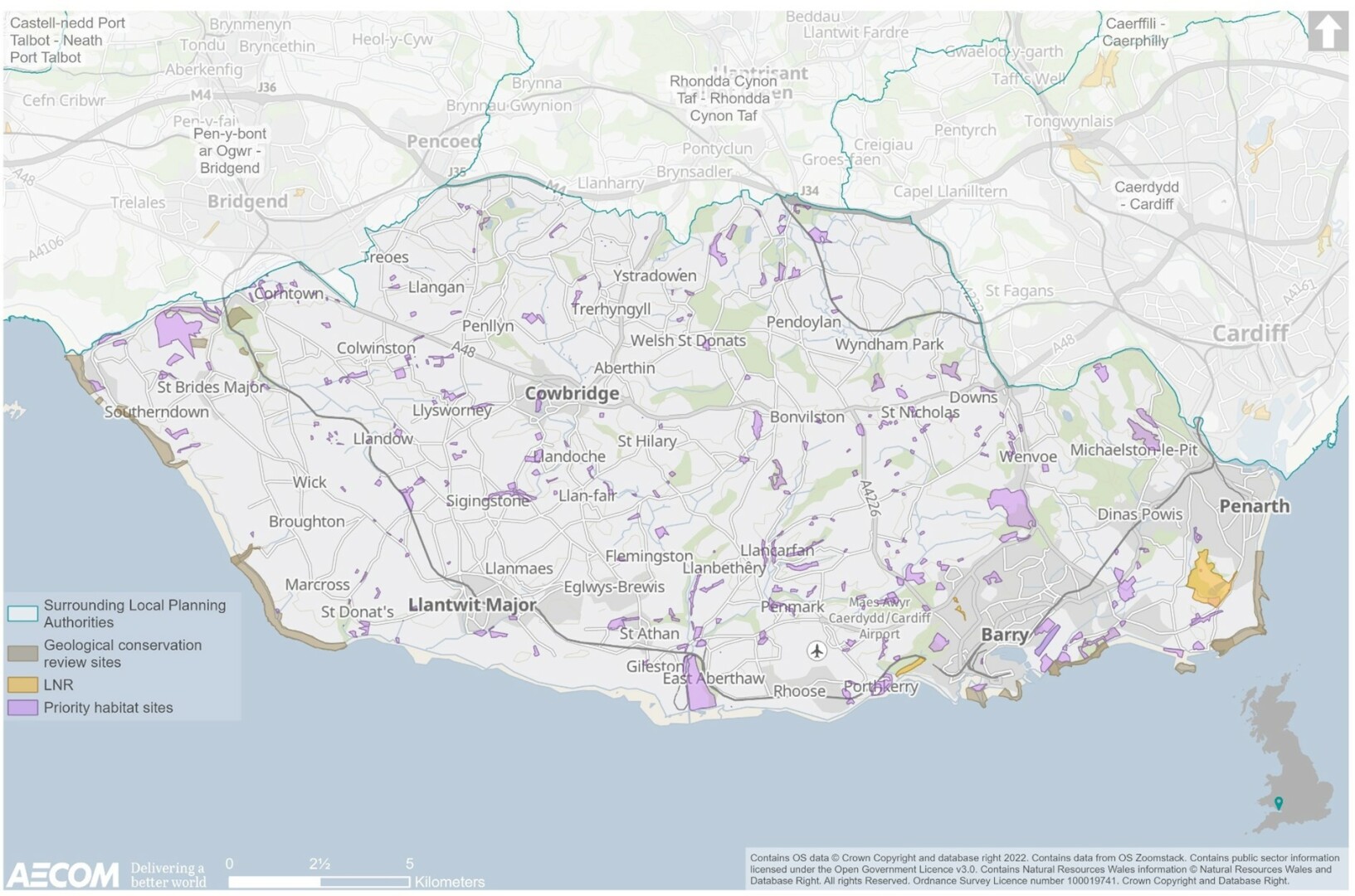
9.17 As shown in Figure 9.3 below, locally designated sites are present throughout the Vale.
9.18 Sites of Importance for Nature Conservation (SINCs) are identified to protect areas of high wildlife value at a local level. They are local authority planning designation relating to Policy MG33 of the adopted Local Development Plan (LDP) 2011-2026. There are approximately 360 SINCs scattered across theauthority as well as a number of candidate SINCs.[164]
9.19 Regionally Important Geological and Geomorphological Sites (RIGS) are locally designated sites of local, national and regional importance for geodiversity (geology and geomorphology). There are 12 RIGS including Sully Island and Wenvoe Quarry.
9.20 Local Nature Reserves (LNR) are owned or managed by the Vale of Glamorgan Council and there are currently three within its boundary, at Birchgrove Wood (Barry), Cliff Wood (Porthkerry), and Cwm Talwg (also Barry).
9.21 There are also seven Wildlife Trust Managed sites that cover approximately 93 hectares of land across the Vale. Additionally, there are two Woodland Trust Reserves in the Dinas Powys area, and two Country Parks at Comeston Lakes and Porthkerry (see Chapter 4). There is also over 500 hectares of common land.
Priority habitats and species
Species
9.22 Numerous species of biodiversity importance occur throughout the Vale of Glamorgan. The otter population and distribution has increased dramatically over from the 1960's and 1970's levels and is seen as a major conservation success story. The main reason for this increase has been the reduction in levels of toxic pesticides that were harmful to otters in the 1960s and 1970s, but the general improvements in water quality and consequent increase in fish stocks have probably played a significant part.
9.23 The European otter (Lutra lutra) is an important biological indicator of the health of rivers and wetlands. As a top predator monitoring the status of the otter gives a valuable measure of the state of our water and wetland ecosystems. Otters are present throughout the river systems of the Vale of Glamorgan, with particularly high levels of activity along the River Thaw and its tributaries.
9.24 The bullhead (Cottus gobio) occurs in the Vale of Glamorgan and is a small bottom-living fish that inhabits a variety of rivers, streams and stony lakes. It appears to favour fast-flowing, clear shallow water with a hard substrate (gravel/cobble/pebble) and is frequently found in the headwaters of upland streams. However, it also occurs in lowland situations on softer substrates so long as the water is well-oxygenated and there is sufficient cover. It is not found in badly polluted rivers.
9.25 Inland, the undulating managed grassland of the Alun Valley supports Wales' only population of the High Brown Fritillary butterfly.
9.26 Throughout the Vale, Great Crested Newt are widespread. The rich mosaic of habitat supports many bat species, particularly the Lesser Horseshoe Bat which has four known maternity roosts within the county. The Vale of Glamorgan also hosts a large maternity colony of Serotine Bat, a species uncommon in Wales. The large agricultural fields in the Vale are important for supporting populations of skylark and lapwing.
Habitats
9.27 Despite its relatively small area, the geology, coastal location, and land management of the Vale of Glamorgan results in a great variety of habitats. 19 of the key Biodiversity Action Plan (BAP) habitats for which costed habitat plans have been prepared can be found in the Vale (see Figure 9.3). Amongst these are habitats, which are relatively rare in Wales, such as mesotrophic lakes (as at Pysgodlyn Mawr) and saline lagoons (such as at Aberthaw).[165]
9.28 Whilst the extent of most of the key habitats (such as lowland heath, reedbeds, wet woodland) in the Vale of Glamorgan is small, relative to other authorities, it is likely that ancient and species-rich hedgerows in the area make up a significant percentage of the total for Wales. Similarly, as one of the main arable areas in Wales, the extent of cereal field margins is potentially significant.
9.29 Other locally important habitats in the Vale of Glamorgan contributing to the characteristic local biodiversity, or supporting key biodiversity species include: former quarries (providing habitats for birds of prey, butterflies, plants and lichens), road verges (relict grassland species and which, like disused railway lines, can act as wildlife corridors), waste ground (such as former dockland, which is attractive to some bird species for nesting, and may include rare plants, and parks and gardens.[166]
9.30 There are also several Highway Verge Conservation Zones within the County. These include a range of species-rich grassland types with associated ditches and hedgerows.
9.31 In addition to this, country parks managed for both wildlife and the public also contribute towards habitats.
Figure 9.1 International biodiversity designations
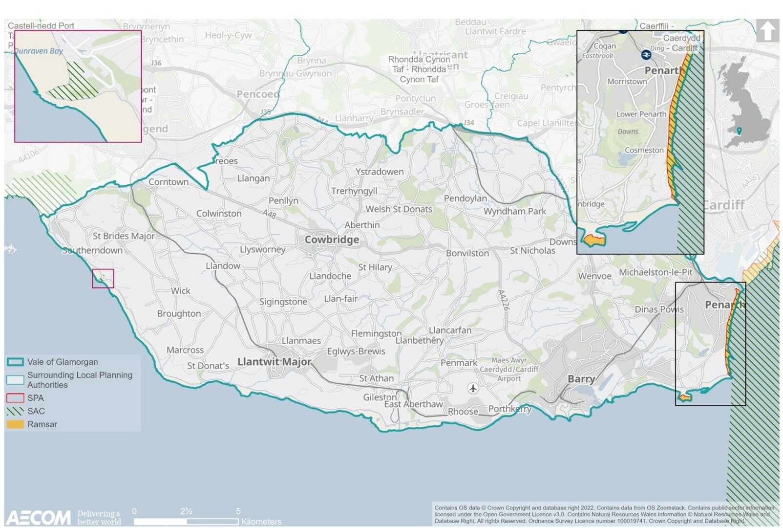
Figure 9.2 National biodiversity designations
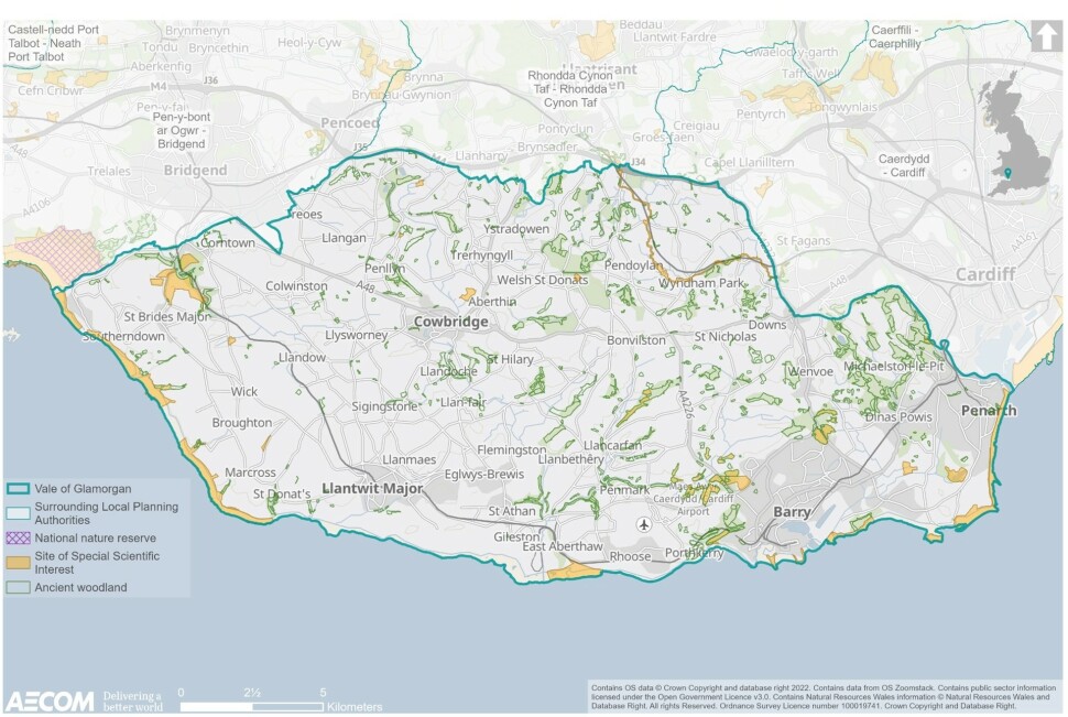
Figure 9.3 Local biodiversity designations and priority habitat
Future baseline
9.32 Habitats and species have the potential to come under increasing pressure from the provision of new housing, employment and infrastructure within and surrounding the plan area. This could include increased disturbance (recreational, noise and light) and atmospheric pollution as well as the loss of habitats and fragmentation of biodiversity networks. The loss and fragmentation of habitats will be exacerbated by the effects of climate change, which has the potential to lead to changes in the distribution and abundance of species and changes to the composition of habitats. This includes the loss of natural habitats or deterioration of their quality due to pressures as a result of coastal squeeze caused by erosion related to sea-level rises.
9.33 Benefits for biodiversity have the potential to arise from the increasing integration of biodiversity considerations within forward planning and efforts to protect and improve green infrastructure networks across the plan area, and regionally. To maintain and improve the condition of biodiversity in the future it will be important to not only protect and enhance important habitats but the connections between them.
9.34 Without the RLDP, speculative development would continue to come forward under the currently adopted LDP. The RLDP provides an opportunity to coordinate the delivery of growth to meet future needs, protect and minimise impacts on biodiversity and seek strategic opportunities to deliver biodiversity net gain where possible.
Key issues
9.35 The context review and baseline information informed the identification of several key issues (problems and opportunities):
- There are a vast number of designated sites for biodiversity within the county borough, including the Severn Estuary SPA, RAMSAR and SAC, Dunraven Bay SAC and the adjoining Merthyr Mawr National Nature Reserve, and 27 SSSIs. Locally, biodiversity assets include over 300 SINCs, 12 RIGS, and several LNRs. It will be important that any new development does not undermine the integrity of designated sites.
- There are many priority habitats and species present throughout the Vale. Priority habitats, urban and green spaces, coastal areas, and waterbodies all deliver ecological connectivity, supporting joined-up, connected places where biodiversity can thrive. It will be important for any new development to ensure that this ecological network is protected and enhanced both locally and sub-regionally.
- Future development should seek to maximise opportunities for biodiversity net gain, improving ecological links, protect and minimise harm from atmospheric pollution, where possible. In turn, this will bring positive effects for climate change adaptation, whilst tackling habitat fragmentation.
ISA objectives
9.36 Considering the key issues discussed above, it is proposed that the ISA should include the following objective and assessment questions:
ISA objectives
Assessment questions – will the option/proposal help to:
Protect and enhance biodiversity within and surrounding the Vale of Glamorgan.
- Minimise impacts on designated and important biodiversity features and provide net gains where possible?
- Protect and enhance ecological networks, including those that cross administrative boundaries?
- Support opportunities for green infrastructure, which have knock-on benefits for wildlife, connecting habitats and avoiding habitat fragmentation?
[161] Vale of Glamorgan Council (2019): 'Biodiversity Forward Plan', [online] available to access via this link
[162] Ibid.
[163] Lle (2021) Heritage Coasts [online] available at: https://lle.gov.wales/catalogue/item/ProtectedSitesHeritageCoast/?lang=en#:~:text=Heritage%20Coasts%20occupy%20about%20a,have%20clearly%20defined%20inland%20boundaries.
[164] Ibid
[165] Capita Symonds (2013): 'Vale of Glamorgan Flood Risk Management Strategy Volume 2 Strategic Environmental Assessment Report'
[166] Ibid