Integrated Sustainability Appraisal (ISA) Scoping Report
8. Natural resources (air, land, minerals and waste)
8.1 This theme focuses on local air quality, the quality of soil resources, waste generation, the extent of mineral resources, water supply resources and water quality in Vale of Glamorgan.
Policy context
8.2 Table 8.1 presents the most relevant documents identified in the policy review for the purposes of the RLDP and ISA.
Table 8.1 Plans, policies and strategies reviewed in relation to natural resources
Document title
Year of publication
2015
2019
8.3 Key messages emerging from the review are summarised below:
- The RLDP will be required to be in general conformity with Future Wales, which forms part of the development plan and sets out the 20-year spatial framework for land use, providing a context for the provision of new infrastructure/ growth. Future Wales identifies Vale of Glamorgan as falling within the South East Wales region, the smallest of the four regions by area, including the coastal cities of Cardiff and Newport and the former industrial heartlands of the south Wales valleys. The SDP for South East Wales seeks to address regional factors such as air quality, the water environment, land use, and the soil resource, recognising the wider benefits of natural capital and derived from ecosystem services.
- Furthermore, Future Wales recognises the need to take account of the long-term implications of climate change and build resilience in this respect, by guiding strategic development over the next 20 years. Future Wales encourages efficient land use, requiring that the relationships between all forms of land use and management be considered more fully if Wales is to address the climate emergency, reverse biodiversity decline and enable communities to benefit from more sustainable forms of managing natural resources. This is especially the case in large parts of the region's rural areas.
- The Environment (Wales) Act sets out the "sustainable management of natural resources" (SMNR); using natural resources in a way and at a rate that promotes the achievement of the objective to maintain and enhance the resilience of ecosystems and the benefits they provide. The Act sets out a framework for the delivery of SMNR, which includes practical steps to improve air quality, not just in the most polluted hotspots but across Wales.
- The Welsh Government has committed to taking a cross-government approach to tackling air quality. The 'Clean Air Wales' Programme (2018) seeks to reduce the burden of poor air quality on human health and the natural environment. This programme will consider evidence and develop and implement actions required across government departments including environment, health, education, decarbonisation, transport, local government, planning, agriculture, and industry to achieve clean air for Wales. The Programme will build on existing cross government work to reduce air pollution, including Future Wales and PPW.
- The Environmental Noise (Wales) Regulations 2006require the National Assembly for Wales to identify and publish details of noise sources. The competent authority must then produce strategic noise maps and action plans to deal with this noise pollution. Adding to this, TAN 11: Noise (1997) outlines how to use the planning system to reduce the adverse impact of noise. In 2015, an update to TAN 11: Noise was outlined.
- National planning policy is set out in PPW, the primary objective of which is to ensure that the planning system contributes towards the delivery of sustainable development, and contributes positively towards improving the social, economic, environmental, and cultural well-being of Wales. This is as required by the Planning (Wales) Act 2015, the Well-being of Future Generations (Wales) Act 2015 and other key legislation and resultant duties such as the Socio-economic Duty. In respect of natural resources, PPW requires that the preparation of LDP's takes account of the physical and environmental constraints on development of land, including, for example, the level of contamination and stability. Consideration should also be given to the potential impacts which remediation of land contamination might have upon the natural and historic environments.
- PPW also requires development plans to take water-related issues into account from an early stage in the process of identifying land for development and redevelopment. Allied to this, the Council, as a Sustainable Drainage Approval Body (SAB), has statutory responsibility for determining drainage applications in conjunction with new development.
- Air quality and soundscape are addressed in the PPW as a key component of the natural and built environment, placing the issues on an equal footing with other objectives such as housing, transport, and economic development. PPW recognises the importance of air quality and appropriate soundscapes to the health and well-being of people and the environment and seeks to ensure long-term approaches are taken to prevent creation of new problems or worsening of existing issues.
- With specific reference to waste management, TAN21 (Waste) states that land use planning should help to:
─ Drive the management of waste up the waste hierarchy and facilitate the provision of an adequate network of appropriate facilities.
─ Minimise the impact of waste management on the environment (natural and manmade) and human health through the appropriate location and type of facilities; and
─ Recognise and support the economic and social benefits that can be realised from the management of waste as a resource within Wales. - The Collections, Infrastructure and Markets Sector Plan (2012) 'Towards Zero Waste' is the overarching waste strategy document for Wales and covers the management of all waste in Wales and suggests where improved recycling is needed and aims to facilitate infrastructure developments to address the waste management capacity needs for Wales. For South East Wales, the plan identifies a requirement for additional waste management facilities capable of handling between 421,000 and 871,000 tonnes by 2024-2025.
- Regarding minerals, PPW stresses the importance of safeguarding deposits which society may need in the future. The RDLP should seek to safeguard the local resource in accordance with national policy to ensure availability for future generations. Specifically, PPW sets out a requirement for a steady and adequate supply of minerals. MTAN 1 (aggregates) and MTAN 2 (coal) further set a principle for the sustainable provision of resource to meet social needs for construction (aggregates) and energy (coal). The Regional Technical Statement 2nd Review sets the sub-regional and local context for minerals provision going forward, including local requirements for primary aggregates.
- PPW sets out that development plans are important vehicles for the promotion of environmental protection. They should enable consideration of the effects which proposed developments, and transport demand associated with them, may have on land, air, or water quality and the effects which land, air or water quality may have on proposed developments.
- Welsh Water's Water Resources Management Plan (WRMP) (2019) looks out across 30 years from 2020 to 2050 to assess potential risks to supplying sufficient water to meet anticipated demands. Key factors considered include demographic and economic changes that affect water demand, climate change which is recognised by WG's Future Generation's Act as a significant challenge facing Wales, and environmental obligations such as the European Water Framework Directive and the Habitats Directive.
- The Cardiff Capital Region and City Deal seeks to promote strong, sustainable, and balanced growth throughout the region, committing to a partnership approach to housing and regeneration, which encourages efficient land use, utilising brownfield land opportunities where possible. The deal aims to encourage investment and create an equal opportunity environment within the ten local authorities and other key partners in its boundaries. The RLDP should set out policies and proposals for the promotion of sustainable growth within the area that maximises resource efficiency and minimises environmental impacts.
- The recent adoption of the Vale of Glamorgan Recycling and Waste Management Business Plan and Strategy (2022 - 2032) is a key step towards addressing the Project Zero Challenge to "Reduce waste and put in place the necessary facilities, services and awareness raising for a more circular economy with a strong emphasis on reuse, repair and recycling". The Strategy considers our actions in the form of a 10-year plan (2022-2032) and aligns with WG priorities for recycling and waste.
Baseline summary
Air quality
8.4 There are currently no Air Quality Management Areas (AQMAs) in the Vale of Glamorgan; however, it is noted that Windsor Road, Cogan, Penarth AQMA was declared August 2013 for exceedances in nitrogen dioxide, but was revoked January 2021.[136]
8.5 Although air quality within the Vale of Glamorgan complies with regulations to protect human health and meets the relevant air quality objectives this will continue to be monitored as the Vale has one of the highest levels of man-made air pollution in Wales and is higher than the Welsh, Scottish and Northern Irish averages.[137] Air emission scores are much higher in the south and east of the county, including Barry, where population densities, traffic volumes and proximity to heavy industry are higher than in the more rural areas of the Vale of Glamorgan . Air emissions disproportionately affect the Vale's more deprived communities which can exacerbate already high levels of health inequality by increasing levels of respiratory disease and other illnesses.
Noise pollution
8.6 The quiet area map for Cardiff and Penarth[138] shows that there are five designated quiet areas in Penarth, which are:
- Penarth Head Lane
- Belle Vue Park
- Alexandra Park
- Golden Gates
- Victoria Playing Fields
8.7 Once an area has been designated as a quiet area, Planning Policy Wales requires development plan policies to have regard to the need to protect it from an increase in noise and requires special consideration where noise-generating development is proposed nearby[139].
Water resources
8.8 Natural Resources Wales (NRW) is responsible for managing water resources in Wales. One of the ways that this is done is through licensing water abstraction within catchment areas. NRW developed Catchment Abstraction Management Strategies (CAMS) to:
- inform the public on water resources and licensing practice.
- provide a consistent approach to local water resources management; and
- help to balance the needs of water-users and the environment.
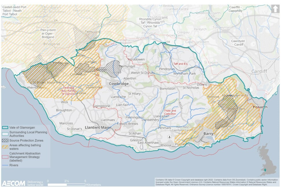
8.9 Two river catchment areas cover the authority with most of the area lying within the Cadoxton and Thaw CAMS area. A smaller area to the east lies within the Taff and Ely CAMS areas (both produced in 2006) (see Figure 8.2).
8.10 The largest potable water supply abstraction within the Cadoxton amd Thaw CAMS area is from Biglis Wells on the Cadoxton Moors. At low flow the River Cadoxton is currently identified as over-abstracted.[140]
8.11 Carboniferous Limestone is the main aquifer in the area and significant quantities of water can be abstracted from it. However, the limestone provides poor long-term storage and therefore provides little baseflow to the rivers. As a result, both river systems can experience naturally occurring low river flows during prolonged dry periods. In very dry summers, some of the smaller tributaries can dry up completely.[141]
8.12 Five Ground Water Source Protection Zones have been designated within the Vale of Glamorgan. These are shown within Figure 8.2, and are centred upon: Ogmore, Dinas Powys, Llansannor, Llangan and Treoes.
8.13 In terms of water quality, the Cadoxton and Thaw CAMS biological reports are either 'good' or 'very good' whilst the biological quality of the upper and lower stretches of the River Ely is good.
8.14 The Vale of Glamorgan lies within the Western Wales River Basin Management Plan (RBMP), with a small portion at the north of the authority being included within the Severn RBMP. The NRW's Local Authority Evidence Package for the Vale shows eight out of 14 surface water bodies shown to have Good Ecological Status (GES), five of Moderate Ecological Status and one at Poor Ecological Status.[142]
Bathing waters
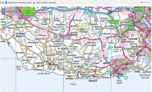
8.15 The Vale has four bathing beaches, these are Cold Knap Barry, Jackson's Bay, Whitmore Bay, and Southerndown.[143] Figure 8.1 shows the three bathing beaches in Barry to the east, and Southerndown bathing beach to the west of the Vale.[144]
Figure 8.1 Designated bathing water[145]
8.16 In Wales, Natural Resources Wales is responsible for monitoring bathing waters. Table 8.2 below shows that all four of the Vale's bathing beaches have passed the EC Bathing Waters classification from 2018. These results show that the overall water quality for Barry's Cold Knap and Southerndown has remained consistently high compared with the classification for Jackson Bay, which has more mixed results.
Table 8.2 Annual bathing water quality assessments[146]
Bathing water
2018
2019
2020
2021
Barry's Cold Knap
Excellent
Excellent
Excellent
Excellent
Whitmore
Good
Excellent
Good
Good
Jackson Bay
Sufficient
Good
Sufficient
Sufficient
Southerndown
Excellent
Excellent
Excellent
Excellent
8.17 The beaches and the coastal waters beyond are under pressure from a combination of diffuse rural pressures and urban pollution from sewage /misconnections in the developed areas. The top five sources of pollution are:[147]
- Pollution from sewage – bacteria from sewage can enter our waters because of system failures or overflows or directly from sewage works.
- Water draining from farms and farmland – manure from livestock or poorly stored slurry can wash into rivers and streams resulting in faecal material entering the sea.
- Animals and birds on or near beaches - dog, bird and other animal faeces can affect bathing water as they often contain high levels of bacteria (much higher than treated human waste).
- Water draining from populated areas - water draining from urban areas following heavy rain can contain pollution from a variety of sources, including animal and bird faeces.
- Domestic sewage – misconnected drains and poorly located and maintained septic tanks can pollute surface water systems.
Areas affecting bathing waters
8.18 Figure 8.2 shows areas affecting bathing waters within the Vale. This dataset comprises of polygons relating to each site identified under the Bathing Water Directive (76/160/EEC)/. Where a site corresponds to a Sensitive Area under the Urban Waste Water Treatment Directive (UWWTD) in England & Wales, the polygon for that Sensitive Area is provided. These areas coincide with the designated bathing waters discussed above.
Figure 8.2 Water resources and quality
Land and soil
Agricultural Land Classification (ALC)
8.19 Reflecting its the rural nature, approximately 85% (28,132 hectares) of the Vale is agricultural land. Post 1988 ALC surveys have been carried out for a small percentage of the Vale, as presented in Figure 8.3. There are areas of Grade 2 BMV agricultural land present to the east of Bonvilston and northwest of Llantwit Major.
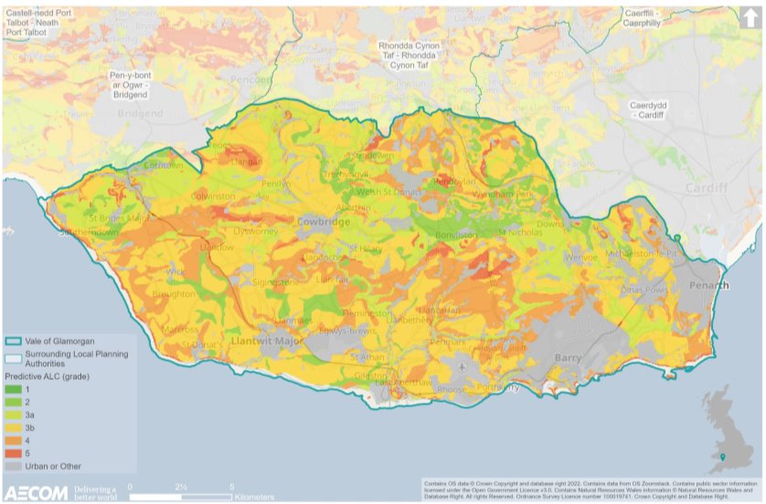
8.20 In light of limited post 1988 data, there is a need to rely on the predictive ALC mapping for the Vale (see Figure 8.4). Most agricultural land within the Vale of Glamorgan is classified as Grade 2 or Grade 3. There appear to be areas of high-quality agricultural land (Grade 1 and 2) to the north and central Vale, notably around Bonvilston, east of Cowbridge, and in the north eastern corner of the Vale around St Bridges Major and Corntown. However, it is recognised that this is predictive data, and a level of uncertainty therefore exists without full surveys being carried out.
8.21 It is worth noting that agricultural land, especially land that utilises farming methods such as conservation tillage, also acts as a carbon sink, storing carbon in the soil through sequestration. When land is disturbed, such as when it is developed for housing, carbon is released into the atmosphere, contributing towards climate change.
Figure 8.3 Post 1988 ALC
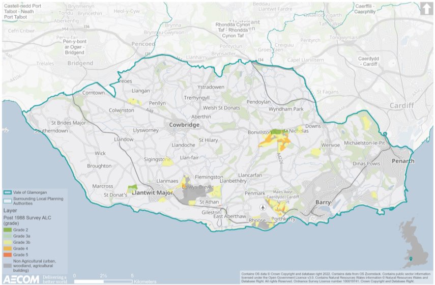
Figure 8.4 Predictive ALC
Minerals and geology
8.22 The Vale of Glamorgan is an important supplier of minerals and as the Minerals Planning Authority the Council has the responsibility for ensuring that the RLDP provides for a continued supply of minerals during and beyond the period covered by the RLDP. The assessment of the adequacy of the land bank is made in the light of guidance contained in MTAN1: Aggregates and in the South Wales Regional Technical Statement on Aggregates.[148]
8.23 Based on the Council's landbank reserve figure in July 2016 (31,962,000 tonnes), and the 10-year average production figure, the Vale of Glamorgan landbank for hard rock aggregate was 40.7 years giving a landbank of 30.7 years available at 2026. Reserves of hard rock for non-aggregate production (i.e. cement production) were identified as sufficient for 19.8 years supply.[149]
8.24 The Second Review of the RTS (September 2020) identifies that 16.806 million Tons (MT) of crushed rock is required over 25 years in the Vale of Glamorgan. The authority currently has 18.730MT of existing landbanks of permitted reserves for crushed rock meaning there is sufficient existing quantitative provision to meet the identified apportionment.[150]
Mineral working sites
8.25 As listed below and shown in Figure 8.5 below, the Vale includes several active minerals working sites:[151]
- Aberthaw – Liassic.
- Ewenny – Carboniferous.
- Forest Wood - Carboniferous (Shared with Rhondda Cynon Taf).
- Pant – Carboniferous.
- Pantyffynnon – Carboniferous.
- Longlands – Carboniferous.
- Lithalun – Carboniferous; and
- Wenvoe – Carboniferous.
8.26 The Vale also includes two inactive sites where future working is considered likely to occur. These sites are currently inactive but held in reserve:
- Garwa Farm – Carboniferous; and
- Ruthin – Carboniferous.
Dormant Mineral Sites
8.27 In addition to active quarry sites, there are several inactive and long dormant mineral sites within the Vale of Glamorgan where no mineral working has occurred for a period more than ten years. These are also shown within Figure 8.5 below, and identified as:[152]
- Beaupre (Long Grove) Quarry, St Hilary.
- Cnap Twt Quarry, Castle upon Alun.
- Cosmeston Quarry, Penarth.
- Cross Common Quarry, Dinas Powys.
- Downswood Quarry, Penarth.
- Ely Brickworks (site shared with Cardiff).
- Lavernock Quarry.
- St. Andrews Quarry, St Andrews Major; and
- Southerndown Road Quarry.
8.28 Many of the sites have regenerated naturally, have been put to alternative uses or are constrained by nearby development. For example, Cosmeston Quarry flooded to a depth of over 20 metres when quarrying ceased in the 1960s and has since been incorporated into Cosmeston Country Park; Lavernock Quarry and Southerndown Road have been used as waste disposal sites; and Ely Brickworks (shared with Cardiff) has been largely covered by the Ely Link Road.[153]
Figure 8.5 Mineral sites

Waste
8.29 As the Waste Planning Authority, the Council has a statutory responsibility for the collecting and disposing of Municipal (household) Waste and for land use planning control over waste management.
Recycling
8.30 Over 72% (72.3%) of household waste collected by the Council was prepared for reuse and/or recycled during the first half of 2020/21, this exceeds the statutory target of 64% for 2020/21.[154]
8.31 Additionally, during 2020/21, the Council landfilled a total 116 tons, which was the least by any Local Authority in Wales and represented a landfill rate of 0.2% compared with 1.13% from the previous year. The combined percentage of waste in Wales sent to Landfill was 4.85% which demonstrates the efficiency of the Vale's kerbside residual waste restrictions, communications and the use of energy recovery for waste.[155]
Recycling centres
8.32 At present the Council complies with its statutory duty by providing two Household Waste Recycling Centres (HWRC) located at the Atlantic Trading Estate in Barry (serving the Eastern area of the Vale of Glamorgan) and at the Llandow Trading Estate in Llandow (serving the Western area of the Vale of Glamorgan).[156] It is recognised that the site in Llandow urgently needs replacing.[157]
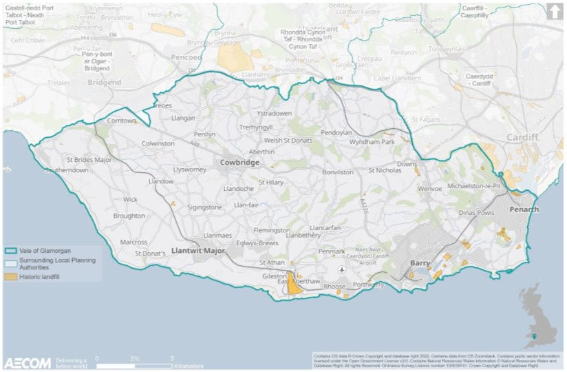
8.33 Regard should also be given to historic landfill sites in the Vale, which are focused predominately to the south of the authority (see Figure 8.6). The largest historic landfill site in the Vale is located east of Gileston / East Aberthaw.
Figure 8.6 Historic landfill sites
Future baseline
8.34 The acceleration of the roll out of electric vehicles (see Chapter 6 above) is likely to reduce issues relating to air pollution from motor vehicles in the long-term. Whilst some air pollution originates from sources aside from the combustion engine, such as that from industrial processes, this should help to reduce transport related air pollution issues in the long-term. However, the move towards a green economy and renewable energy, as well as reducing overall travel demand and encouraging active travel and public transport use, will also contribute towards improves in air quality in the future.
8.35 Water availability both within the Vale of Glamorgan and in the wider region has potential to be affected by projected growth and by an increased risk of drought because of climate change. Whilst Wales and more specifically the Vale of Glamorgan area is not anticipated to have issues relating to water resources, development has the potential to affect water quality through diffuse pollution, wastewater discharges, water run-off, and modification. Furthermore, pressures relating to climate and demographic changes alongside environmental obligations could place stresses upon aspects associated with water resourcing.
8.36 Recognising the significant extent of agricultural land present, future development in the Vale has the potential to result in the loss of best and most versatile agricultural land, particularly given that most agricultural land within the Vale of Glamorgan is classified as Grade 2 or Grade 3. Agricultural land, especially land that utilises farming methods such as conservation tillage, also acts as a carbon sink, storing carbon in the soil through sequestration. When land is disturbed, such as when it is developed for housing, carbon is released into the atmosphere, contributing towards climate change. As 85% of the Vale is covered by agricultural land, it will be difficult for development to be avoided here, however, mitigation measures can still be put in place to ensure soil disturbance is kept to a minimum.
8.37 The Vale is an important contributor to the provision of minerals regionally with numerous active sites throughout the authority. It will therefore be important for the RLDP to safeguard these sites and prevent further extraction of resources, as well as seek to ensure that restoration is undertaken where appropriate.
8.38 Regarding waste, at present the amount of household waste collected by the Council for reuse and/or recycling in the Vale exceeds the statutory target. In addition to this, the Vale has a relatively low level of waste entering landfill compared to other Local Authorities in Wales. It is therefore important for the RLDP to set out measures to maintain or reduce waste in the Vale.
Key issues
8.39 The context review and baseline information informed the identification of several key issues (problems and opportunities):
- Although there are no AQMAs present in the Vale, air emissions are higher in the south and east of the authority, including Barry. Emissions should be proactively managed and monitored through the forthcoming RLDP.
- Water quality in the Vale is generally good, including bathing waters.
- Five Ground Water Source Protection Zones are present in the Vale.
- Approximately 85% (28,132 hectares) of land within the Vale is agricultural land, much of which is Grade 2 or 3 and contributes towards belowground carbon storage.
- The Vale of Glamorgan is an important contributor to the regional supply of minerals and includes several active mineral sites.
- There are two recycling centres in the Vale and it is noted that the site in Llandow urgently needs replacing.
- When considering the above key issues, it is recognised that policy approaches are pushing towards a holistic and sustainable approach to the management, protection and use of natural resources, including through targeted measures to improve environmental outcomes relating to air quality, noise, soil, land, water and waste in order to maximise beneficial outcomes to social, environmental and economic factors.
- Policy reinforces the need to consider the interrelationship between planned developments and the factors mentioned above, with emphasis being placed on the likely effects of climate change, the need for efficient uses of land, resource use efficiency and conserving the natural environment.
ISA objectives
8.40 Considering the key issues discussed above, it is proposed that the ISA should include the following objective and assessment questions:
ISA objective
Assessment questions – will the option/proposal help to:
To identify and pursue any opportunities to reduce, or at least, minimise population exposure to air pollution.
- Reduce the need to travel?
- Encourage journeys to be made by sustainable means (active travel or public transport)?
- Avoid any adverse effects on air quality and for people exposed to poor air quality?
- Improve air quality in areas identified as of concern?
- Promote and facilitate the use of electric vehicles?
- Promote good design to avoid impacts on air quality and noise reduction and protects, incorporates and enhances green infrastructure networks to facilitate increased absorption and dissipation of NO2 and other pollutants?
To make the best use of previously developed land and existing buildings to minimise pressure for greenfield development and protecting, where possible, higher grade agricultural land.
- Minimise the loss of potentially high-grade agricultural land to developments?
- Protect and minimise loss of the soil resource and encourage appropriate management to enhance its carbon sequestration and water management functions?
- Encourage the use of previously developed land?
- Encourage development-related remediation works which could reduce the presence of contaminated land in Vale of Glamorgan?
To protect mineral resources and support waste management.
- Address waste by reducing and minimising waste as a priority?
- Manage waste in accordance with the waste hierarchy and in the context of 'Towards Zero Waste'?
- Avoid the sterilisation of mineral resources where possible?
To conserve, protect and enhance the water environment, water quality and water resources.
- Reduce water consumption?
- Ensure an adequate supply of water can be provided to sustain the development considering current and future projections of water availability and water use?
- Reduce the potential for contamination of waterbodies and courses?
- Reduce the potential for agricultural practices to contribute towards nitrate-based pollution of waterbodies and courses?
[136] Defra (2022): 'List of Local Authorities with AQMAs', [online] available to access via this link
[137] Vale of Glamorgan Public Service Board (2018): 'Our Vale – Our Future', [online] available to access via this link
[138] Welsh Government (2013): 'Quiet area map: Cardiff and Penarth', [online] available to access via this link
[139] Welsh Government (2012): 'Written Statement – Written statement on the designation of the first tranche of urban quiet areas under the Environmental Noise Directive', [online] available to access via this link
[140] Vale of Glamorgan (no date): 'Our Environment Evidence Report', [online] available to access via this link
[141] Ibid
[142] Ibid
[143] Ibid
[144] Natural Resource Wales (2021): 'Find a bathing water', [online] available to access via this link
[145] Ibid.
[146] Natural Resource Wales (2021): '2020 Bathing Water Profile for Whitmore Bay Barry Island', [online] available to access via this link
[147] Ibid
[148] Welsh Government (2018): 'Minerals Planning Policy – Aggregates', [online] available to access via this link
[149] Ibid.
[150] Regional Technical Statements for the North Wales and South Wales Regional Aggregate Working Parties – 2nd Review, September 2020
[151] Vale of Glamorgan Council (2017): 'Adopted Local Development Plan', [online] available to access via this link
[152] Ibid
[153] Ibid
[154] Ibid
[155] Vale of Glamorgan (2022): 'Recycling and Waste Business Plan and Strategy', [online] available to access via this link
[156] Vale of Glamorgan Council (no date): 'Household Waste Recycling Centres', [online] available to access via this link
[157] Ibid