Housing Growth in Barry
Atodiadau
Atodiad 1 - Mapiau o Safleoedd a Ddygwyd Ymlaen
Safleoedd wedi'u cario ymlaen
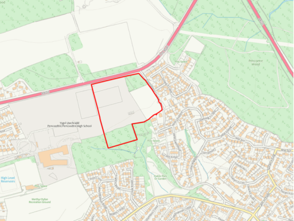
Tir ym Mhencoedtre
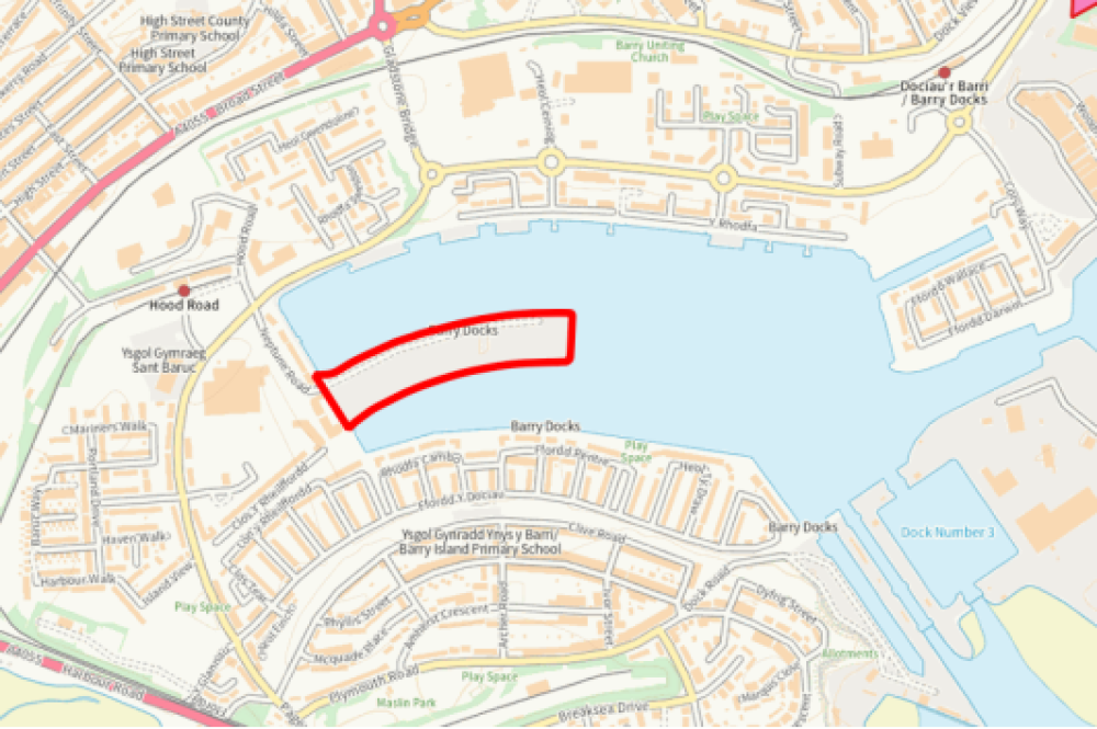
Tir yn y Mole, Glannau'r Barri
Atodiad 2 - Safleoedd ymgeisiol tai neu dai'n bennaf yn ardal y Barri
Galwad gyntaf am safleoedd
|
Cyfeirnod Safle |
Enw'r Safle |
Nifer anheddau posib |
Statws ar gam y Strategaeth a Ffefrir |
Casgliad ar gam y strategaeth a ffefrir |
|
371 |
Fferm Walter |
240 |
Ddim yn addas i'w ystyried ymhellach |
Byddai datblygu'r safle yn cael effaith negyddol sylweddol ar safle o bwysigrwydd ceidwadaeth natur (SoBCN) dynodedig lleol ac yn cael effaith niweidiol ar rywogaethau, cynefinoedd, cerrig camu neu goridorau bywyd gwyllt gwarchodedig/blaenoriaeth. Nid yw'r safle wedi'i gysylltu'n dda â'r ffurf adeiledig bresennol a byddai'n cynrychioli datblygiad gwasgaredig yng nghefn gwlad. |
|
388 |
HMS Cambria* |
Dd/B |
Ddim yn addas i'w ystyried ymhellach |
Wedi'i ddiystyru yn asesiad Cam 1. Er bod datblygiadau adeiledig yn bodoli ar y safle ac yn ei ffinio i'r gogledd a'r gorllewin, mae hyn yn gysylltiedig â defnyddiau cyflogaeth presennol yn Ystâd Fasnachu'r Iwerydd. I'r dwyrain mae ardal goediog, sy'n creu byffer rhwng y safle a datblygiad preswyl Courtlands. Mae Ffin Anheddu'r Barri tua 250 metr i'r gogledd o'r safle, mae'n amlwg bod y ddau ar wahân yn ffisegol, ac mae tir cyflogaeth yn Hayes Lane yn bodoli rhyngddynt. Felly, ac yn sylfaenol, gan nad yw'r safle o fewn neu'n ffinio â ffin anheddau, fe'i ystyrir yn safle amhriodol ar gyfer datblygiad preswyl, fel y nodir mewn polisi cynllunio cenedlaethol. |
|
407 |
Tir i'r gorllewin o Coed Mawr Road |
81 |
Ddim yn addas i'w ystyried ymhellach |
Datblygu cefn gwlad mewn ffordd fympwyol fyddai datblygu'r lleoliad hwn. Byddai datblygu'r safle yn effeithio'n sylweddol ar Safle o Bwysigrwydd Ceidwadaeth Natur (SoBCN), coetiroedd hynafol a Safle o Ddiddordeb Gwyddonol Arbennig (SoDdGA). Cyfyngiadau mawr o ran priffyrdd - Nid oes dull mynediad addas a diogel wedi'i gynnig i'r safle datblygu arfaethedig. |
|
420 |
Tir oddi ar Port Road |
149 |
Ddim yn addas i'w ystyried ymhellach |
Wedi'i ddiystyru yn asesiad Cam 1. Lleolir y safle yn gyfan gwbl o fewn Parc a Gardd Gofrestredig CADW a byddai natur y datblygiad arfaethedig yn arwain at niwed i arwyddocâd yr ased hanesyddol dynodedig hwn. Ar ben hynny, mae'r safle wedi ei leoli yng nghefn gwlad, i ffwrdd o unrhyw anheddiad. Mae hefyd, felly, yn safle anghynaladwy a fyddai'n amhriodol ar gyfer datblygiad preswyl, fel sydd wedi ei nodi mewn polisi cynllunio cenedlaethol. |
|
450 |
Hayes Road* |
Dd/B |
Ddim yn addas i'w ystyried ymhellach |
Wedi'i ddiystyru yn asesiad Cam 1. Er bod defnydd cyflogaeth a phreswyl yn bodoli o fewn cyffiniau'r safle, nid yw'r rhain yn rhan o anheddiad a nodwyd yn yr Hierarchaeth Aneddiadau presennol, neu bentrefan/pentref bach gwledig. Mae Ffin Anheddau'r Sili tua 325 metr i'r dwyrain o'r safle. O ganlyniad, mae'r safle ar wahân yn ffisegol a does dim perthynas ffisegol rhwng y ddau. |
|
384 |
Hayes Lane |
54 |
Addas i'w ystyried ymhellach |
Mae'r safle wedi'i leoli ger Ffin Anheddiad y Barri, sydd yn yr Ardal Dwf Strategol, felly mae hwn yn lleoliad y dylid ei dargedu ar gyfer twf cynaliadwy. Ar hyn o bryd mae'r safle wedi'i ddynodi ar gyfer cyflogaeth felly bydd addasrwydd y safle yn dibynnu ar asesiad o p'un a oes angen y defnydd hwn o hyd yn y lleoliad hwn. |
|
426 |
Tir yn Ffordd y Mileniwm |
56 |
Addas i'w ystyried ymhellach |
Mae cais cynllunio amlinellol 2020/00775/OUT wedi'i roi yn amodol ar gytundeb cyfreithiol. Er bod y safle yn bodloni'r strategaeth, ni fydd yn symud ymlaen i'r cam dyrannu nesaf gan ei fod wedi'i restru fel ymrwymiad. |
|
428 |
Tir yng Ngogledd-ddwyrain y Barri+ |
1500 (900 yng nghyfnod y cynllun) |
Addas i'w ystyried ymhellach |
Mae'r safle wedi'i leoli ger Ffin Anheddiad y Barri, sydd yn yr Ardal Dwf Strategol, felly mae hwn yn lleoliad y dylid ei dargedu ar gyfer twf cynaliadwy. Er ei fod wedi'i wahanu oddi wrth yr anheddiad presennol gan y Ffordd Gysylltu, mae graddfa'r datblygiad yn cynnig cyfle i wneud gwelliannau sylweddol i'r seilwaith i sicrhau bod yr estyniad hwn i'r Barri yn integreiddio â'r gymuned bresennol. |
|
449 |
Tir yn Weycock Cross |
180 |
Addas i'w ystyried ymhellach |
Mae'r safle wedi'i leoli ger Ffin Anheddiad y Barri, sydd yn yr Ardal Dwf Strategol. Mae'r safle wedi bod yn destun nifer o geisiadau cynllunio a gafodd eu gwrthod gan y Cyngor ac yn fwyaf diweddar yn destun apêl gynllunio. Barri yw'r anheddiad allweddol ym Mro Morgannwg, fel sydd wedi'i nodi yn hierarchaeth aneddiadau'r CDLlN, ac mae'r Cyngor yn cydnabod bod angen twf pellach yn y dref. Yn hyn o beth, mae'r Cyngor wedi penderfynu y byddai'n fwy buddiol mynd i'r afael ag anghenion tai'r Barri'n strategol drwy adnabod Safle Allweddol yng ngogledd-ddwyrain y Barri, a fyddai'n darparu tua 1,500 o anheddau o fewn cyfnod y cynllun a'r tu hwnt. Byddai'r ehangu trefol sylweddol hwn yn y dref yn darparu ystod ehangach o fuddion yn enwedig o ran mynd i'r afael â'r lefelau uchel o dai fforddiadwy sy'n bresennol yn y Barri. O safbwynt creu lleoedd, byddai'n cynnig cymysgedd o ddefnyddiau a gwelliannau i'r seilwaith yn well nag datblygu'r safle hwn llai gyda tua 180 o anheddau. Byddai ond angen ystyried y safle hwn ymhellach os nad yw'r safleoedd allweddol yn ardal y Barri yn mynd yn eu blaen. |
|
459 |
Tir ym Mhencoedtre |
135 |
Addas i'w ystyried ymhellach |
Mae'r safle hwn wedi'i ddyrannu yn y CDLl mabwysiedig ac mae'n cael ei ystyried yn addas i gael ei ddyrannu eto yn y CDLlN oherwydd ei fod yn cael ei ystyried yn un cyraeddadwy ac yn un sy'n cyd-fynd â'r strategaeth. |
|
487 |
Tir yn Neptune Road |
40 |
Addas i'w ystyried ymhellach |
Mae'r safle wedi'i leoli o fewn Ffin Anheddiad y Barri, sydd yn yr Ardal Dwf Strategol, felly mae hwn yn lleoliad y dylid ei dargedu ar gyfer twf cynaliadwy. Ar hyn o bryd mae'r safle wedi'i ddyrannu ar gyfer gwesty a swyddfeydd B1 felly bydd addasrwydd y safle yn dibynnu ar asesiad o p'un a oes angen y defnyddiau hyn sydd wedi'u dyrannu yn y lleoliad hwn o hyd. |
*Yn ward Sili ond yn gyfagos ag ardal adeiledig y Barri felly mae ganddo berthynas swyddogaethol gryfach â'r Barri
+ Yn ward Dinas Powys ond yn gyfagos ag ardal adeiledig y Barri, felly mae ganddo berthynas swyddogaethol gryfach â'r Barri
Ail alwad am safleoedd
|
Cyfeirnod Safle |
Enw'r Safle |
Nifer anheddau posib |
Statws drafft yn dilyn proses asesu'r safle |
Casgliad yn dilyn y broses asesu'r safle |
|
4070 |
Tir oddi ar Ffordd y Mileniwm |
339 |
Addas i'w ystyried ymhellach |
Er bod y safle yn safle tir llwyd wedi'i leoli o fewn yr ardal twf strategol, mae'n ddarostyngedig i gyfamod sy'n cyfyngu'r defnydd o'r tir i ddatblygiadau sy'n gysylltiedig â chyflogaeth. Yn dilyn trafodaeth helaeth rhwng y partïon â diddordeb, canfuwyd na fyddai'r cyfyngiadau'r cyfamod yn galluogi'r defnyddiau a gynigiwyd gan y tirfeddiannwr i gael eu gwireddu. Yn unol â hynny, nid yw'n bosibl ystyried y safle ymhellach trwy'r broses CDLlN ar gyfer defnydd preswyl gan nad ystyrir bod defnydd o'r fath yn gyflawnadwy. |
Atodiad 3 - Asesiad o safleoedd ymgeisiol (ac eithrio safleoedd na wnaethant basio Cam 1) yn erbyn fframwaith ACI
|
Economi |
Cartrefi |
Ysgolion |
Iechyd |
Hamdden |
Cydraddoldeb |
Trafnidiaeth |
Dŵr |
PGFf |
PPN |
DTA |
Mwynau |
Bioamrywiaeth |
Amg. Hanesyddol |
Tirwedd |
Perygl llifogydd |
Sero Net |
||||
|
Cyfeirnod y Safle |
Math o ddyraniad |
Enw'r safle |
Uchafswm y cartrefi |
1 |
2 |
3 |
4 |
5 |
6 |
7 |
8 |
9 |
10 |
11 |
12 |
13 |
14 |
15 |
16 |
17 |
|
371 |
Tai |
Fferm Walter |
+ |
++ |
+ |
+ |
-- |
- |
++ |
- |
+ |
+ |
? |
-- |
- |
-- |
-- |
- |
? |
|
|
407 |
Tai |
Tir i'r gorllewin o Coed Mawr Road |
81 |
- |
+ |
+ |
++ |
- |
- |
++ |
- |
+ |
+ |
? |
-- |
? |
- |
-- |
- |
? |
|
426 |
Tai |
Tir yn Ffordd y Mileniwm |
56 |
+ |
+ |
+ |
++ |
- |
+ |
++ |
- |
- |
+ |
++ |
+ |
+ |
+ |
++ |
- |
? |
|
428 |
Tai (Cymysg) |
Tir yng Ngogledd-ddwyrain y Barri |
1500 |
+ |
++ |
+ |
+ |
- |
- |
++ |
- |
+ |
+ |
-- |
- |
-- |
-- |
? |
- |
? |
|
449 |
Tai |
Tir yn Weycock Cross, i'r de o Port Road (Gogledd-orllewin Y Barri) |
180 |
+ |
- |
+ |
+ |
-- |
- |
++ |
- |
+ |
+ |
? |
-- |
? |
- |
? |
- |
? |
|
4490 |
Tai |
Tir yn Weycock Cross (Gogledd-orllewin Y Barri) -safle mwy |
376 |
+ |
- |
+ |
+ |
-- |
- |
++ |
- |
+ |
+ |
? |
-- |
-- |
- |
- |
- |
? |
|
487 |
Tai |
Tir yn Neptune Road |
40 |
+ |
+ |
- |
++ |
+ |
? |
++ |
- |
+ |
+ |
++ |
+ |
+ |
- |
++ |
- |
? |
|
Dd/B |
Tai |
Tir i'r gorllewin o Pencoedtre Lane |
137 |
- |
++ |
+ |
+ |
- |
+ |
++ |
- |
+ |
+ |
? |
+ |
? |
-- |
? |
- |
? |
|
384 |
Tai |
Hayes Lane |
Ddim yn glir |
+ |
+ |
-- |
+ |
-- |
+ |
+ |
- |
+ |
+ |
? |
+ |
-- |
- |
+ |
- |
? |
|
4070 |
Tai |
Tir oddi ar Ffordd y Mileniwm (Opsiwn B) |
Ddim yn glir |
+ |
? |
-- |
+ |
+ |
+ |
++ |
- |
+ |
+ |
? |
+ |
- |
- |
+ |
- |
? |
Fframwaith a chwestiynau asesu safleoedd ymgeisiol
|
Themâu ACI |
Amcanion ACI |
Cwestiynau asesu safle ymgeisiol ACI |
|
|
Economi a chyflogaeth |
Cefnogi economi gref, amrywiol, gynaliadwy a gwydn, gydag ymatebion arloesol i amodau newidiol a chymorth i weithlu cryf yn y dyfodol. |
++ |
Tir cyflogaeth newydd a gynigir ar y safle. |
|
+ |
Mae gan y safle fynediad da i gyflogaeth bresennol (o fewn 1,600m i ganolfan gyflogaeth) |
||
|
0 |
Dd/B |
||
|
? |
Mae'r math o ddatblygiad yn ansicr ar hyn o bryd. |
||
|
- |
Mae gan y safle fynediad gwael i gyflogaeth bresennol (mwy na 1,600m i ganolfan gyflogaeth) |
||
|
-- |
Gallai datblygiad ar y safle arwain at golli tir cyflogaeth presennol. |
||
|
Poblogaeth a chymunedau |
Darparu digon o dai marchnad a thai fforddiadwy o ansawdd da, a seilwaith cymunedol, mewn lleoliadau cynaliadwy i ddiwallu anghenion a nodwyd? |
++ |
Mae gan y safle gapasiti i ddarparu nifer sylweddol o gartrefi newydd (≥ 100 o anheddau) ac nid yw'n croestorri â lletem las ddynodedig. |
|
+ |
Mae gan y safle gapasiti i ddarparu cartrefi newydd (<100 o anheddau) ac nid yw'n croestorri â lletem las ddynodedig. |
||
|
0 |
Bydd y safle'n darparu defnyddiau amgen gan gynnwys cyflogaeth, addysg a chyfleuster cymunedol. |
||
|
? |
Dd/B |
||
|
- |
Gallai'r safle ddarparu cartrefi newydd; fodd bynnag, mae'r safle yn croestorri'n rhannol â lletem las ddynodedig. |
||
|
-- |
Gallai'r safle ddarparu cartrefi newydd; fodd bynnag, mae'r safle yn croestorri'n gyfan gwbl â lletem las ddynodedig. |
||
|
Gwella ansawdd dylunio er mwyn creu lleoedd prydferth naturiol i bobl sy'n cynnal ac yn gwella hunaniaeth cymuned ac anheddiad. |
++ |
Mae'r safle o fewn pellter cerdded rhesymol (≤800m) i ysgol gynradd ac uwchradd (≤1,600m). |
|
|
+ |
Mae'r safle o fewn pellter cerdded rhesymol (≤800m) i ysgol gynradd neu uwchradd (≤1,600m). |
||
|
0 |
Dd/B |
||
|
? |
Dd/B |
||
|
- |
Nid yw'r safle o fewn pellter cerdded rhesymol (≤800m) i ysgol gynradd nac uwchradd (≤1,600m). |
||
|
-- |
Mae'r safle'n >1,600m o ysgol gynradd ac ysgol uwchradd. |
||
|
Iechyd a Lles |
Gwella iechyd a lles trigolion Bro Morgannwg, trwy hyrwyddo lleoedd iach a chynaliadwy. |
++ |
Mae'r safle o fewn 800m i wasanaeth iechyd a llwybr teithio llesol. |
|
+ |
Mae'r safle o fewn 800m i wasanaeth iechyd neu lwybr teithio llesol. |
||
|
0 |
Dd/B |
||
|
? |
Dd/B |
||
|
- |
Nid yw'r safle o fewn 800m i wasanaeth iechyd na llwybr teithio llesol. |
||
|
-- |
Nid yw'r safle o fewn 800m i wasanaeth iechyd na llwybr teithio llesol a byddai ei ddatblygu'n arwain at golli man agored/hamdden dynodedig. |
||
|
++ |
Mae'r safle o fewn 800m i fan agored a hamdden ffurfiol. |
||
|
+ |
Mae'r safle o fewn 800m i fan agored neu hamdden ffurfiol. |
||
|
0 |
Dd/B |
||
|
? |
Dd/B |
||
|
- |
Nid yw'r safle o fewn 800m i fan agored a hamdden ffurfiol. |
||
|
-- |
Nid yw'r safle o fewn 1,600m i fan agored a hamdden ffurfiol. |
||
|
Cydraddoldeb, Amrywiaeth a Chynhwysiant |
Leihau tlodi ac anghydraddoldeb; mynd i'r afael ag allgau cymdeithasol a hyrwyddo cydlyniant cymunedol |
++ |
Mae'r safle o fewn un o'r 10% neu 20% o ACEHI â'r amddifadedd mwyaf yng Nghymru ac mae'r datblygiad yn cynnig darparu cyfleuster/adeilad/man cymunedol newydd neu well sy'n diwallu angen amlwg yn yr ardal, yn enwedig lle mae'n cefnogi'r Gymraeg a grwpiau amrywiol o fewn y gymuned. |
|
+ |
Mae'r safle o fewn un o'r 10 neu 20% (cwintel 1af) o ACEHI â'r amddifadedd mwyaf yng Nghymru. |
||
|
0 |
Mae'r safle o fewn un o'r 30-40% (2il gwintel) o ACEHI â'r amddifadedd mwyaf yng Nghymru. |
||
|
? |
Mae'r safle o fewn un o'r 50-60% (3ydd cwintel) o ACEHI â'r amddifadedd mwyaf yng Nghymru. |
||
|
- |
Mae'r safle o fewn un o'r 40% (4ydd/5ed cwintel) o ACEHI â'r amddifadedd lleiaf yng Nghymru. |
||
|
-- |
Byddai datblygiad ar y safle yn arwain at golli cyfleuster/ adeilad/ man cymunedol yn ddigyfiawn. |
||
|
Trafnidiaeth a Symud |
Cynyddu'r defnydd o drafnidiaeth gynaliadwy a lleihau'r angen i deithio. |
++ |
Mae'r safle yn agos iawn (≤800m) i orsaf drenau neu safle bws, canol tref / canolfan fanwerthu a llwybr teithio llesol. |
|
+ |
Mae'r safle o fewn pellter cerdded rhesymol (≤800m) i ddau o'r tri maen prawf canlynol: gorsaf drenau neu safle bws, canol tref / canolfan fanwerthu, neu lwybr teithio llesol. |
||
|
0 |
Dd/B |
||
|
? |
Dd/B |
||
|
- |
Nid yw'r safle o fewn pellter cerdded rhesymol (>800m) i ddau o'r tri maen prawf canlynol: gorsaf drenau neu safle bws, canol tref / canolfan fanwerthu, na llwybr teithio llesol. |
||
|
-- |
Nid yw'r safle o fewn pellter cerdded rhesymol (>800m) i orsaf drenau na safle bws, canol tref / canolfan fanwerthu, na llwybr teithio llesol. |
||
|
Adnoddau Naturiol |
Nodi a mynd ar drywydd unrhyw gyfleoedd i leihau cysylltiad y boblogaeth â llygredd aer cymaint â phosib. |
++ |
Dd/B |
|
+ |
Dd/B |
||
|
0 |
Nid yw'r safle yn cynnwys ac nid yw yn agos iawn (>1km) i gorff dŵr. |
||
|
? |
Dd/B |
||
|
- |
Mae'r safle yn cynnwys neu yn agos iawn (<1km) i gorff dŵr. |
||
|
-- |
Dd/B |
||
|
++ |
Dd/B |
||
|
+ |
Nid yw'r safle yn croestorri â Pharth Gwarchod Ffynhonnell Dŵr Daear (PGFf). |
||
|
0 |
Dd/B |
||
|
? |
Dd/B |
||
|
- |
Mae'r safle yn croestorri â Pharth Gwarchod Ffynhonnell Dŵr Daear (PGFf). |
||
|
-- |
Dd/B |
||
|
++ |
Dd/B |
||
|
+ |
Nid yw'r safle yn croestorri â Pharth Perygl Nitradau (PPN). |
||
|
0 |
Dd/B |
||
|
? |
Dd/B |
||
|
- |
Mae'r safle yn croestorri â Pharth Perygl Nitradau (PPN). |
||
|
-- |
Dd/B |
||
|
Gwneud y defnydd gorau o dir a ddatblygwyd o'r blaen ac adeiladau sy'n bodoli eisoes i leihau'r pwysau ar gyfer datblygu meysydd glas a diogelu tir amaethyddol gradd uwch, lle y bo'n bosibl. |
++ |
Mae'r safle'n dir llwyd yn gyfan gwbl. |
|
|
+ |
Mae'r safle yn dir llwyd yn bennaf (> 50%) ac mae'n cynnwys tir amaethyddol o ansawdd isel (Gradd 3b, 4, trefol). |
||
|
0 |
Dd/B |
||
|
? |
Mae'r safle yn dir maes glas yn bennaf (≥50%) ac mae'n cynnwys tir amaethyddol o ansawdd isel (Gradd 3b, 4, trefol). neu Mae'r safle yn dir llwyd yn bennaf (>50%) ac mae'n cynnwys tir amaethyddol o ansawdd uchel (Gradd 1, 2 a 3a). |
||
|
- |
Mae'r safle yn dir maes glas yn bennaf (>50%) ac mae'n cynnwys tir amaethyddol o ansawdd uchel (Gradd 1, 2 a 3a). |
||
|
-- |
Mae'r safle yn dir maes glas yn gyfan gwbl ac mae'n cynnwys tir amaethyddol o ansawdd uchel (Gradd 1, 2 a 3a). |
||
|
Diogelu adnoddau mwynau a sicrhau bod cyflenwad digonol o ystod amrywiol o fwynau ar gael dros yr hirdymor. |
++ |
Dd/B |
|
|
+ |
Nid yw'r safle yn croestorri ag ardal diogelu mwynau. |
||
|
0 |
Dd/B |
||
|
? |
Dd/B |
||
|
- |
Mae'r safle yn croestorri ag ardal diogelu mwynau. |
||
|
-- |
Mae'r safle yn gyfan gwbl o fewn ardal diogelu mwynau. |
||
|
Bioamrywiaeth a Geoamrywiaeth |
Diogelu a gwella bioamrywiaeth o fewn ac o amgylch Bro Morgannwg. |
++ |
Dd/B |
|
+ |
Mae'r safle yn dir llwyd. |
||
|
0 |
Nid yw'r safle yn croestorri ag unrhyw safleoedd dynodedig ac nid yw o fewn 1km i'r fath safleoedd. |
||
|
? |
Nid yw'r safle yn croestorri ag unrhyw safleoedd dynodedig ond mae o fewn 1km i'r fath safleoedd, ac mae elfen o ansicrwydd yn ymwneud â'r potensial ar gyfer effeithiau sylweddol. |
||
|
- |
Mae'r safle yn croestorri â safle dynodedig rhanbarthol neu leol (GNLl a SoBCN) a/neu gynefinoedd/rhywogaethau â blaenoriaeth neu mae'n gyfagos i'r fath safle. |
||
|
-- |
Mae'r safle'n croestorri â safle dynodedig rhyngwladol (ACA, AGA, Ramsar) neu genedlaethol (SoDdGA a Choetir Hynafol) neu mae'n gyfagos i'r fath safle. |
||
|
Amgylchedd Hanesyddol |
Cadw a gwella adnodd treftadaeth Bro Morgannwg, gan gynnwys ei hamgylchedd hanesyddol a'i hasedau archeolegol. Hyrwyddo dealltwriaeth o dreftadaeth ddiwylliannol Bro Morgannwg. |
++ |
Adfywio tir llwyd sy'n croestorri ag ased hanesyddol |
|
+ |
Adfywio tir llwyd sydd o fewn 200m i ased hanesyddol |
||
|
0 |
Dd/B |
||
|
? |
Mae'r safle >200m i ased hanesyddol |
||
|
- |
Mae'r safle o fewn 200m i ased hanesyddol dynodedig lleol neu genedlaethol |
||
|
-- |
Mae'r safle yn croestorri ag ased hanesyddol dynodedig lleol neu genedlaethol neu mae'n gyfagos i'r fath safle |
||
|
Tirwedd |
Diogelu a gwella ansawdd a chymeriad tirwedd, morwedd a threflun Bro Morgannwg. |
++ |
Mae'r safle yn dir llwyd yn bennaf ac nid yw'n croestorri ag Ardal Tirwedd Arbennig na Thirwedd Gofrestredig o Ddiddordeb Hanesyddol Eithriadol neu Arbennig. |
|
+ |
Nid yw'r safle yn croestorri ag Ardal Tirwedd Arbennig, Parc Gwledig, na Thirwedd Gofrestredig o Ddiddordeb Hanesyddol Eithriadol neu Arbennig; |
||
|
0 |
Dd/B |
||
|
? |
Nid yw'r safle yn croestorri ag Ardal Tirwedd Arbennig, Parc Gwledig, na Thirwedd Gofrestredig o Ddiddordeb Hanesyddol Eithriadol neu Arbennig; fodd bynnag, mae gan raddfa'r datblygiad arfaethedig (≥ 100 o anheddau) ar dir maes glas y potensial i gael effaith negyddol. Mae hyn yn ansicr ar hyn o bryd. |
||
|
- |
Mae'r safle yn croestorri ag Ardal Tirwedd Arbennig, Parc Gwledig, neu Dirwedd Gofrestredig o Ddiddordeb Hanesyddol Eithriadol neu Arbennig. |
||
|
-- |
Mae'r safle yn dir maes glas yn bennaf ac mae'n gyfan gwbl o fewn Ardal Tirwedd Arbennig, Parc Gwledig neu Dirwedd Gofrestredig o Ddiddordeb Hanesyddol Eithriadol neu Arbennig. |
||
|
Newid yn yr Hinsawdd |
Cefnogi gallu Bro Morgannwg i wrthsefyll effeithiau posibl newid yn yr hinsawdd, gan gynnwys llifogydd o ffynonellau afonol, arfordirol a dŵr wyneb. |
++ |
Byddai datblygiad ar y safle yn lleihau'r perygl o lifogydd yn yr ardal. |
|
+ |
Nid yw'r safle yn croestorri ag ardal perygl llifogydd uchel (parth llifogydd 2 a 3). |
||
|
0 |
Dd/B |
||
|
? |
Dd/B |
||
|
- |
Mae'r safle yn croestorri â pharth llifogydd 2 neu 3. |
||
|
-- |
Mae'r safle yn gyfan gwbl o fewn parth llifogydd 2 neu 3. |
||
|
Lleihau cyfraniad Bro Morgannwg at y newid yn yr hinsawdd yn sgil gweithgareddau sy'n arwain at allyriadau nwyon tŷ gwydr a chyfrannu at ddiwallu targed sero net y Cyngor. |
++ |
Dd/B |
|
|
+ |
Mae'r safle yn cael ei hyrwyddo ar gyfer datblygu/darparu ffynonellau ynni adnewyddadwy carbon isel. |
||
|
0 |
Dd/B |
||
|
? |
Mae gan y safle y potensial i ddarparu datblygiad carbon isel/ynni adnewyddadwy, fodd bynnag, nid yw cyfleoedd yn cael eu cefnogi ar hyn o bryd. |
||
|
- |
Dd/B |
||
|
-- |
Dd/B |
||