1 Vale of Glamorgan Deposit Replacement Local Development Plan
6.1 The following chapter outlines the policy framework of the RLDP Deposit Plan, which comprises Strategic Policies (with a prefix SP) and Development Management Policies (with a thematic prefix). The Strategic Policies were published as part of the RLDP Preferred Strategy but have been refined in response to public and stakeholder feedback. These policies seek to deliver the strategy and realise the Vision and Objectives of the Plan.
6.2 The Strategic Policies are supported by a series of more detailed Development Management Policies, which aim to guide development proposals towards positive economic, social, environmental, and cultural outcomes, while minimising negative impacts. They include policies that allocate land for specific uses, with these allocations also being identified on the RLDP Proposals Map as well as policies to protect land. The policies are interconnected and should be considered collectively to fully understand the direction of the RLDP.
6.3 The policies have been arranged into the four themes of Planning Policy Wales:
- Strategic and Spatial Choices
- Active and Social Places
- Productive and Enterprising Places
- Distinctive and Natural Places
STRATEGIC AND SPATIAL CHOICES (SSC)
SPATIAL STRATEGY
SP1 – SUSTAINABLE GROWTH STRATEGY
To deliver the Sustainable Growth Strategy for the Vale of Glamorgan between 2021 and 2036, the Plan will make provision for the following:
Housing
The delivery of 7,890 dwellings by 2036, including a minimum of 3,070 affordable homes. The primary focus of housing growth within the Vale shall be within the Strategic Growth Area as identified on the Key Diagram. New housing developments will be concentrated in the following locations, which are served by existing public transport routes and provide the opportunity to enhance sustainable transport connectivity:
- Barry
- Penarth
- Llantwit Major
- Cowbridge
- Dinas Powys
- Rhoose
- St Athan
- Llandough
- Sully
Outside of the Strategic Growth Area, the allocation of new sites will be limited to small-scale affordable housing led sites in appropriate primary and Minor Rural Settlements.
Employment
Employment sites to deliver the identified employment land requirement of 67.8ha and the delivery of up to 5,338 jobs. New employment development will be focussedonexisting Major and Local Employment Sites and Employment Regeneration Opportunity Areas as identified on the Key Diagram.
Infrastructure
Additional infrastructure will be identified to support the scale of growth where required.
6.4 Policy SP1 sets out the spatial framework for delivering the identified levels of housing and employment growth up to 2036 as set out in the Sustainable Growth Strategy.
SP2 – SETTLEMENT HIERARCHY
The broad distribution of development within the Strategic Growth Area will be shaped by the following hierarchy of settlements, reflecting the role and function of places, and directing growth to locations that will provide the greatest opportunities for delivering housing to meet affordable needs, community infrastructure and enhanced sustainable transport provision.
Strategic Growth Area Settlement Hierarchy:
Key Settlement: Barry.
Barry will remain the focus of future development within the Vale of Glamorgan. As the largest town within the Vale, future growth will support its role as the main administrative town providing good transport connectivity, services, employment and retail and leisure for its residents and wider area.
Service Centre Settlements: Cowbridge, Llantwit Major, Penarth.
These are important settlements that offer a range of services and facilities. Serving the needs of their residents, they also act as important hubs for those living in nearby smaller settlements. Future growth will support this role where the level of development will meet local needs of the area.
Primary Settlements: Rhoose, St Athan, Sully, Llandough (Penarth), Dinas Powys.
Development within these settlements will reflect the complimentary role they have in relation to the Key and Service Centre Settlements, transport connectivity and areas of employment.
Areas Outside the Strategic Growth Area:
Primary Settlements: Wenvoe, Wick, Culverhouse Cross
Minor Rural Settlements: Aberthaw, Aberthin, Bonvilston, Colwinston, Corntown, Ewenny, Fferm Goch, Graig Penllyn, Llancarfan, Llandow, Llanmaes, Llysworney, Ogmore- by-Sea, Pendoylan, Penllyn, Peterston-Super-Ely, Sigingstone, St Brides Major, St Nicholas, Treoes, Ystradowen.
The character of the settlements, including their relationship to and setting within the surrounding countryside, will be protected and where possible enhanced. Development in the Primary Settlements that are outside of the Strategic Growth Area as well as the Minor Rural Settlements identified will be limited to the efficient and sustainable use of existing buildings, infill opportunities, small-scale affordable housing led schemes, and rural enterprise/ agricultural related developments.
For the purposes of this policy small scale affordable housing led developments are defined as providing a minimum of 50% affordable housing on sites of up to 25 dwellings in Minor Rural Settlements or up to 50 dwellings in Primary Settlements. The type, scale and mix of affordable housing will be expected to reflect the latest evidence, including specialist older person housing. Proposals which do not meet the minimum 50% affordable housing provision will not be supported.
All settlements listed in the hierarchies, both within and outside the Strategic Growth Area, will be afforded a settlement boundary. All other areas, including smaller rural villages and hamlets, outside of these defined settlement boundaries are regarded as ‘countryside’ unless specifically identified for other uses in the plan.
6.5 To ensure that development takes place in sustainable locations that have the best access to a wide range of services, facilities, and employment opportunities, whilst minimising the need to travel, the distribution of growth is guided by a settlement hierarchy of the towns and villages within the Vale of Glamorgan. In establishing the Settlement Hierarchy, the position of each settlement within the hierarchy has been informed by an assessment of population size, settlement connectivity, and the availability of employment and other services and facilities as detailed in BP5 Settlements Appraisal Review.
6.6 The settlement hierarchy set out in Policy SP2 reflects the roles and functions of each settlement and the relationships between settlements within the overarching spatial strategy of the RLDP.
Strategic Growth Area Settlements
6.7 The Strategy directs growth to the Key, Service Centres and Primary Settlements located within the Strategic Growth Area. As well as providing opportunities for sustainable regeneration, supporting local service provision, and encouraging the use of sustainable travel modes, future growth shall also reflect their respective roles and characteristics as well as their relevant physical or environmental constraints.
Key Settlement
6.8 The Key Settlement of Barry will continue to be an important hub for social and economic activity and is recognised in the Strategy as the most sustainable location to focus major new development opportunities. Barry has experienced major growth, including the mixed-use redevelopment of Barry Waterfront. Opportunities for a mix of uses remain within the wider Barry Waterfront area on several smaller sites. In order to meet the significant need for affordable housing and to respond to Barry’s position as a Key Settlement, there is a need to identify additional housing in the town supported by a range of other complementary uses.
Service Centre Settlements
6.9 The Service Centre settlements of Cowbridge, Penarth and Llantwit Major are all different in character but serve similar roles. For example, they all host significant resident populations, have good public transport provision, local employment opportunities and established town centres, and a wide range of cultural, educational and community services and facilities. The Service Centre settlements serve the daily needs of their residents and function as important hubs for those living in nearby small settlements. Therefore, the strategy envisages that these settlements will also act as focal points for growth in the Vale of Glamorgan over the Plan period.
Primary Settlements
6.10 Dinas Powys, Llandough (Penarth) and Sully are defined as Primary Settlements and provide a complimentary role the Key and Service Centre settlements in that they provide for the needs of residents. They contain several key services and facilities, vital to their role as sustainable communities, and are well served by regular public transport services. These facilities include primary schools, small convenience shops, food and drink outlets and employment opportunities.
6.11 St. Athan and Rhoose are key locations for employment growth within the Strategic Growth Area. The two settlements are identified as Primary Settlements, reflecting the range of services and facilities available. Future growth within these settlements would accord with their roles within the wider regional growth area due to their proximity to the Cardiff Airport and Bro Tathan Enterprise Zone and the proposed Aberthaw Green Energy Park, as well as existing and future transport connectivity proposals.
Settlements outside the Strategic Growth Areas: Wick, Wenvoe and Culverhouse Cross
6.12 The settlements of Wick, Wenvoe and Culverhouse Cross have been identified as Primary Settlements as part of the Settlements Appraisal Review as their size and the services and facilities available in them commensurate with other Primary Settlements of a similar scale. However, these specific settlements have purposefully not been included within the Strategic Growth Area as they are not considered to be locations where substantial additional growth would be appropriate.
6.13 In the case of Wick and Wenvoe, while their role is more limited and is reflected in their level of services and accessibility, they contain local services and amenities that serve the wider area such as primary school provision, as such these settlements perform a similar function to the Primary Settlements located within the Strategic Growth Area.
6.14 In respect of Culverhouse Cross, whilst identified within the hierarchy as a Primary Settlement, this is primarily a result of the redevelopment of the former ITV studios for housing, which has inevitably led to an increase in its residential role. However, unlike other settlements, the prevalence of services available is primarily associated with the out-of-town retailing at Culverhouse Cross and the settlement itself lacks any community facilities such as schools, community halls and healthcare facilities. In this regard, whilst the designation of Culverhouse Cross as a Primary Settlement is justified in line with the Settlement Appraisal Review methodology as it scores well in the assessment due to its proximity to the out-of-town retail park and regular bus services, its role and function is different. Consequently, further residential development at Culverhouse Cross would require residents to travel to other settlements for many basic amenities.
6.15 The Spatial Options paper identifies that development opportunities in both Culverhouse Cross and Wenvoe are significantly limited by the presence of Best and Most Versatile (BMV) agricultural land on the edge of both settlements.
Minor Rural Settlements
6.16 The Vale’s Minor Rural Settlements are located outside of the Strategic Growth Area. The types of services and facilities typically found within these smaller settlements include places of worship, community halls, small-scale retail uses and formal recreational facilities. Several of the smaller rural settlements such as Colwinston, St Nicholas and Fferm Goch include primary schools that serve a wider catchment area, whilst others also provide small scale local employment opportunities, either within or near the settlements. Due to these functional links between rural settlements, it is essential to ensure that existing services and facilities are safeguarded, supported, or enhanced where appropriate.
6.17 Notwithstanding this, it is essential for the RLDP to balance the growth in a way that supports the needs of rural communities with the wider sustainability objectives of the plan, especially in its contribution towards meeting the challenges posed by climate change. Consequently, Policy SP2 identifies those settlements that are considered to have sufficient population, services, and facilities to accommodate small scale growth without it having a detrimental impact on their existing character and local environment.
6.18 Consistent with national policy, within these settlements general market housing will be limited to opportunities within the defined settlement boundaries, including infill development and the conversion of existing buildings.
Affordable housing led sites outside the Strategic Growth Area
6.19 Small scale affordable housing led allocations (up to 25 dwellings in Minor Rural Settlements and up to 50 dwellings in Primary Settlements outside the Strategic Growth Area) have been made where a minimum of 50% affordable housing will be required. These sites have been allocated under Policy HG4 and are included within the settlement boundary. Enabling an element of open-market housing within rural villages will facilitate the delivery of affordable housing where it would otherwise not be viable to provide new homes and will contribute to delivering mixed communities. However, in this regard proposals which cannot deliver a minimum of 50% affordable housing will not be permitted.
6.20 Given the diverse character of the rural villages identified in Policy SP2, in considering the scale of affordable housing need proposed, the Council will take account of the suitability of the proposal in relation to existing services and facilities, availability of public transport and the impact the proposal would have on character and setting of the village. In this respect, proposals should be led by the Placemaking principles set out in Policy SP4, rather than by a desire to maximise the number of dwellings set out in the policy.
6.21 In line with national planning policy, settlement boundaries have been drawn around each of the towns and villages in the RLDP settlement hierarchy to identify the extent of built development. These are clearly defined on the Proposals Map. Settlement boundaries play an important role in ensuring the delivery of sustainable development by encouraging development within the sustainable settlements identified in the LDP Hierarchy. They also assist in protecting the surrounding countryside from inappropriate development and therefore help to support and reinforce the delivery of the Plan’s objectives and strategy and provides a key policy mechanism for managing growth within the Vale of Glamorgan.
DEVELOPMENT IN THE COUNTRYSIDE
SP3 – DEVELOPMENT IN THE COUNTRYSIDE
Areas outside settlement boundaries that are not allocated or protected for a specific use will be defined as countryside. In countryside locations, development will only be permitted for the following uses:
- Agriculture or Forestry related development;
- Affordable Housing Exceptions Sites (Policy HG5);
- Gypsy and Traveller Accommodation (Policy GT1);
- Tourism, recreation and leisure that are suitable in countryside locations (Policy SP15);
- Rural Diversification and small-scale employment uses suitable for rural locations (Policy EMP6);
- Conversion of and renovation of existing rural buildings (Policy HG8);
- The redevelopment or extension of existing dwellings (Policy HG9);
- Low carbon and renewable energy generation (Policy CC4);
- The winning and working of minerals (Policies MIN4);
- The provision of waste management facilities (Policy WA1); or
- Essential infrastructure and utility provision where a countryside location is necessary.
6.22 The Spatial Growth Strategy seeks to focus development within existing settlement boundaries and on sites allocated or protected for specific uses, reducing the need to build within the open countryside. Nevertheless, the Council recognises the importance of supporting a vibrant living countryside, providing for local employment, supporting farming and rural businesses, enabling the provision of affordable housing to meet local needs and accommodating uses that cannot be located within a defined settlement.
6.23 Policy SP3 sets out the policy framework for the management of development within the countryside. For the purposes of the RLDP ‘countryside’ is defined as land lying outside the defined settlement boundaries of the main towns and villages identified in the RLDP settlement hierarchy that has not been developed for employment use or allocated for development in the Plan.
6.24 This framework provides the balance between safeguarding and protecting the intrinsic character of the rural Vale of Glamorgan, whilst enabling new development that is deemed appropriate for a rural location. Development proposals which do not fall within the categories listed within Policy SP3 will require justification as to why they cannot be located within a defined settlement.
SETTLEMENT BOUNDARIES
SSC1 - DEVELOPMENT WITHIN SETTLEMENT BOUNDARIES
Settlement boundaries have been defined around those settlements identified within the LDP settlement hierarchy as detailed under Policy SP2. Proposals for new development within these defined settlement boundaries will be permitted where the following criteria are satisfied:
- The proposal is of a scale that is appropriate to the size of the settlement and accords with its role and function;
- It is compatible with the layout, density, and appearance of the existing settlement in terms of size, form and its immediate setting and the wider surroundings;
- It is demonstrated that the proposal provides opportunities for sustainable modes of transport, including the provision of safe, convenient and accessible Active Travel provision;
- It would not prejudice the delivery of an allocated development site;
- It would make efficient use of land or existing buildings;
- It would prioritise the use of previously developed or underutilised land where possible;
- It would not result in the unacceptable loss of public open space, community or tourism buildings or facilities;
- It would not result in the loss of natural or built features that individually or cumulatively contribute to the character of the settlement or its setting;
- It would not unacceptably impact upon the amenity and character of the locality by way of noise, pollution, traffic congestion and parking,
- The proposal benefits from existing infrastructure provision or, where necessary, makes provision for new infrastructure without any unacceptable effect on the natural or built environment
6.25 Settlement boundaries have been drawn around the Key, Service Centre, Primary and Minor Rural Settlements of the Vale of Glamorgan identified in the RLDP hierarchy (Policy SP2). Settlement boundaries define the areas within which the principle of development would normally be acceptable, encouraging the efficient use and redevelopment of land and buildings and preventing the spread of new development in the open countryside.
6.26 Settlement boundaries defined the extent of build development where development would normally be allowed, and areas of the countryside and areas of more sporadic buildings, which are considered less suitable for new development, and where a more restrictive approach will be applied. For the purposes of the plan, areas outside of the defined boundaries that are not allocated or protected for specific uses are defined as ‘countryside’, where a more restrictive approach will be applied, and development will be limited to proposals considered suitable for a countryside location, or where a countryside location is essential for operational purposes. These are set out in Policy SP3.
6.27 To ensure that new development within settlement boundaries is successfully integrated, proposals will need to demonstrate that they complement the layout, scale, fabric, and appearance of the existing settlement. It will also be important to ensure that the scale and quantity of such developments is in proportion to the size of the settlement, and the range of services and community facilities that are available at the time of the application.
PLACEMAKING AND GOOD DESIGN (PGD)
PLACEMAKING
SP4 - PLACEMAKING
Successful Placemaking can add social, economic, environmental and cultural value to new development. Development will be required to follow Placemaking principles by:
- Ensuring high quality sustainable design that reflects local distinctiveness, character, and cultural identity;
- Prioritising the determinants of health and well-being during the design process;
- Creating a diverse mix of uses and multi-functional spaces;
- Contributing to a vibrant, safe and inclusive public realm that encourages Active Travel, supports public transport use and reduces car dependency;
- Strategically integrating Green Infrastructure networks and open space into development, delivering social, environmental and ecological benefits;
- Providing a range of housing types and tenure;
- Locating development appropriately where homes, local services and facilities are accessible and well connected and integrated with existing communities;
- Developing high densities where appropriate, making the most efficient use of land and supporting mixed uses; and
- Protecting or enhancing the Historic Environment and its setting.
Placemaking Statements will be required for all major developments setting out how the proposal accords with Placemaking Principles. In the towns of Barry, Cowbridge, Llantwit Major and Penarth Placemaking Statements should also have regard to the adopted Placemaking Plans for the area.
6.28 Placemaking is a cornerstone of the national planning agenda in Wales and the sustainable development objectives which underpin it. Placemaking is about creating quality places that benefit residents and visitors through a holistic approach to planning, design, and management of development and spaces. It is a process that considers the context, function, and relationships of a development site with its surroundings, aiming to create vibrant, memorable, and social places.
6.29 Placemaking is defined by the Design Commission for Wales (DCFW) as “ensuring that each new development or intervention contributes positively to creating or enhancing environments within which people, communities, businesses and nature can thrive” (DCFW Placemaking Guide 2020). It requires a holistic approach to development that considers the whole place, rather than focusing on individual land uses or developments in isolation from their surroundings. Placemaking encompasses both the built and natural environments and involves strategic and local-level considerations. New developments should respond positively to local character and contribute meaningfully to their context

Source: Design Commission for Wales
6.30 Strategic Policy SP4 Placemaking sets out the key considerations that all new developments must consider. Implementation of the Placemaking Principles will ensure that well-being is maximised through sustainable development that promotes active and healthy lifestyles. The determinants of health and well-being, as set out under Policy SP5, must also be considered as a priority from the early design stage, and demonstrated clearly by development proposals. New development should incorporate high quality standards of design to ensure that they create attractive places with distinct local identity and a vibrant public realm offering accessibility for all, focused on hubs of mixed used development that are connected and well served by Active Travel and public transport.
6.31 Development within the Vale should contribute to creating places the provide for a variety of uses, services and facilities, where people can live, work and enjoy. Housing developments should offer a range of housing types and tenure to accommodate a range of needs and be in sustainable locations where there is access to a variety of uses. A mix of uses helps to create places that are inviting and sustainable; offering positive interactions between people, businesses and the environment, and reduces the need to travel. Developing to high densities where appropriate will make the most effective use of land, maximise development potential, improve connectivity and encourage Active Travel.
6.32 Multi-functional spaces include public open space, streets or mixed-use buildings which offer safe and welcoming space for people to interact, socialise, work, exercise or relax. Green Infrastructure should be integrated into developments to improve visual quality, add amenity value, encourage physical activity and interaction with nature as well as providing sustainable drainage and biodiversity benefits.
6.33 Development will be favoured where meaningful community involvement has been demonstrated. Engagement with local people where they can contribute to development proposals is valuable for placemaking as it creates a sense of ownership and belonging amongst communities.
6.34 Major development proposals[6] must be supported by a Placemaking Statement to demonstrate clearly how proposals for new development will achieve placemaking. This Placemaking Statement should form part of the Design and Access Statement that will be a requirement for most major planning applications. Placemaking Statements will explain the aspects of the development and measures taken to ensure that the proposal accords with the Placemaking Principles. Evidence should be included to demonstrate how each Placemaking Principle has been met.
6.35 Policy SP4 also recognises the role that Placemaking Plans can have in identifying the priorities and aspirations of local communities. Placemaking Plans have been prepared for the towns of Barry, Cowbridge, Llantwit Major and Penarth, and where developments are proposed within areas covered by the Placemaking Plans, consideration should be given to how development proposals can contribute to meeting their objectives
PGD1 - CREATING WELL DESIGNED AND INCLUSIVE PLACES
All development must achieve a high quality of design that promotes healthy and inclusive sustainable places which foster a positive sense of place. Development must demonstrate that the following principles have been considered:
- Creating safe, accessible, integrated, inclusive and active environments that make efficient use of land and promote opportunities for Active Travel, and promote sustainable transport choices;
- Maximising opportunities to reduce the causes of ill health, improving health and reducing health inequalities by providing a healthy living environment supporting both mental and physical health;
- Incorporating sustainable design and construction solutions to maximise energy efficiency and positively contributing towards climate change resilience and adaptation;
- Making a positive contribution to the character of the area, responding to the local context and character through building forms and scale; materials and features, mix of uses, landscape, density, and connectivity of streets and spaces to create and/or enhance locally distinctive design and character;
- Providing high quality multi-functional green open spaces which can provide a choice and range of activities, including play, that also deliver enhanced biodiversity and flood mitigation and are designed to be resilient to climate change and adaptable overtime;
- Demonstrating that traffic movements to and from the development can be accommodated, resolved, or mitigated to an acceptable degree, and where car parking is provided, this must be sensitivity integrated into the development so that it does not dominate the layout of the development;
- Ensuring no unacceptable impacts on public and residential amenity, particularly regarding privacy, overbearing, security, noise and disturbance;
- Ensuring that public open space, private amenity space and cycle and car parking in accordance with the Council’s standards;
- Provide appropriately sited and designed facilities and spaces for the collection, composting and recycling of waste materials.
6.36 Good design should create distinct places that are designed around people, and that creates variety and choice. It has a fundamental role in achieving sustainable development, tackling health inequalities, mitigating the effects of climate change, helping to create flourishing economies and diverse, vibrant, and inclusive local communities.
6.37 Policy PGD1 sets out the key principles that developers should consider in respect of design, amenity and access which together contribute to attractive, safe and accessible environments. The overarching aim of the policy is to ensure that new development at all scales positively contributes toward local character.
6.38 New residential and commercial development should also seek to create places that are of a high quality in terms of their public realm, where parking and servicing is discreet, and where the emphasis is on active street frontages which create safe and welcoming places. To achieve this, new development proposals will be required to fully consider the context and character within which the development proposal is located to ensure that it contributes positively to the local setting including important views and vistas, and that is of an appropriate scale, density and design for the proposed location and makes a positive contribution to the local environment. Providing safe and convenient routes for walking and cycling will help tackle health problems associated with physical inactivity and social exclusion factors arising from car dependency, poor access to services and public transport facilities.
6.39 Developers should also explore opportunities for incorporating both formal and informal spaces and features which facilitate children play, including “street play” through for example enhanced traffic calming measures such as shared surfaces and home zone areas which provide improved pedestrian and cycle environments.
6.40 The Council encourages applicants to seek to minimise adverse health and health inequality impacts, and to promote health and wellbeing for all. Scoping for potential impacts early in the planning and design process is encouraged and will give a development the best chance of meeting the objectives of this policy in an effective manner. Planning applications should address the impact of the proposed development on health and wellbeing and show how the development would contribute to reducing the causes of ill health, improving health, and reducing health inequalities. The Council has prepared Supplementary Planning Guidance on Healthy Placemaking which provides best practice guidance on how to incorporate measures that can contribute towards health and wellbeing.
6.41 The provision of features or the shared use of community facilities for health care needs which enable people to retain their independence and remain in the local community will be favoured where considered appropriate.
6.42 Issues associated with unacceptable impacts on residential amenity should be addressed during the design process especially where mixed use developments are proposed. Solutions to problems such as overlooking, and noise can often be overcome by good design.
6.43 The provision of car parking is a major influence on the choice and mode of transport and the pattern of development. The Council will seek to restrict developments that generate a high level of trips (e.g. offices, shops and leisure uses) to locations well served by public transport. Moreover, provision for parking will be reduced in line with improvements to public transport accessibility. The Council’s standards are set out in the Parking Standards Supplementary Planning Guidance.
6.44 The Welsh Government promotes the widespread adoption of travel plans by businesses, schools, hospitals, tourist attractions, major residential developments and other significant travel-generating uses. These assist with the efficient management of the highway network and promote alternative modes of transport. The need for a travel plan will be identified early on as part of the pre-application process or scoping discussions with the Council.
6.45 New developments must address the need to reduce energy consumption and maximise opportunities for low carbon energy generation. In delivering the housing requirement, all new residential developments will be required to contribute towards the provision of an appropriate mix of market housing, affordable housing, specialist accommodation and support the transition to zero carbon. For example, by incorporating renewable energy generation into the fabric of buildings or designs which prevent overheating to avoid the need for artificial cooling of buildings.
6.46 Larger residential and commercial schemes present an opportunity to deliver developments that create a sense of place, provide an accessible and healthy environment, and reinforce or enhance existing urban areas. To ensure the creation of high-quality public spaces, the Council will require promoters of such sites to prepare site master plans to demonstrate how the proposal supports the delivery of good placemaking principles and the creation of well-designed places and spaces.
6.47 The Council will encourage the use of its pre-application advice service prior to any planning application being submitted so that issues relating to design and place making are addressed at an early stage in an integrated way.
RESIDENTIAL DEVELOPMENT DENSITIES
PGD2 – RESIDENTIAL DEVELOPMENT DENSITIES
On sites of 0.5 Ha or above, residential development proposals within the Key, Service Centre and Primary Settlements will be permitted where the residential density is a minimum of 35 dwellings per net hectare. In Minor Rural Settlements, a minimum residential density of 30 dwellings per net hectare will be required.
Higher net densities will be supported where the development is in a location served by regular public transport and Active Travel routes, or near to services and facilities.
Lower density levels will only be permitted where it can be demonstrated that:
- Development at the prescribed densities would have an unacceptable impact on the character of the surrounding area,
- Reduced densities are required due to significant site constraints or to preserve a natural or historic feature that would contribute to existing or future local amenity; or
- The proposal is for a mixed-use development where a residential use is the subordinate element of the proposal.
6.48 New residential development within the Vale of Glamorgan will seek to use land efficiently, providing dwellings that meet current housing needs whilst protecting land for future generations. A minimum residential density of 35 dwellings per net hectare will therefore be required for new residential development within the Key, Service Centre and Primary Settlements of the Vale of Glamorgan.
6.49 Within the Minor Rural Settlements of the Vale of Glamorgan new residential development at a lower density of 30 dwellings net per hectare will be permitted. This reflects the sensitive nature of many rural villages and the character of existing built form.
6.50 Net developable area includes only those areas which will be developed for housing and directly associated uses such as access roads within the site, private garden space, car parking areas, incidental open space and landscaping, and children’s play areas where these are to be provided.
6.51 This differs from gross density which is used to define the number of dwellings in a site/development area including major and local distributor roads, schools, churches, local shopping areas, open spaces serving a wider area and significant landscape buffer strips which may define the site boundary/development edge. In calculating net developable area, it will be reasonable to discount areas of significant constraint within a site such as woodland to be retained, flood zone, ecology mitigation areas, sustainable drainage features such as attenuation basins as well as other strategic infrastructure.
6.52 Development below the specified residential density levels will not be permitted unless it is demonstrated that there are significant site constraints that prevent development at the specified levels or where development at the density required would have an adverse impact on the character or appearance of the locality or result in the loss of an important site feature.
6.53 In line with PPW, and Future Wales[7], Policy PGD2 supports the residential development at higher densities particularly where these proposals are located within urban centres and near major public transport nodes or interchanges and where these can assist in supporting local services and facilities. In such locations proposals that deliver residential densitiesof 50 dwellings per hectare and above will be encouraged where this would not lead to an adverse impact on the character of the area nor would undermine the wider placemaking and well-being objectives of the plan.
CREATING HEALTHY AND INCLUSIVE PLACES AND SPACES
SP5 - CREATING HEALTHY AND INCLUSIVE PLACES AND SPACES
All development should seek to create healthy and inclusive places that reduce health inequities and improve social cohesion. This will be achieved by:
- Ensuring development proposals are designed to facilitate accessible healthy environments to address relevant determinants of health positively, particularly in response to local health needs;
- Ensuring that all places and developments are as inclusive as possible, capable of adapting to a broad range of changing needs and delivering a high quality of life;
- Enabling opportunities for access to a healthy food environment;
- Supporting the provision of new and enhanced community and healthcare facilities;
- Protecting and enhancing existing public health and well-being.
To achieve this, developers are required undertake a screening assessment of their proposal at the preapplication stage to identify the potential health impacts of their development as set out below:
|
Development Type |
Major Developments - Healthy Placemaking Checklist |
Significant Developments - Rapid HIA |
|
Residential |
Between 10 and 99 Dwellings or an Area of 0.5 hectare to 2 hectares |
100 Dwellings or greater or greater than 2 hectares |
|
Employment/Other Commercial/Leisure |
Built Floor Space of 1,000m2 to 4,000 m2 |
Built Floor Space Greater than 4,000 m2 |
Proposals will be supported where it can be demonstrated that the design of the scheme has been informed by the conclusions of the assessment.
6.54 The health and well-being of our communities is crucially important to deliver long-term sustainable development and placemaking. This includes physical, mental and social well-being. Key to this is ensuring access to good quality services and facilities and enabling people of all ages and backgrounds to live in an environment that will support them to live full, productive and prosperous lives.
6.55 Many aspects of planning can have a significant impact on health. In particular: good quality housing; a well-designed public realm; sustainable transport; employment and training opportunities; and access to leisure, cultural activities and green space. These factors are known as the ‘wider determinants of health’ (Figure 12) and are often outside of the control of an individual to influence. The environment we live, work and access leisure time within plays a significant role in our health and well-being.

6.56 Healthy places and spaces are those designed to a high standard, incorporating features that:
- Address the health and well-being needs of all users, in line with placemaking principles.
- Enable convenient, multi-modal access to essential services and facilities for all journey types.
- Provide high-quality active travel infrastructure and accessible open spaces, including sports facilities.
- Include green infrastructure and spaces for social interaction, such as areas for growing food.
- Offer high-quality, appropriate housing accommodation.
- Are designed in a manner that reduces the potential for crime and disorder.
6.57 By integrating these elements, planning can positively influence the key determinants of health and contribute to the creation of healthier, more inclusive communities.
6.58 Inclusive places are those that deliver equality of access and opportunity, enabling everyone to participate fully in society and people to remain in their homes and communities as their needs change. Relatively small modifications can have a significant impact on the ability of people to enjoy their local area, such as incorporating appropriate lighting to reduce the fear of crime or providing places for people to rest and socialise. Careful design can ensure that places are welcoming for all generations, removing barriers that prevent people from meeting their needs or enjoying active lives.
6.59 To ensure that new development responds appropriately to health and well-being needs, provides an environment which enhances positive health impacts and tackles health inequalities, a health in all policies approach will be followed. This ensures that new development considers its health implications by seeking to avoid potential unintended negative health outcomes and improving them where possible. This embeds health and wellbeing as a key policy issue throughout all relevant policies within the plan and is underpinned by Policy SP5.
6.60 To ensure that new developments consider the potential health impacts of development, Policy SP5 sets out the requirements for site promoters to undertake an assessment of the proposed development prior to the submission of a planning application or at the pre-application stage. Dependent on the type and scale of the development the assessment will require either screening using the Council’s Health and Wellbeing Checklist, or screening followed by a rapid Health Impact Assessment (HIA). Details of the requirements are set out in the Council’s Healthy Placemaking Supplementary Planning Guidance.
6.61 Rapid HIA typically involves a brief investigation of health impacts, including a short literature review of quantitative and qualitative evidence and the gathering of knowledge and further evidence from local stakeholders including relevant Council departments, Cardiff and Vale Local Health Board and Public Health Wales Health Impact Assessment Unit. This screening and/or rapid HIA should identify the likely potential positive and negative impacts of a development proposal on the health and well-being of different population groups, on the wider determinants of health, and on health inequalities. The recommendations identified through this process on how positive health impacts could be enhanced and negative impacts avoided or mitigated should inform the design of a development. Proposals that successfully incorporate measures that contribute towards creating healthy and accessible environments will be supported.
6.62 Health inequalities exist across the Vale of Glamorgan, both spatially and between different population groups. Compliance with Policy SP5 will ensure that where possible these health inequalities are identified and addressed. Data sets that identify inequalities include the Welsh Index for Multiple Deprivation[8], and publications from Public Health Wales and Cardiff and Vale University Health Board. These should be used to inform HIAs. Guidance[9] on completing HIAs has been produced by the Welsh Health Impact Assessment Unit.
6.63 A further role of the RLDP is to support the delivery of health and wellbeing services within the community, and whilst the Vale of Glamorgan Council does not directly deliver healthcare facilities the Council does have a key enabling role. In this regard the Council is working in partnership with Cardiff and Vale University Health Board to provide an understanding of local service capacity, changes in service delivery and the need for additional facilities where development is planned.
6.64 Additionally, where new developments include the provision of a new or enhanced community building the Council will consult with the Health Board to explore whether such facilities could provide an opportunity to deliver health services as part of a multi-use community space as supported under Policy CI4 Protecting and Enhancing Existing Community Facilities.
6.65 Developers are also encouraged to engage with the local Health Board at pre-application stage to enable due consideration of healthcare infrastructure requirements. The need for healthcare facilities, or other health-enabling infrastructure such as segregated cycle lanes or leisure facilities, should be considered in-step with the demands from new development and local population health needs. This is particularly necessary for large sites that may be phased during which time the demands created from a development may change.
ACTIVE AND SOCIAL PLACES
HOUSING GROWTH AND SUPPLY (HG)
SP6 - HOUSING REQUIREMENT
To meet the identified housing requirement of 7,890 dwellings, provision will be made for the delivery of 8,660 homes in the Plan Period 2021 to 2036. This will be delivered by:
- 3,837 dwellings from the existing land supply
- 3,520 dwellings on allocated sites
- 1,303 dwellings from large and small windfall developments
6.66 The RLDP housing growth strategy aims to deliver sufficient housing to meet the identified requirement over the plan period. It ensures an appropriate mix of general market housing, affordable homes, and specialist accommodation to meet the needs of individuals requiring accessible or adapted housing.
6.67 Policy SP6 sets out a housing requirement of 7,890 dwellings over the plan period, equating to 526 units per annum. To ensure flexibility and support deliverability, the Plan includes a 10% over-allocation, making provision for a total of 8,660 dwellings. This housing provision will be delivered from the component sources listed in Table 2.
6.68 In order to meet this housing requirement figure, the Council has considered the contribution from sites that have been completed since April 1st 2021, units under construction and units with planning permission, also factoring in an assumption for non-delivery. Collectively these sources would contribute 3,837 dwellings towards meeting the housing requirement. Further detail on the contribution from each source is summarised in Table 2.
6.69 A further source of housing arises from windfall developments, which are sites that are not specifically allocated for housing yet come forward in accordance with the development plan and other material planning considerations. Analysis of historical delivery of housing indicates that on average small windfall sites (sites of less than 10 dwellings) have provided some 53 dwelling completions per year, and large windfall sites (10 dwellings or greater) contributed on average 80 dwellings per year. Overall, it is projected that windfall sites could contribute a further 1,303 dwellings over the remainder of the plan.
6.70 Table 2 also includes the number of dwellings that are allocated for residential development on key sites, rolled forward sites that are considered to be deliverable, and other housing allocations, including affordable housing led sites. These allocations could deliver 3,520 dwellings. Further details of the Council’s analysis of the Vale of Glamorgan land supply are set out in the RLDP Housing Land Supply Background Paper.
Spatial Distribution of Housing Growth
6.71 The table below summaries the spatial distribution of the various components of the housing land supply as they relate to the RLDP Settlement Hierarchy. The table indicates that 1,747 dwellings have already been constructed since the commencement of the plan period and that the existing housing land bank will contribute to a considerable proportion of the identified housing requirement. The distribution of windfalls across the settlement hierarchy shown in the table is representative of historical trends which indicate that most windfall development has come from sites within Barry and the Service Centres of Cowbridge, Llantwit Major and Penarth, and the projected allowance reflects this trend. Further details of the Council’s analysis of windfall trends are set out in the RLDP Housing Land Supply Paper.
6.72 The spatial distribution of the housing land supply in Table 3 illustrates that the spatial distribution of new housing is being directed in line with the spatial growth strategy (SP1), specifically to the settlements in the Vale that are best served by public transport connectivity and offer a good range of services and facilities. Barry, as a Key Settlement, is accommodating a significant proportion of new development commensurate with its status in the hierarchy and its credentials as a sustainable settlement well served by sustainable transport.
6.73 The Service Centre Settlements are also accommodating an appropriate share of development. Whilst the highest proportion of development is identified within the Primary Settlements within the Strategic Growth Area, it should be noted that there are five settlements within this category – St Athan, Rhoose, Dinas Powys, Llandough and Sully. These are settlements that as well as having good existing and proposed public transport links, are also well served by employment opportunities nearby, aligning housing with employment. It will be noted that only a small proportion of development is likely to take place outside of the Strategic Growth Area, with some of this development relating to planning permissions granted in accordance with the adopted LDP strategy.
HOUSING DELIVERY
HG1 - HOUSING ALLOCATIONS
To deliver the plan’s strategic growth and contribute to meeting the identified housing requirement set out in SP6, land is allocated for housing at the following locations:
- KEY SITES (POLICY HG1 KS1-5)
|
Site Reference |
Settlement |
Site Name |
Number of units |
| KS1 | Barry |
Land at North West Barry |
376 |
| KS2 |
Dinas Powys |
North of Dinas Powys, off Cardiff Road |
250 |
| KS3 |
Rhoose |
Land at Readers Way |
520 |
| KS4 |
St Athan |
Land at Church Farm |
532 |
| KS5 |
St Athan |
Land to the West of St Athan |
600 |
|
Dwelling Contribution |
2,278 |
- HOUSING ALLOCATIONS
|
Site Reference |
Settlement |
Site Name |
Number of units |
|
Barry |
Land to the west of Pencoedtre Lane |
135 |
|
|
Barry |
Land at the Mole |
65 |
|
|
Barry |
Land at Hayes Lane |
70 |
|
|
Barry |
Land at Neptune Road |
40 |
|
|
Llantwit Major |
Land between the Northern Access Road and Eglwys Brewis Road (Site C - Central Parcel) |
235 |
|
|
Cowbridge |
Land adjoining St Athan Road |
105 |
|
|
St Athan |
Former Stadium Site, adjacent to Burley Place |
80 |
|
|
St Athan |
Clive Road, St Athan |
51 |
|
|
Rhoose |
Land north of the Railway Line (East) |
339 |
|
|
Dwelling Contribution |
1,120 |
- MAJOR LAND BANK SITES
|
Site Reference |
Settlement |
Site Name |
Number of units |
|
Penarth |
Land at Upper Cosmeston Farm |
576 |
|
|
Llantwit Major |
Land between the Northern Access Road and Eglwys Brewis Road (Site A - Western Parcel) |
140 |
|
|
Llantwit Major |
Land between the Northern Access Road and Eglwys Brewis Road (Site B - Eastern Parcel) |
100 |
|
|
Llandough |
Land south of Llandough Hill / Penarth Road |
133 |
|
|
Sully |
Land West of Swanbridge Road (Phase 2) |
175 |
|
|
Dwelling Contribution |
1,124 |
- HOUSING LED REDEVELOPMENT OPPORTUNITY
|
Site Reference |
Settlement |
Site Name |
| HG3 (1) |
Llantwit Major |
Former Eagleswell Primary School |
- RURAL AFFORDABLE HOUSING LED SITES (POLICY HG4)
6.74 Strategic Policies SP1 and SP6 identify a housing requirement of 7,890 dwellings over the plan period. To allow for choice and flexibility, the plan makes provision for 8,660 dwellings, which equates to a flexibility allowance of 10%. Policy HG1 sets out the housing sites that will contribute towards meeting the housing land supply requirement.
6.75 The 5 Key Sites with the Strategic Growth Area are within the settlements in the highest tiers of the hierarchy and are of a sufficient scale to be able to best deliver placemaking principles including delivering a mix of uses, green infrastructure and Active Travel improvements. Further consideration of the Key Sites in terms of housing, community facilities, sustainable transport and infrastructure requirements for each of the sites is set out in site specific policies HG1 KS1 to KS5.
6.76 In addition to Key Housing sites, the plan allocates a number of other housing sites (Section B HG1 (1) – HG1 (9). These comprise new housing allocations on sites within the Strategic Growth Area as well as sites rolled forward from the adopted LDP which the Council considers to be deliverable. Several of the rolled forward sites are subject of planning applications that were awaiting determination as of 1st April 2025. In total, these housing allocations comprise 1,120 dwellings.
6.77 Major land bank sites are also shown on the proposals map (Section C HG2 (1) – HG2 (5). These are sites with planning permission, or with a resolution to grant planning permission subject to the signing of a Section 106 agreement, that have a capacity of 100 units or more. These sites have been factored into existing land supply calculation in Table 2.
6.78 The RLDP recognises the need to support the provision of affordable housing in all areas of the Vale, and as such, a key feature of the RLDP Strategy is the provision of small-scale affordable housing led developments that meet locally identified need. In this regard and consistent with this approach, the Council has identified four affordable housing led sites as detailed under Policy HG4. These sites will provide an important source of affordable housing in the rural Vale and have been identified on basis that they will deliver a minimum of 50% affordable housing, thereby enabling residents to access both affordable and market housing.
6.79 A housing trajectory demonstrating the timescales for the delivery of each of the components of the housing supply will be completed is included in Appendix 1.
KEY HOUSING SITES
6.80 The sites at Barry, Rhoose and St Athan that are identified as Key Sites are those that best accord with the principles of the Sustainable Growth Strategy. As part of the production of the RLDP the Council held a serious of Placemaking Engagement Sessions in the communities near the sites which gave local residents the opportunity to inform the illustrative masterplans that accompany each of the Key Sites. In addition, independent site-specific development viability appraisals have been undertaken to ensure site deliver and the ability of sites to financial support the necessary affordable housing and other supporting infrastructure specified within each Key Site Policy.
Land at North West Barry
6.81 Land at North West Barry is allocated for a residential development of up to 376 dwellings and public open space. The site is in a sustainable location on the edge of the Barry, a key settlement, in a location that is well served by services and facilities, including a major supermarket, GP surgery, community centre, three primary schools (English Medium, Welsh Medium and Church in Wales) and two high schools (English and Welsh Medium) all located in reasonable walking distance. There is an active travel route along Port Road West, bus stops in close proximity providing buses to Llantwit Major, Cardiff and the centre of Barry. Barry station is 1.3 miles from the site entrance.
6.82 The site is located to the south of the A4226 Port Road West and west of residential development on Pontypridd Road and the housing estate of Nant Talwg Way. To the North East of the site, fronting Port Road West is a small number of agricultural and residential buildings, together with a pub/restaurant and hotel. The western boundary of the site is Cwm-Ciddy Lane, a single-track lane bordered by robust hedgerows, leading to the listed Cwm Ciddy Farm complex. The lane continues as a public right of way into Porthkerry Country Park. The southern boundary of the site is a broadleaved woodland known as Mill Wood. This is identified as part of a Site of Importance for Nature Conservation (SINC, North East of Knock Man Down Wood) and is also part of Porthkerry Country Park.
6.83 The site is identified as low-grade agricultural land (Grade 3b/4) comprising six field parcels bounded predominately by hedgerows with open or gated access between fields.
6.84 Dwr Cymru Welsh Water have advised that Hydraulic Modelling Assessments (HMA) will be required to establish the impact of the proposal on the existing water network and sewerage network and potential developers would be expected to fund investigations during pre-planning stages. The site falls within the catchment area of Cog Moors Wastewater Treatment Works (WwTW) which has capacity to accommodate the domestic foul flows from this site.
HG1 KS1 - LAND AT NORTH WEST BARRY
Land at North West Barry, as shown on the Proposals Map, is allocated as a key housing site. The 18.7 Ha site will deliver up to 376 homes over the plan period.
The development of the site must adhere to the Placemaking Principles set out in Policy SP4 Placemaking and the criteria in Policy PGD1 Creating Well Designed Places. In addition, the site must comply with the following requirements:
Affordable Housing
- The provision of a minimum of 113 affordable housing units (30%) with a unit mix reflecting the requirements of the latest Local Housing Market Assessment and the Council’s waiting list data. In order to deliver a greater social mix, the affordable units should be dispersed across the site in clusters of no more than 10 units, with their delivery being phased across the development trajectory.
Sustainable Transport and Highways
- Provision of land across the site frontage to allow for the widening of the A4226 Port Road West and the delivery of an Active Travel route across the frontage of the site as part of the Weycock Cross to Cardiff Airport Active Travel route, as identified in Policy TR1.
- Creation of a new signalised junction on to the A4226 Port Road West, which will need to accommodate controlled pedestrian/cycle crossing facilities.
- A contribution towards off-site improvements to the capacity and flow of Weycock Cross roundabout and other junctions on the strategic highways network where necessary.
- A contribution towards off-site sustainable transport measures in the area
- Connection to the public right of way to Porthkerry Country Park via Cwm Ciddy Lane.
Heritage
- The development should consider and respond positively to the setting of the four grade II listed buildings at Cwm-Ciddy Farm, which are in close proximity to the site boundary.
Community Infrastructure
- An off-site financial contribution towards the delivery of additional school places in accordance with capacity requirements within the catchment area.
- An off-site financial contribution towards the provision or enhancement of community facilities in the area.
- The provision of public art on site, or alternatively a financial contribution for off-site provision of public art.
Green Infrastructure, Recreation Spaces and Biodiversity
- The provision of a key area of open space (minimum 2.3 ha) to the south of the site adjoining Porthkerry Country Park which will serve as a buffer to the adjoining SINC at Mill Wood and offer opportunities for significant biodiversity enhancements. The ownership of this area should be transferred to the Vale of Glamorgan Council, together with an appropriate financial contribution, for management as part of Porthkerry Country Park.
- In addition, the site must include a number of other well-designed areas of useable open space, including informal and equipped play spaces, with appropriate green infrastructure connections between them. Where the requirements cannot be met fully on site, an off-site contribution will be required.
- Hedgerows and other green infrastructure assets on the site boundary and within the site should be retained and included as part of green infrastructure corridors through the site wherever possible. Where this cannot be achieved, for example at the entrance to the site, appropriate compensatory planting will be required.
- The enhancement of existing planting will be required along the boundary with Nant Talwg Way, St James Crescent and Pontypridd Road to reduce the impact of the development.
- The site is within the 12.6km Core Recreational Catchment Zone for the Severn Estuary European Marine Site and will be considered for a financial contribution as part of the Mitigation Strategy for the site. Green space design must consider any emerging guidance for Suitable Alternate Natural Greenspace (SANG) to reduce recreational pressure on the features of the Estuary.
Flood Risk and Sustainable Drainage
- The site must incorporate appropriate high quality sustainable drainage systems (SuDS) which integrate the surface water drainage function with open space and provide opportunities to deliver biodiversity.
- No built development will be permitted within the central east-west corridor of the site, which is within a surface water and small watercourses flood zone. This area should be retained as a wetland park, which will incorporate appropriate sustainable drainage features to serve the site.

Land to the north of Dinas Powys
6.85 A key residential allocation is identified to the north of the Eastbrook area of Dinas Powys, which is identified as primary settlement. Dinas Powys is well served by public transport, with two train stations (Eastbrook and Dinas Powys) and regular bus services to Cardiff and Barry. Dinas Powys has a good range of facilities and services, including primary schools, community halls, a GP surgery and community library.
6.86 The site comprises open agricultural fields (Grade 3b) with hedgerows and tree belts bordering each field. The site is directly north of an existing housing estate with Cardiff Road forming the eastern boundary. To the west, outside the site boundary, is Seel Park woodland, play area and playing field and North West is Mill Farm, comprising a complex of farm buildings. Further north a series of fields extend to the primary settlement of Llandough, some 600m north.
6.87 Dwr Cymru Welsh Water have advised that a Hydraulic Modelling Assessment (HMA) will be required to establish the impact of the proposal on the existing water network and potential developers would be expected to fund investigations during pre-planning stages.
6.88 The public sewerage network is expected to be able to accommodate foul flows from this site. The site falls within the catchment area of Cog Moors Wastewater Treatment Works (WwTW) which has capacity to accommodate the domestic foul flows from this site.
HG1 KS2- LAND TO THE NORTH OF DINAS POWYS
Land North of Dinas Powys, as shown on the Proposals Map, is allocated as a key housing site. The 13.3 Ha site will deliver up to 250 homes over the plan period.
The development of the site must adhere to the Placemaking Principles set out in Policy SP4 Placemaking and the criteria in Policy PGD1 Creating Well Designed Places. In addition, the site must comply with the following requirements:
Affordable Housing
- The provision of a minimum of 100 affordable housing units (40%) with a unit mix reflecting the requirements of the latest Local Housing Market Assessment and the Council’s waiting list data. In order to deliver a greater social mix, the affordable units should be dispersed across the site in clusters of no more than 10 units, with their delivery being phased across the development trajectory.
Sustainable Transport and Highways
- A contribution towards off-site improvements to the capacity and flow of key junctions in the area.
- The inclusion of walking and cycling links between the development and Seel Park and George’s Row.
- Creation of a new signalised junction on to the A4055 Cardiff Road to serve as the primary access with a secondary access closer for emergencies as well as pedestrians and cycling.
- A contribution towards off-site sustainable transport measures in the area.
Community Infrastructure
- An off-site financial contribution towards the delivery of additional school places in accordance with capacity requirements within the catchment area.
- An off-site financial contribution towards the provision or enhancement of community facilities in the area.
Green Infrastructure, Recreation Spaces and Biodiversity
- The provision of a key area of open space at the entrance to the site fronting Cardiff Road and a linear green park across the northern edge of the site boundary.
- In addition, the site must include a number of other well-designed areas of useable open space, including informal and equipped play spaces, with appropriate green infrastructure connections between them. Where the requirements cannot be met fully on site, an off-site contribution will be required.
- Hedgerows and other green infrastructure assets on the site boundary and within the site should be retained and included as part of green infrastructure corridors through the site wherever possible. Where this cannot be achieved, for example at the entrance to the site, appropriate compensatory planting will be required.
- The enhancement of existing planting will be required along the boundary with Highfield Close
- The site is within the 12.6km Core Recreational Catchment Zone for the Severn Estuary European Marine Site and will be considered for a financial contribution as part of the Mitigation Strategy for the site. Green space design must consider any emerging guidance for Suitable Alternate Natural Greenspace (SANG) to reduce recreational pressure on the features of the Estuary.
Flood Risk and Sustainable Drainage
- The site must incorporate appropriate high quality sustainable drainage systems (SuDS) which integrate the surface water drainage function with open space and provide opportunities to deliver biodiversity.
- No built development will be permitted within 8m of the watercourses that cross the site.

Land at Readers Way, Rhoose
6.89 Land at Readers Way is identified as a key housing led site of up to 520 homes, public open space and small-scale commercial uses. It is located on the northern edge of Rhoose, a primary settlement served by two primary schools, two community centres, a GP surgery and a range of small-scale units offering services and facilities including a post office, pharmacy, small food store and community library. Rhoose station, which is served by trains to Bridgend via Llantwit Major and Cardiff via Barry, is 0.6 miles from the site entrance. There is a park and ride facility at the station. There is also a bus link to Llantwit Major and Cardiff via Barry.
6.90 A farm track and bridleway run north to south through the centre of the site, segregating the site into two areas. The area west of the bridleway comprises five field parcels of flat low grade agricultural land of varying sizes. The extent of the site boundary is level with the pattern of the existing housing estates to the west. There is also an existing housing estate to the south, with Celtic Way Community Centre and playing fields in close proximity to the site boundary. The housing estate to the south comprises a number of cul de sacs that terminate at the site boundary. Vehicular access is proposed from both Celtic Way and Readers Way.
6.91 The part of the site that is located to the east of the bridleway also comprises flat low-grade agricultural land, bordered to the west by a hedgerow, beyond which is a public right of way and the perimeter fence for Cardiff airport. The Highwayman Inn is located directly north, which provides airport parking in addition to a restaurant. There is no vehicular access proposed through the northern end of the site.
6.92 Readers Way pond, designated as a Site of Importance for Nature Conservation (SINC) as the pond supports breeding great crested newts, is located adjacent to the site boundary, to the South East of the site.
6.93 Dwr Cymru Welsh Water have advised that Hydraulic Modelling Assessments (HMA) will be required to establish the impact of the proposal on both the existing water network and public sewerage network and potential developers would be expected to fund investigations during pre-planning stages.
6.94 The site falls within the catchment area of Cog Moors Wastewater Treatment Works (WwTW) which has capacity to accommodate the domestic foul flows from this site.
HG1 KS3 - LAND AT READERS WAY RHOOSE
Land at Readers Way, as shown on the Proposals Map, is allocated as a key housing site. The 29.2 Ha site will deliver up to 520 homes over the plan period.
The development of the site must adhere to the Placemaking Principles set out in Policy SP4 Placemaking and the criteria in Policy PGD1 Creating Well Designed Places. In addition, the site must comply with the following requirements:
Affordable Housing
- The provision of a minimum of 182 affordable housing units (35%) with a unit mix reflecting the requirements of the latest Local Housing Market Assessment and the Council’s waiting list data. In order to deliver a greater social mix, the affordable units should be dispersed across the site in clusters of no more than 10 units, with their delivery being phased across the development trajectory.
Sustainable Transport and Highways
- A contribution towards off-site improvements to the capacity and flow of junctions on the strategic highway network as informed by the Strategic Transport Assessment and site-specific Transport Assessment.
- A contribution towards off-site sustainable transport measures in the area, including improving Active Travel links to Rhoose station and along Fontygary Road and Fonmon Road.
Community Infrastructure
- An off-site financial contribution towards the delivery of additional school places in accordance with capacity requirements within the catchment area.
- The provision of a community building on site or an off-site financial contribution towards the provision and enhancement of community facilities in the area.
- Delivery of a commercial unit (A1 or A3) on site to increase the mixed use offer on the site.
Green Infrastructure, Recreation Spaces and Biodiversity
- The provision of a key area of open space to the east of the site which will serve as a buffer to the adjoining Cardiff airport site. This open space must include a minimum of 1.89 Ha of outdoor sports provision, community allotments and amenity greenspace, together with areas for biodiversity enhancements.
- In addition, the site must include a number of other well-designed areas of useable open space, including informal and equipped play spaces, with appropriate green infrastructure connections between them.
- Hedgerows and other green infrastructure assets on the site boundary and within the site should be retained and included as part of green infrastructure corridors through the site wherever possible. Where this cannot be achieved, appropriate compensatory planting will be required.
- The provision of a pond that holds water and connected green infrastructure close to Readers Way Pond is required to provide an appropriate habitat for great crested newts.
Flood Risk and Sustainable Drainage
- The site must incorporate appropriate high quality sustainable drainage systems (SuDS) which integrate the surface water drainage function with open space and provide opportunities to deliver biodiversity.
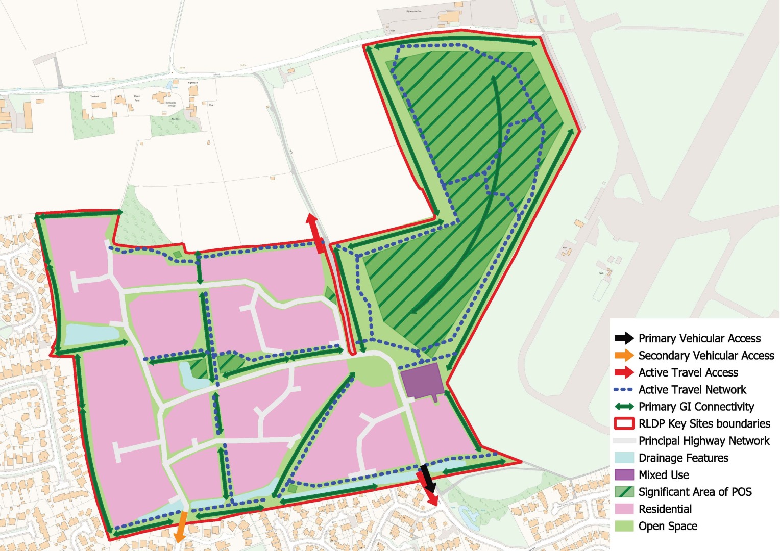
Land at Church Farm, St Athan
6.95 Two key site allocations are identified in St Athan, which would deliver eastern and western extensions to the settlement. St Athan is a primary settlement served by an English medium primary school and other facilities including small scale retail, a post office and other community facilities. In addition, the adjoining Bro Tathan Enterprise Zone provides a range of employment opportunities, with the delivery of a significant number of additional jobs expected over the plan period, ensuring new housing is co-located with employment opportunities. St Athan is served by a bus service linking the settlement to Llantwit Major and Cardiff, via Barry with land also being safeguarded for a station and bus/rail interchange under policies HG1 KS5 and TR1.
6.96 The allocation at Church Farm, which represents the eastern extension to St Athan, comprises two areas, which are anticipated to be developed in a phased manner. The western area, which was a housing allocation in the adopted LDP 2011-2026 comprises two agricultural fields and extends to approximately 8.4 hectares in total. The site is bound to the north by St Athan Primary School, a residential property and farm buildings. The B4265 adjoins the site to the south, beyond which are residential properties, the Vale of Glamorgan railway line, and agricultural land. The Grade II Listed St Athan War Memorial is located to the south-west of the site, adjacent to the junction of Gileston Road and the B4265. Gileston Road bounds the site to the west, beyond which are residential properties and a Co-op food store.
6.97 The eastern parcel (16ha) comprises 4 field parcels separated by hedgerows with a farm track and further agricultural land beyond. A petrol station is located just beyond the South Eastern boundary of the site, as well as the access road to the Aberthaw Power Station site. The B4265 is also the southern boundary to this parcel of land.
6.98 The majority of the site is low grade agricultural land (Grade 3b), although South Eastern corner (approximately 10% of the overall site) is identified as Best and Most Versatile Agricultural Land (Grade 2/3a).
6.99 Access to the western parcel (Phase 1) will be from Gileston Road. A second access point directly on to the B4265 will be delivered as part of the development of the eastern parcel (Phase 2), with an internal road network connecting these two areas together. Phase 1 will deliver 232 units and 1,672 – 1,858 sq m (18,000-20,000 sq ft) Class A1 retail food store. Phase 2 is housing, delivering 300 homes.
6.100 The delivery of a food store as part of the first phase will increase the services available in St Athan, reducing the need for residents to travel to other settlements for convenience shopping. In line with the sequential approach to the location of retail facilities, the food store must be located in the North Western corner of the site as this part of the site is in closest proximity to the defined retail centre of St Athan.
6.101 Dwr Cymru Welsh Water have advised that Hydraulic Modelling Assessments (HMA) will be required to establish the impact of the proposal on both the existing water network and public sewerage network and potential developers would be expected to fund investigations during pre-planning stages.
6.102 There is limited capacity in West Aberthaw Waste Water Treatment Works (WwTW). A scheme to upgrade the WwTW is planned as part of the current AMP investment period (2025-2030). If the development wishes to connect in advance of the completion of the AMP scheme, then the developer would need to undertake a Developer Impact Assessment (DIA) to establish the reinforcement works needed at the WwTW to accommodate their site.
HG1 KS4 - LAND AT CHURCH FARM, ST ATHAN
Land at Church Farm, as shown on the Proposals Map, is allocated as a key housing-led site. The 24.1 Ha site will deliver 532 homes over the plan period and a class A1 retail foodstore of up to 20,000 sq ft (1,858 sq m) with associated car parking.
The development of the site must adhere to the Placemaking Principles set out in Policy SP4 Placemaking and the criteria in Policy PGD1 Creating Well Designed Places. In addition, the site must comply with the following requirements:
Affordable Housing
- The provision of a minimum of 81 affordable housing units on phase 1 and 105 affordable units on phase 2 (35%) with a unit mix reflecting the requirements of the latest Local Housing Market Assessment and the Council’s waiting list data. In order to deliver a greater social mix, the affordable units should be dispersed across the site in clusters of no more than 10 units, with their delivery being phased across the development trajectory.
Sustainable Transport and Highways
- A contribution towards off-site improvements to the capacity and flow of junctions on the strategic highway network as informed by the Strategic Transport Assessment and site-specific Transport Assessment.
- The provision of an access point off Gileston Road to serve Phase 1 of the development and the foodstore. Gileston Road will require widening utilising land within the site boundary and the provision of an Active Travel route along the boundary of the site fronting Gileston Road and the B4265.
- The junction of Gileston Road and the B4265 must be upgraded to a signalised junction with controlled pedestrian/cycle crossing facilities.
- Phase 2 will require the provision of a suitably designed priority junction on to the B4265, which must connect via a spine link road through to Phase 1 of the development.
- A new access to St Athan Primary through the site to replace the existing sub-standard access to the school from Rock Road.
- The bus stop at the Gileston Road/B4265 junction must be upgraded.
Heritage
- The development and associated off site highway improvements must respect the setting of the Grade II war memorial located to the south of the site.
Community Infrastructure
- The transfer of land to the east of St Athan Primary to the Vale of Glamorgan Council as part of Phase 2 to allow for the redevelopment and expansion of St Athan Primary.
- In addition, an off-site contribution towards the delivery of additional school places in accordance with capacity requirements within the catchment area.
- A contribution towards the provision and enhancement of community facilities in the area.
- A contribution towards training and development for the commercial element of the development on Phase 1.
Green Infrastructure, Recreation Spaces and Biodiversity
- In accordance with the requirements of Policy CI1, the site must include a number of well-designed areas of useable open space, including informal and equipped play spaces, with appropriate green infrastructure connections between them. A playing pitch will be required as part of the outdoor sports provision requirement on Phase 2 of the development. It is expected that the open space will be delivered proportionately across the two phases of development. Where the requirements cannot be met fully on site, an off-site contribution will be required.
- Hedgerows and other green infrastructure assets on the site boundary and within the site should be retained and included as part of green infrastructure corridors through the site wherever possible. Where this cannot be achieved, for example at the entrance to the site, appropriate compensatory planting will be required.
Flood Risk and Sustainable Drainage
- The site must incorporate appropriate high quality sustainable drainage systems (SuDS) which integrate the surface water drainage function with open space and provide opportunities to deliver biodiversity.

Land to the west of St Athan
6.103 Land west of St Athan is a key site comprising two parcels of land on the edge of the primary settlement of St Athan. The larger of the two parcels is 28.1 Ha and the smaller area, on the opposite side of the B4265, is 1.5 Ha.
6.104 The larger area comprises low quality (Grade 3b) agricultural land divided into a number of large irregular shaped field parcels, which are used for grazing, separated by hedgerows. A small number of derelict structures and buildings are located throughout the site.
6.105 The northern boundary of this site is formed by Llantwit Road, with an isolated dwelling in the North West corner of the site and a row of detached residential properties to the North East. A series of utilitarian industrial buildings associated with the Bro Tathan Enterprise Zone are located further to the north. To the east of the site is the settlement of St Athan with land immediately to the east, including Paul Lewis St Athan Community Centre with associated sports pitches, and both equipped and non-equipped public open space. Housing is located on the eastern side of the community centre. The site’s southern boundary is formed by the Vale of Glamorgan Railway Line which runs westwards to Bridgend and eastwards to Cardiff with an approximately 120m section of the site’s southeastern boundary formed by the B4265. Vegetation, of varying width and density runs along both of these boundaries. An unnamed road which connects Llantwit Road to the B4265 and runs over the railway line forms the site’s western boundary.
6.106 The smaller parcel consists of a single field which is used for the grazing of animals. It is also low-grade agricultural land (Grade 3b). It is bound to the north and west by the B4265. The southern boundary is the railway line, and to the east, separated by a hedgerow are two further agricultural fields.
6.107 The larger parcel is identified for residential led development, and the smaller parcel is allocated for a mix of uses which includes the safeguarding of land for the provision of a new station and rail/bus interchange with associated car parking. The mix of uses may also include small scale commercial development, with the potential for above ground floor residential development.
6.108 Dwr Cymru Welsh Water have advised that Hydraulic Modelling Assessments (HMA) will be required to establish the impact of the proposal on both the existing water network and public sewerage network, and potential developers would be expected to fund investigations during pre-planning stages.
6.109 There is limited capacity in West Aberthaw Waste Water Treatment Works (WwTW). A scheme to upgrade the WwTW is planned as part of the current AMP investment period (2025-2030). If the development wishes to connect in advance of the completion of the AMP scheme, then the developer would need to undertake a Developer Impact Assessment (DIA) to establish the reinforcement works needed at the WwTW to accommodate their site.
HG1 KS5 - LAND TO THE WEST OF ST ATHAN
Land west of St Athan, as shown on the Proposals Map, is allocated as a key mixed use site. The 29.6 Ha site comprises two parcels of land that collectively will deliver 600 homes over the plan period, alongside new community and commercial facilities and land safeguarded for the provision of a new station and bus/train interchange at St Athan.
The development of the site must adhere to the Placemaking Principles set out in Policy SP4 Placemaking and the criteria in Policy PGD1 Creating Well Designed Places. In addition, the site must comply with the following requirements:
Affordable Housing
- The provision of a minimum of 210 affordable housing units (35%) with a unit mix reflecting the requirements of the latest Local Housing Market Assessment and the Council’s waiting list data. In order to deliver a greater social mix, the affordable units should be dispersed across the site in clusters of no more than 10 units, with their delivery being phased across the development trajectory.
Sustainable Transport and Highways
- The provision of an Active Travel route along the B4265 between the site entrance and the Gileston Road junction to the east.
- A contribution towards the delivery of an Active Travel route between St Athan and Llantwit Major.
- The delivery of a signalised junction on to the B4265 with Active Travel crossing points providing access into both parcels within the site allocation.
- Safeguarding of land within the smaller parcel to allow for the delivery of a new rail station at St Athan including appropriate car parking to support the use of the site as a bus/rail interchange.
- A contribution towards off-site improvements to the capacity and flow of junctions on the strategic highway network as informed by the Strategic Transport Assessment and site-specific Transport Assessment.
- Safeguarding of land within the site boundary of the larger site to allow for the provision of a pedestrian and cycle bridge to serve a new education facility on land to the south as identified in Policy CI3 (2) Land south of the railway, St Athan.
- The road layout and width should be of a sufficient width and design to allow for the provision of a loop road to facilitate a bus connection.
- The provision of pedestrian/cycle links to Llantwit Road and pedestrian footway improvements along Llantwit Road.
Community Infrastructure
- An off-site contribution towards the delivery of additional school places in accordance with capacity requirements within the catchment area.
- The provision of an on-site community building to serve the development.
Green Infrastructure, Recreation Spaces and Biodiversity
- The extension of St Athan Recreation Ground including the provision of an additional sports pitch, areas of equipped play and community allotments.
- In addition, the site must include a number of other well-designed areas of useable open space, including informal and equipped play spaces, with appropriate green infrastructure connections between them.
- Hedgerows and other green infrastructure assets on the site boundary and within the site should be retained and included as part of green infrastructure corridors through the site wherever possible. Where this cannot be achieved, appropriate compensatory planting will be required.
Flood Risk and Sustainable Drainage
- The site must incorporate appropriate high quality sustainable drainage systems (SuDS) which integrate the surface water drainage function with open space and provide opportunities to deliver biodiversity.
- Built development should avoid the small area of Zone 3 surface water and small watercourses flooding on the eastern periphery of the site.
Heritage
- The development should consider and respond positively to the setting of the listed buildings on Llantwit Road, which are in close proximity to the site boundary.

6.110 The former Eagleswell Primary School site, located on Eagleswell Road in Llantwit Major, has been redeveloped to provide 90 units of temporary accommodation. This comprises a mix of single and two-storey homes intended as short-term housing for individuals and households in need. The development is subject to a temporary planning permission for a five-year period from 2024, after which the units will be relocated to other sites within the Vale. As the units provide housing in the short to medium term and will continue to do so in the longer term, they have been included within the housing completions for this plan.
6.111 Once the temporary units are relocated by 2029, the site will become available for redevelopment to provide permanent accommodation. As the units have already been counted as completions on this site, any future dwellings delivered through redevelopment will not be included in the housing supply figures. The site is in Council ownership and is expected to be brought forward for an affordable housing-led development. Subject to identified need at the time of redevelopment, there may also be potential for part of the site to accommodate appropriate community uses.
AFFORDABLE HOUSING
SP7 – AFFORDABLE HOUSING PROVISION
The residential requirement identified in Policy SP6 is expected to contribute to the established community housing needs of the Vale of Glamorgan by delivering a minimum of 3,070 affordable residential units over the plan period.
In meeting this target, a mix of affordable housing will be required, informed by the Local Housing Market Assessment LHMA, waiting list data and the Older Persons Housing Strategy. This should include a range of tenures, types and sizes of homes, as well as an appropriate balance of general needs and specialist accommodation.
6.112 The delivery of affordable housing is a key objective of the RLDP Strategy. The relative strength of the Vale of Glamorgan’s housing market in recent years has resulted in many local people experiencing difficulties in purchasing suitable housing on the open market.
6.113 The latest Local Housing Market Assessment (LHMA 2023) was approved by Cabinet in May 2024 and submitted to the Welsh Government, who confirmed in June 2025 that they are content for the LHMA to be used as an evidence base for key policies and plans, including the RLDP.
6.114 The headline figure of need in the LHMA - based on the 2018-based Welsh Government principal household projections - is 1,075 units per annum for the first five years of the LHMA period, followed by a further 154 units per annum. If calculated over a 15-year period, this equates to an average annual need of 461 units.
6.115 The LHMA also includes variant projections. If the RLDP household projections are used instead of the 2018-based Welsh Government projections, the identified need increases to 1,114 units per annum for the first five years, and 196 units per annum thereafter, equating to an average of 502 units per annum over 15 years.
6.116 In both scenarios, the tenure split is broadly 65% social rented and 35% intermediate or low-cost home ownership units. The housing need identified using each method is set out below:
|
Table 4: LHMA 2023 Affordable Housing Need Figures |
||
|
Headline Figures (2018 based projections) |
RLDP Projection Figures |
|
|
Need in first 5 years (per annum) |
1,075 |
1,114 |
|
Social rent (first 5 years per annum) |
687 |
715 |
|
Intermediate and low-cost home ownership (first 5 years per annum) |
388 |
399 |
|
Need for next 10 years (per annum) |
154 |
196 |
|
Need if considered over 15 years (per annum) |
461 |
502 |
6.117 The LHMA highlights that the existing backlog of need from people on the housing waiting list is most acute within Barry and Penarth/Llandough, although there are significant people on the waiting list across all areas of the Vale.
6.118 The LHMA indicates that most of the need for affordable housing throughout the Vale is for smaller one and two-bedroom units for social rent, with a shortfall each year of 439 and 170, respectively. The demand for smaller homes reflects recent societal trends in household composition and the high prevalence of single-person households and households comprised of couples with no children.
6.119 To help address the need identified, Policy SP7 anticipates that RLDP will contribute towards delivering a minimum of 3,070 affordable dwellings over the plan period. The target is indicative and relates only to those affordable homes secured through the planning system and will be secured in accordance with the requirements set out under Policy SP8. The figure includes contributions from committed sites, additional affordable housing secured through Section 106 agreements from new allocations, including small scale affordable housing led sites, and from windfall and small sites.
6.120 In calculating the affordable housing target, the Council recognises that the number of affordable homes delivered during the plan period could be lower as a result of site viability constraints or greater where they are on sites delivered by the Council, Registered Social Landlords or on land owned by the Welsh Government.
|
Source |
Affordable Dwellings |
|
Number of affordable dwellings delivered April 1st, 2021, to the 31st of March 2025 |
702 |
|
Sites with permission and or under construction on April 1st 2025 |
908 |
|
Contribution from existing LDP allocations to be carried forward |
222 |
|
Contributions from Key Housing Sites and additional housing sites |
952 |
|
Contributions from Affordable Housing Led Sites |
62 |
|
Contributions from Large Windfall Developments |
224 |
|
Total Affordable Units |
3,070 |
6.121 The Council will seek to secure an appropriate level and mix of affordable housing in all proposed residential developments and may include social and intermediate rent and low-cost home ownership, as well as co-operative housing, and those requiring specialist housing, including for older people.
AFFORDABLE HOUSING REQUIREMENTS
6.122 As part of the preparation of the Deposit RLDP, the Council has undertaken a review of the current adopted Vale of Glamorgan LDP affordable housing policies. Utilising updated land values, build costs (including costs associated with delivering net zero dwellings) and latest house price data, and tested a range of house sizes and development typologies across 5 agreed housing market areas present within the Vale of Glamorgan.
6.123 The review concluded that the Councils’ existing affordable housing policies remained financially viable, with new developments have the capability to support on site affordable housing contributions of 30% in the Barry housing market area, 35% in Llantwit Major, Rhoose and St Athan on residential and mixed-use sites resulting in a net gain of 5 dwellings. Within Penarth, Dinas Powys and Sully and within the Primary and Minor Rural Settlements, new development will be required to provide 40% affordable housing generating a net gain of 1 or more dwellings; and developments involving either the subdivision of existing dwellings or the conversion of existing buildings, where these result in a net gain of 2 or more dwellings. Proposals involving the conversion of existing rural buildings are exempt from the affordable housing requirements.
6.124 Accordingly, Strategic Policy 8 sets out the Council’s requirements for the provision of affordable housing in line with the findings of the Vale wide viability appraisal. These requirements shall apply to all proposals within the delineated settlement boundaries of the relevant settlement cited, as shown on the Proposals Map. Further details on the settlements identified as being Primary and Minor Rural Settlements within the policy is set out into SP2 Settlement Hierarchy.
6.125 Outside of the delineated settlement boundaries proposals for additional housing will be strictly controlled and limited to the provision of affordable housing exceptions sites or housing in support of rural enterprises.
POLICY SP8 - AFFORDABLE HOUSING REQUIREMENTS
Residential developments (including mixed use schemes) will be required to contribute to addressing affordable housing need and should meet the levels of affordable housing set out below:
|
Settlements |
Affordable Housing Requirement % |
Policy Threshold |
|
Barry |
30% |
5 dwellings net gain |
|
Rhoose, St Athan, Llantwit Major |
35% |
5 dwellings net gain |
|
Penarth, Dinas Powys, Llandough, Sully, Cowbridge |
40% |
1 dwelling net gain new build. 2 dwelling net gain for conversions of existing buildings |
|
Primary and Minor Rural Settlements outside the strategic growth area |
40% |
1 dwelling net gain new build. 2 dwelling net gain for conversions of existing buildings |
|
Affordable housing led allocations |
50% |
As per allocation |
The provision of affordable housing will be negotiated on a site-by-site basis considering the evidenced viability of the development.
On sites of 5 dwellings and above, the Council shall require the provision of affordable housing to be provided on site, unless exceptional circumstances are demonstrated, with the requirement being rounded up to the nearest whole number, with the residual amount being provided as an equivalent financial contribution.
In circumstance where an off-site financial contribution is made, the monies received will be used to deliver alternative affordable housing in the Vale of Glamorgan.
Where developers claim that the target is unviable, a detailed viability assessment must be submitted and independently reviewed.
The exact mix of affordable housing required will be considered on a case-by-case basis having regard to the Council’s latest needs evidence at the time of the application.
6.126 Having regard to the findings of the Council’s latest LHMA and viability evidence the Council will seek a tenure split of affordable housing to be delivered on site of 65% social rented housing and 35% intermediate housing, which may be either intermediate rented housing or low-cost home ownership (LCHO) housing provided it satisfies the TAN 2 definition of Affordable Housing. However, tenure mix can be considered on a case-by-case basis where evidence suggests that the Council’s preferred mix is not appropriate, or deliverable or local evidence of need indicates an alternative mix would be more appropriate.
6.127 The Council’s preference is always for on-site provision of affordable housing but recognises on smaller sites the requirement will often equate to less than whole dwellings. In such circumstances, given the small scale of development, it is appropriate to require a financial contribution proportionate to the residual requirement, which can be pooled and used to enable affordable housing off-site. The Council’s approach to financial contributions (commuted sums) is set out in more detail in the adopted Affordable Housing Supplementary Planning Guidance (SPG). Commuted sums will be calculated using the equivalent cost of on-site provision and will be used to assist development of affordable housing to meet identified needs.
6.128 Where it is demonstrated that there are proven economic circumstances that impact upon the delivery of the affordable housing, for example where market circumstances have changed or where existing use values prevent the policy target being achieved, the Council may negotiate the level, type, tenure and nature of on-site provision or where appropriate, off-site provision. In instances where a financial contribution in lieu of affordable housing provision is acceptable, the most appropriate use of this funding will be determined by the Council. This could include the provision of affordable housing on land in ownership of the Council or an RSL or improvements to existing affordable housing or may allow the Council to use funding to provide affordable housing in areas of greatest need.
6.129 Appropriate planning conditions and/or planning obligations will be utilised to ensure that affordable housing provided through new development will remain affordable in perpetuity. Further detailed guidance on the implementation of this policy is set out in the Council’s Affordable Housing SPG.
RURAL AFFORDABLE HOUSING LED SITES
6.130 In accordance with national planning policy, the RLDP strategy and policies seek to maximise opportunities for the delivery of affordable housing. This includes identifying appropriate affordable housing led sites that will deliver as a minimum 50% affordable housing. Accordingly, Policy HG4 identifies several sites located within Primary Settlements outside of the Strategic Growth Area and Minor Rural Settlements which have been subject to site specific viability appraisals where it has been shown that the development economics of the site can support 50% affordable housing.
HG4 - RURAL AFFORDABLE HOUSING LED SITES
The following sites are allocated as affordable housing led sites where there will be a requirement for the provision of a minimum 50% affordable housing to meet the affordable housing needs of the local community. In addition, the Council will require developers to provide a mix of market housing that will contribute to specific housing market needs of the community.
|
Site Reference |
Settlement |
Site Name |
Number of units |
|
Colwinston |
Land to the East of Colwinston |
25 |
|
|
Aberthin |
Land west of Maendy Road |
25 |
|
|
Wick |
Land at Heol Fain |
50 |
|
|
Fferm Goch |
Land north of West Winds Business Park |
22 |
|
|
Dwelling Contribution |
122 |
Applicants will need to demonstrate how both the market and affordable housing provides for the local housing needs of community in terms of tenure, type and size of dwellings so that a range of housing is delivered to meet the needs of different groups in the local community.
6.131 Planning Policy Wales highlights that planning authorities should identify sites where interventions may be required to deliver the housing supply. It also emphasises that there must be a sufficient number of sites suitable for the “full range of housing types to address the identified needs of communities…(and) should promote sustainable residential mixed tenure communities with ‘barrier free’ housing, for example built to Lifetime Homes standards to enable people to live independently and safely in their own homes for longer [10]”.
6.132 Accordingly, to ensure that new developments respond to the high demand for smaller properties, as identified in the LHMA, priority will be given to affordable homes that are small to medium-sized, typically comprising one to three bedrooms. Representations received from the local community through the RLDP process also highlighted a desire for new housing developments to offer opportunities for accessing smaller market homes. This is particularly relevant in the rural Vale, where housing choices are more limited. Providing smaller, more affordable market homes may assist first-time buyers and enable older residents to downsize to more manageable properties within their local area. Affordable housing-led sites will therefore need to demonstrate that an appropriate range of both affordable and market dwellings has been provided.
6.133 Affordable housing-led sites will be required to deliver a minimum of 50% affordable housing, secured through a Section 106 agreement. Proposals delivering less than 50% affordable housing will not be acceptable, as the allocation of these sites is specifically intended to meet identified needs in rural wards that would otherwise be difficult to address. However, proposals delivering more than 50% affordable housing, including where the site is brought forward by a social housing provide, will be supported. In all cases, affordable housing units on rural affordable housing-led sites will be subject to a local lettings policy to ensure that they are available to residents with a local connection at both initial and subsequent occupations.
AFFORDABLE HOUSING EXCEPTIONS
6.124 The LHMA highlights that affordable housing need exists across the whole authority, including in rural areas, where there is more limited opportunity to deliver affordable housing within defined settlement boundaries. To assist in meeting this specific rural housing need, the Council will support proposals for affordable local housing in rural areas on land that would not ordinarily be acceptable for housing development where the provisions contained in Policy HG5 are satisfied.
HG5 - AFFORDABLE HOUSING EXCEPTION SITES
Proposals for 100% small scale affordable housing developments will be permitted outside settlement boundaries where:
- The proposal has a distinct physical or visual relationship with a defined settlement outside of the Strategic Growth Area as set out in Policy SP2 on Settlement Hierarchy.
- The proposal meets an identified local need which cannot be satisfied within identified settlement boundaries;
- The proposal site would represent a logical extension of the settlement and would not require arbitrary subdivision of a larger site;
- The development is of a scale that is compatible with the layout, density, fabric and appearance of the existing settlement;
- The proposed dwelling(s) will be of a size, tenure and design which is commensurate with the identified affordable housing need, taking account of the affordable housing already planned in the housing market area;
- There is no loss of land with significant recreational, amenity, agricultural or natural heritage value; and
- Secure mechanisms are in place to ensure the property shall remain affordable in perpetuity and made available in accordance with the Council’s local lettings policy.
6.135 In seeking to deliver sustainable communities, the RLDP Strategy directs new housing to settlements within the Strategic Growth Area. However, it is recognised that there is a need for affordable housing across the whole authority, including within wards in more rural areas located outside the Strategic Growth Area. This policy allows for small-scale affordable housing development in these areas as ‘exceptions’ to the general housing policies of the RLDP.
6.136 Policy HG5 applies only to proposals relating to settlements located outside the Strategic Growth Area and specifically identified in the Settlement Hierarchy under Policy SP2. This includes Minor Rural Settlements and the Primary Settlements of Wenvoe, Culverhouse Cross, and Wick. Exception sites will not be supported in smaller rural settlements or hamlets without a defined settlement boundary, as these locations generally lack the services and facilities necessary to support new development. Exception sites will also not be supported within the Key Settlements, Service Centres, and Primary Settlements located within the Strategic Growth Area, as these larger settlements typically offer more opportunities to deliver affordable housing through allocated sites and windfall developments within defined settlement boundaries.
6.137 Policy HG4 makes provision for affordable housing-led sites in locations outside the Strategic Growth Area. These sites, which are allocated for a minimum of 50% affordable housing, are included within the settlement boundary. Exception sites, however, are located outside the settlement boundary and are expected to deliver 100% affordable housing. Development outside the settlement boundary is only justified in these circumstances based on affordable housing need. Proposals that include market housing as a means of enabling local housing need will therefore not normally be supported, as it is expected that all local needs housing schemes will be delivered without the need for cross-market subsidy.
6.138 This policy applies to the provision of both general needs and specialist affordable housing, such as housing for older people, extra care schemes, or supported living, where it can be demonstrated that the development will remain affordable in perpetuity.
6.139 For the purposes of this policy, ‘small-scale’ will generally mean no more than 10 dwellings on sites adjoining Minor Rural Settlements. In Primary Settlements outside the Strategic Growth Area, proposals for more than 10 dwellings may be acceptable where required to meet a specific need and where the number of dwellings is proportionate to the size of the settlement. In assessing the scale and extent of any proposed local needs housing, consideration should also be given to affordable housing already planned in the ward or nearby area, including sites with existing planning permissions and those allocated in the RLDP. The size and type of affordable housing proposed should reflect the identified local need in the area.
6.140 In considering site suitability, Policy HG5 requires that site boundaries follow existing boundary lines; arbitrary sub-divisions of sites will not be acceptable. Similarly, large sites that are intentionally low in density to meet the definition of small-scale housing will not be supported. Development densities must align with the minimum requirements set out in Policy PGD2: Residential Development Densities.
6.141 In general, the Council will require affordable housing to be delivered by a Registered Social Landlord (RSL), the Council, or the community itself—for example, via a community land trust. For developments proposed by a private developer, the Council will require the dwelling(s) to remain affordable in perpetuity. This will be secured through a planning condition or legal agreement, which will cap the resale value of the property at an affordable level. This ensures that the dwelling is of a design and scale that remains affordable to the wider community.
6.142 A local lettings policy will be required as part of a legal agreement to ensure that both initial and subsequent occupiers have a local connection to the area, helping to maintain sustainable, integrated communities.
SPECIALIST HOUSING
HG6 – PROVISION OF SPECIALIST ACCOMMODATION
The Council will support the development of specialist accommodation to meet the diverse housing needs of the Vale of Glamorgan’s population. Proposals for specialist housing will be supported where:
- The development responds to an identified local need, as evidenced by the latest Local Housing Market Assessment (LHMA), the Older Persons Housing Strategy, or other relevant needs assessments;
- The accommodation is appropriately designed to meet the specific needs of the intended residents, including older people, people with disabilities, those with mental health needs, and other vulnerable groups;
- The development is located in an accessible and sustainable location, with good access to public transport, community facilities, health services, and local amenities;
- The development ensures integration with the wider community and promotes inclusive, mixed communities; and
- It includes appropriate levels of care and support, where required, either on-site or through established local services;
6.143 The provision of specialist accommodation is essential to ensuring that the housing needs of all residents in the Vale of Glamorgan are met, particularly those who require tailored support due to age, disability, or other vulnerabilities. The population of the Vale is ageing, and the number of residents with complex health and social care needs is increasing.
6.144 Specialist accommodation includes, but is not limited to, extra care housing, supported living schemes, wheelchair-accessible homes, and housing with integrated care services. These forms of housing enable individuals to live independently for longer, reduce pressure on health and social care services, and contribute to the creation of inclusive and resilient communities. The provision of specialist housing for those in need of it will also help to free up general needs housing to other households.
6.145 Locating specialist accommodation in accessible areas with good transport links and proximity to essential services is critical to ensuring residents can maintain independence and participate in community life. The Council’s Older Persons Housing Strategy, Creating Homes and Neighbourhoods for Later Life 2022-36, sets out a vision in the Vale of Glamorgan Council which is “to secure the best quality of life for older people to live as independently as possible in later life. This means delivering a range of accommodation that enables older people to live fulfilling lives and enjoy good health in attractive homes that meet their needs and allow them to retain their independence as they age”. This is reinforced in the Age Friendly Vale Strategy and Action Plan.
6.146 The Council will work in partnership with RSLs, care providers, and other stakeholders to bring forward appropriate schemes. However, this policy would also apply to the provision of any private specialist accommodation schemes. Proposals will be expected to demonstrate how they respond to identified local needs and comply with relevant design and accessibility standards.
HOUSES IN MULTIPLE OCCUPATION
6.147 Houses in multiple occupation (HMOs) are properties which are occupied by unrelated households that share one or more facilities such as a bathroom or kitchen. HMOs can provide useful accommodation, but in many cases the property and area they are in was not originally designed for such intensive residential use.
6.148 In recent years there has been a growing increase in the number of HMOs in the urban parts of the Vale, particularly in Barry, and it is anticipated numbers will increase further due to the housing crisis and an increased demand for single person accommodation. Over concentration of HMOs in an area can alter its character, population mix and increase demands for facilities and services and impact on residential amenity.
6.149 Accordingly, Policy HG6 seeks manage proposals for the conversion of buildings or the change of use of existing residential properties in a manner that is sustainable and does not lead to harmful concentrations of HMOs, ensuring that residential amenity and the environment is not adversely affected.
HG7 - HOUSES IN MULTIPLE OCCUPATION (HMOs)
Proposals for the change of use from Use Class C3 (dwellinghouse) to C4 (Houses in Multiple Occupation (HMO)) or Sui Generis (a large HMO with more than six people), or the intensification of the use from C4 to Sui Generis, or the development of a new build HMO will only be permitted where:
- HMO properties would not represent 10% or more of residential properties within a 50-metre radius of the application property, or the application property tips the concentration to 10% or more;
- It would not result in any residential property (C3 use) being ‘sandwiched’ between two HMOs;
- On small streets, proposals will not be supported where it would create a disproportionate over concentration of HMOs;
- The scale and intensity of use would be compatible with the existing building and adjoining and nearby uses.
HMO proposals that exceed the thresholds above will only be permitted where there are exceptional circumstances or other material considerations that demonstrably outweigh any concerns over HMO concentrations.
6.150 Policy HG7 applies to both the change of use of an existing dwelling to either a small HMO of up to six people, which is within Use Class C4 or a large HMO with more than six people (sui generis). It also applies to existing HMOs where the use intensifies (for example by extending a six person or less HMO to accommodate more than six people, as this would be a change of use from C4 to sui generis). The policy is also relevant to new build HMOs, irrespective of their size.
6.151 The policy defines thresholds above which further concentrations of HMOs would be deemed to be a harmful concentration. This includes the ‘sandwich test’, which seeks to prevent the development of new HMOs if it would result in a residential property being sandwiched between two adjoining HMOs sharing the same road frontage, and a ‘radius test’ setting the maximum level of HMOs within a 50-metre radius as 10% of all households. The 50-metre radius is calculated from the central point of the application site and would include any residential property in use class C3, C4 or sui generis (large HMO) whose curtilage is within a 50-metre radius.
6.152 There are some areas comprising small streets where the concentration of HMOs would potentially have a greater harmful impact. On streets of 10 or less dwellings across both sides of the street, it is considered that 2 HMOs is an appropriate limit above which there would be harm caused. On small streets of between 11 and 34 dwellings, HMOs should be limited to no more than 20% of residential properties on the street (across both sides of the street). Proposals on streets exceeding 35 or more properties would only be required to meet criterion 1 and 2.
6.153 The building proposed for conversion must be suitable for use as an HMO without requiring significant extensions or alterations that would change its character or appearance. The conversion must be compatible with both the building and the surrounding area in terms of intensity and scale, as over-crowded buildings can lead to lower living standards. To prevent cramped living conditions, HMO proposals are expected to follow the Space Standards set out in the Shared Regulatory Services’ HMO Licensing Fire Safety and Amenity Standards (2014) , regardless of whether the property requires a license under the Housing Act.[11] HMOs must also provide appropriate private amenity space, in accordance with the standards set out in the Council’s adopted Residential and Householder Development Supplementary Planning Guidance.
6.154 There may be some exceptional circumstances where a proposed HMO exceeds one or more of the identified thresholds but where other considerations outweigh the potential over-concentration, or a more flexible approach may be required. This may include circumstances where a property is a long-term empty property, and it is unlikely that a C3 use would be brought forward by virtue of the nature of the building or viability. In these circumstances a statement setting out a robust justification for the HMO proposal will be required. This should include marketing evidence demonstrating that the property has been advertised for sale as a residential dwelling at a reasonable asking price for a minimum of 12 months.
CONVERSION AND RENOVATION OF RURAL BUILDINGS
HG8 - CONVERSION AND RENOVATION OF RURAL BUILDINGS
Proposals for the conversion or renovation of existing rural buildings for rural enterprise, tourism, community or residential use will be acceptable where:
- Conversion of an existing rural building would not give rise to the need for a replacement building; and
- Reuse can be achieved without substantial reconstruction, extension or alteration that unacceptably affects the appearance and rural character of the building or its setting
- Proposals for the residential conversion or renovation of existing rural buildings will only be permitted where:
- The building has been appropriately marketed for other alternative uses such as farm diversification, business, community, tourism, or recreational uses and it has been demonstrated that such alternative uses are not viable;
- The building is accessible by regular public transport, and safe Active Travel routes; and
- The location of the building is sustainable in terms of access to local services and community facilities.
To ensure that that the character and appearance of the building is preserved in the long term, the Council may seek to withdraw permitted development rights to restrict future extensions or alterations to the property.
6.155 With changes in farming practice, many rural buildings are no longer required for their original purpose. In the rural Vale, some of these buildings add to the character of the countryside and to local distinctiveness. Where possible the Council wishes to see rural buildings, particularly those of architectural or historic interest, retained. The Council’s preference is for these buildings to be developed for alternative uses that contribute positively to Vale of Glamorgan’s rural economy in line with national policy.
6.156 To ensure that conversions make a positive contribution to the rural economy, Criterion 3 requires proposals for residential use to be supported by appropriate marketing evidence to demonstrate that the building has been marketed for other alternative uses for at least 12 months by a local property agent. Information from the agent or applicant regarding demand for alternative uses could take the form of a marketing report or correspondence from the relevant property agent. The type of information must include the following:
- The length of time the rural building has not been used for agricultural purposes;
- The types of uses which the rural building has been marketed for, what the marketing strategy involved and its duration; and
- The amount of interest in the rural building during the marketing period – this should detail the number of queries, the type of uses sought, and if known, the reason for not pursuing any initial enquiries.
6.157 Notwithstanding these preferences, the most common proposals in the Vale of Glamorgan are for the conversion of traditional rural buildings to residential use. Such proposals can lead to a dispersed pattern of dwellings which generates new and longer trips to settlements and services and place additional pressure on the Council to provide essential services and facilities often in isolated locations. Criterion 4 therefore states that residential use will only be acceptable in locations which are conveniently served by regular public transport and have safe and accessible pedestrian and cycle routes linking them to local services and facilities. This will ensure that development would not result in occupiers being overly reliant on the private motor vehicle.
6.158 In more isolated rural locations where residential development would otherwise not be acceptable, proposals for residential conversions will be limited to tourist accommodation and occupancy conditions will be imposed to prevent long term residential occupation.
6.159 Not all rural buildings are necessarily suitable for conversion, and the following points should be considered when determining whether to convert a building in the countryside to residential use. This list is not exhaustive.
- Only buildings of sufficient size to accommodate the proposed alternative use will be considered acceptable. For residential conversions, buildings must have a minimum footprint of 40m² and should not require extensions to meet the necessary size requirements.
- Conversions of makeshift or temporary structures will not be permitted.
- Residential conversion of buildings that were granted planning permission as replacement structures for another use will not be permitted, as such permission would have been based on the building continuing the same use as the one it replaced.
6.160 The conversion of rural buildings must be sympathetic to their location and not require any extensions or alterations which would materially alter the character of the building including its setting in the rural landscape. Any major remodelling of either the building itself or its setting in a manner which would not maintain or enhance its existing rural character is unlikely to be considered favourably. Where permission is granted, the Council will withdraw permitted development rights to restrict future extensions or alterations to the property to ensure that that the character and appearance of the building is preserved in the long term.
6.161 The Council has produced Supplementary Planning Guidance on the Conversion of Rural Buildings, setting out the considerations when proposing alternative uses to rural buildings.
REPLACEMENT DWELLINGS, RESIDENTIAL EXTENSIONS AND ANNEXES IN THE COUNTRYSIDE
6.162 Replacement dwellings, residential extensions and the provision of annexed accommodation account for a substantial proportion of all new development in the Vale. In a countryside location it is important that such proposals are well-designed since excessively large and poorly designed proposals can individually, and cumulatively, damage both the character of the property and the local landscape. Policy HG9 sets out the criteria against which determining such proposals within a countryside setting will be assessed.
HG9 - REPLACEMENT DWELLINGS, RESIDENTIAL EXTENSIONS AND ANNEXES IN THE COUNTRYSIDE
Proposals for the replacement of an existing dwelling in the countryside will be permitted where:
- The proposal would comply with the requirements of Policy CC2 - Presumption Against Demolition;
- The dwelling has an established lawful residential use;
- It would not result in the loss of a dwelling which contributes significantly to the rural character of the area, unless it can first be demonstrated that the building is structurally unsound, and repairs are economically unviable;
- The proposal would, by reason of its scale, siting, design, materials, landscaping and external appearance, be compatible with the surrounding built and natural environment and have no materially greater impact on the landscape; and
- The proposed dwelling is within the existing curtilage of the original dwellinghouse and does not necessitate an unacceptable extension to the existing residential curtilage.
Extensions to dwellings in the countryside will be permitted if the proposed extension:
- Is not disproportionate in size to the original dwelling;
- Would not unacceptably affect the character of the existing dwelling or its contribution to rural character; and
- Would have no materially greater impact on the landscape.
Proposals for residential annexes will be permitted where the annexe:
- Is reliant in part on the main dwelling for facilities;
- Would be capable of reverting to part of the main dwelling once the need for the annexe has ceased;
- Is acceptable in size and scale and clearly ancillary and visually subordinate to the main dwelling;
- Is located within the existing curtilage of the main dwelling and no separate garden area, vehicle access, or segregated car parking area is proposed; and
- Is within the same ownership as the main property with future occupancy tied to the beneficial ownership of the main dwelling by means of a condition, S106 agreement or Unilateral Undertaking.
6.163 Proposals for replacement dwellings should always be carefully considered. In many cases the existing building will be suitable for retention, extension and modification, and should be retained in line with Policy CC2 on the presumption against demolition. Policy CC2 indicates that a replacement building may be justified on the grounds of structural soundness where it would not be practical or financially viable to reuse the existing building, or where it can be justified that benefits could be achieved in respect of reducing embodied carbon and improving thermal efficiency in comparison to the original dwelling.
6.164 Where a replacement building can be justified under Policy CC2, it must also be demonstrated that the original dwelling has an established use and has not been abandoned. The replacement of a dwelling that cannot demonstrate a continued residential use will be treated as a proposal for a new dwelling. It is expected that any replacement dwelling will be located within the curtilage of the existing property and must not result in an unacceptable extension of that curtilage.
6.165 The replacement new dwelling will be expected to make a positive contribution to the local environment and have no materially greater impact on the landscape than the dwelling it replaces. In this respect, the replacement dwelling should not be disproportionate in size to the dwelling being replaced, nor be of a scale that would materially affect the residential character of properties in the area. In addition, the exterior design and materials of the new dwelling shall be compatible with the local environment. Additionally, planning conditions may be imposed to restrict permitted development rights in respect of additional extensions and alterations. This is intended to allow the Council to maintain control over future minor extensions and alterations to the new dwelling which need to be sensitive given the rural setting.
6.166 Extensions to existing dwellings in the countryside have the potential to significantly change the character of a dwelling and increase the physical impact of development on the landscape. Such extensions will be strictly controlled in terms of their scale, design and appearance to reflect their rural location, with the policy seeking to retain the rural character of dwellings and mitigate the physical impact of such extensions on the surrounding landscape.
6.167 Residential annexes are generally proposed to allow family members to live with their family, with a degree of independence. This could be an elderly or vulnerable relative or a younger member of the household, wishing to remain at home or return home. Annexes may also provide accommodation for an employee at the dwelling, to offer a degree of independence within the household. In this regard, a residential annex is ancillary to the main dwelling within the residential curtilage, in the same way an extension to the dwelling would be, and as such applicants will need to provide a written statement to explain what the purpose of the annex is, who it will be used by and their relationship with the occupants of the main house.
6.168 The layout, design and physical relationship between the house and the proposed annex will be important considerations in determining proposals, as will the size and scale of the accommodation to be provided. In this respect annexes must be designed and used in a way which ensures that they are ancillary to the existing dwelling and are not able to be used as an independent dwelling; are smaller in scale than the existing dwelling; and must share the same garden, parking, and access as the main dwelling. Ancillary residential accommodation should not have the full range of facilities or be designed in such a way that would make it capable of being occupied as an independent dwelling. Proposals should be designed to be strictly reflective of the occupant’s identified essential needs.
6.169 To ensure that annexes remain as such and are not sold, let or used as independent dwellings, occupation will be limited by way of a condition or planning obligation. The use of such conditions will ensure that annexes are not used as dwellings in locations such as in the countryside where a new dwelling would otherwise be permitted under normal RLDP policy.
GYPSY AND TRAVELLER ACCOMMODATION (GT)
SP9 - GYPSY AND TRAVELLER SITE PROVISION
To meet the identified need for Gypsy and Traveller Accommodation and to allow for the potential future expansion of Gypsy and Traveller households the following Local Authority site is allocated for the provision of 7 pitches:
- Land at Llangan
6.170 The accommodation needs of Gypsies and Travellers should be considered alongside the housing needs of the whole community. Gypsies and Travellers are protected by the 2010 Equalities Act, and the Council has a duty to seek to eliminate unlawful discrimination and to promote equality of opportunity and good race relations in everything it does.
6.171 The Welsh Housing Act (2014) requires the Council to take account of the accommodation needs of the Gypsy and Traveller community through the preparation of the Gypsy and Traveller Accommodation Assessment (GTAA). Local authorities are subject to a legal duty to exercise their functions to provide mobile home pitches to meet the needs identified within the GTAA.
6.172 The latest GTAA (2022 based), was approved by Welsh Government in June 2024. It identified a need for 9 residential pitches in the five-year period up to 2026 and a further 2 pitches in the remainder of the RLDP plan period, giving a total need of 11 pitches until the end of the plan period.
6.173 Since the publication of the GTAA, planning permission has been granted for the provision of four pitches across two sites that were classed as unauthorised at the time of the GTAA. Furthermore, there has also been a change in ownership on one of the sites, which has resulted in a change in the age profile of children. This has led to a reduction in the need to 7 pitches by the end of the plan period to 2036. The need of 7 pitches is comprised of one household currently living in bricks and mortar housing and future need derived from six children living on existing authorised pitches who will become adults by the end of the plan period and therefore may require their own pitches.
6.174 In carrying out its legal duty of meeting the identified need, Policy SP9 rolls forward the existing LDP site allocation at Llangan. This site is within Council ownership and part of the site is occupied by a long-standing resident from the Gypsy and Traveller community. As an existing allocation, the principle of the site’s use as a Gypsy and Traveller site is well established. The 0.76 Ha site has capacity to accommodate 7 pitches in accordance with the standards set out in Welsh Government guidance on Designing Gypsy and Traveller sites. The Welsh Government have periodically offered funding to local authorities for new site development, extensions to local authority sites and refurbishment of existing local authority sites through a Capital Sites Fund. This Fund could be used to deliver additional pitches to meet future need as required.
6.175 In addition to the allocation at Llangan, the Council will support Gypsy and Traveller households to meet their accommodation needs either privately or through community led approaches such as Community Land Trusts where sites accord with the criteria set out in Policy GT1 Gypsy and Traveller Accommodation.
6.176 In respect of transit provision within the Vale of Glamorgan, the GTAA identifies that there is no need to provide a transit site in the Vale based on current evidence. It is considered that transit provision is a regional issue and as such transit provision is actively being considered on a regional basis.
GT1 - GYPSY AND TRAVELLER ACCOMMODATION
Proposals for the provision of new or extensions to existing Gypsy and Traveller Sites will be supported where they comply with the following criteria:
- The site is reasonably accessible to essential services and facilities such as healthcare, education, employment, and public transport.
- Safe and appropriate vehicular access can be provided from the highway network, and the site layout affords adequate provision for parking, turning, servicing and emergency vehicles.
- The site is designed in accordance with the relevant Welsh Government Guidance and Circulars.
- The scale of the of the site is proportionate to the evidenced needs of the applicant and to the local surroundings and settings.
- The development would not have adverse impacts on either the amenity of local settled communities or residents of the site.
- Adequate on-site services for water supply, drainage, sewage, power and waste disposal are available on-site or can be suitably provided without causing unacceptable environmental impacts.
- The development will not have an unacceptable impact on the character and appearance of the landscape and is sensitively designed to mitigate any impact on its surroundings.
Planning conditions will be used to control the nature and level of non-residential uses on the site.
6.177 National guidance recognises the need for a criteria-based policy in the development plan to guide the determination of planning applications for Gypsy and Traveller sites. Such policies should adhere to national planning policy set out in Planning Policy Wales and Technical Advice Notes, and be fair, reasonable, realistic and effective in delivering sites.
6.178 Policy GT1 sets out the criteria against which proposals for new Gypsy and Traveller sites and extensions to existing sites will be assessed. The criteria set out in the policy seek to balance the needs of the Gypsy and Traveller community with the interests of the settled community and the environment. Sites located in areas with good access to services and local infrastructure will promote integration and allow access to education, healthcare and employment opportunities.
6.179 The preference is for sites to be brought forward within settlements, but consideration will be given to edge of settlement sites where the proposed development would represent a logical extension to the form and pattern of built development within the settlement boundary. Only where there are no suitable sites within or on the edge of settlements will countryside locations be considered, subject to meeting the policy criteria.
6.180 The Council may impose planning conditions to control business uses and associated buildings on the site to ensure that they remain ancillary to residential use. In this regard and where relevant, planning applications should be accompanied by details of any proposals for the storage of plant and equipment associated with the business activities of those living on the site.
TRANSPORT (TR)
SP10 - SUSTAINABLE TRANSPORT
To help address the RLDP Vision and Objectives, the Plan encourages a modal shift towards sustainable forms of transport and increasing Active Travel opportunities. New development must support an enhanced transport network that increases the proportion of journeys being undertaken by sustainable travel modes.
This will be achieved through:
- Siting new developments in sustainable and accessible locations where a range of services and facilities are within walking and cycling distance.
- Ensuring that new development is integrated with existing Active Travel Routes that provide a safe, inclusive, pleasant travelling experience, contributes to their expansion and improves connectivity within and between towns, villages and surrounding rural settlements.
- Ensuring that new developments are designed to encourage walking, cycling and public transport use as alternatives to private car use, as well as encouraging options such as mobility hubs and shared car use.
- Adopting appropriate levels of car and bicycle parking provision, reflecting the plans objectives for reducing car borne journeys in accordance with the Council’s adopted parking standards
- Improving accessibility for all and connectivity to sustainable transport facilities.
- Providing new or enhanced transport services and facilities where appropriate.
- Supporting and facilitating the delivery of the South Wales Metro and Regional Transport Plan
- Safeguarding former railway lines for potential reinstatement of services or alternative Active Travel routes.
- Providing the necessary infrastructure for Ultra Low Emission Vehicles in appropriate locations.
As appropriate, new development proposals will be required to provide Transport Statements, Transport Assessments and Travel Plans to ensure the delivery of travel choice and sustainable opportunities for travel.
New developments that are forecast to have an adverse impact on the transport network will be expected to contribute towards capacity and mitigation measures. Proposals that require new transport infrastructure will be required to make a proportionate financial contribution.
6.181 The Vale is well served by an extensive strategic highways network, linking settlements across the Vale and providing connections to neighbouring local authority areas. However, it is recognised that parts of the strategic highways network experiences congestion at peak hours, leading to delays. In order to alleviate the pressure on the strategic highways network, there is a need for improvements to public transport services and walking and cycling infrastructure to encourage participation in Active Travel (walking and cycling) especially for shorter journeys within and between the Vale’s towns and villages.
6.182 A key part of the strategy is to locate development in areas that are or can be made sustainable by encouraging a mix of uses within a development, limiting the need to travel, wherever possible, and offering a genuine choice of sustainable transport modes. By decreasing the reliance on private car use, such land use patterns will also help mitigate the ever-increasing threat of climate change by reducing greenhouse gas emissions.
6.183 In light of the Sustainable Transport Hierarchy outlined in Planning Policy Wales (Edition 12) and the target included in Llwybr Newydd, the Wales Transport Strategy 2021 for 45% of journeys to be made by public transport, walking and cycling by 2040, it is essential for the RLDP to include an ambitious strategic policy that addresses sustainable travel choices in the Vale of Glamorgan. Similarly, the Draft CCR South East Wales Transport Strategy prioritises infrastructure investment into creating an integrated sustainable transport network to facilitate a modal shift from private car use.
6.184 Policy SP10 therefore sets out the plans approach for encouraging sustainable transport use, directing that all new development proposals will be required to contribute to creating an accessible, sustainable, safe, integrated and well-connected transport network. This should be met both within and outside of the development area and proposals should demonstrate that transport provision associated with development schemes will be appropriate, both in terms of modal choice and the capacity of the highway network to accommodate additional trips.
6.185 Active Travel should be the natural first choice for short, everyday journeys. Accordingly, all new development should prioritise walking and cycling from the earliest design stages. Furthermore, development proposals should also consider connectivity by public transport. Proposals must include details on how they connect to existing areas and identify opportunities to enhance Active Travel links and integrate with existing and potential future public transport provision.
6.186 Developers should demonstrate that the transport provision associated with their proposals is appropriate, both in terms of modal choice and the capacity of the highway network to accommodate additional trips across all modes. If new developments are likely to have an adverse impact on the surrounding transportation network, they will be required to contribute towards improved capacity and mitigation measures.
6.187 Where new development is likely to result in significant transport impacts they must be supported by Transport Statements, Transport Assessments and Travel Plans, as appropriate, to ensure the delivery of sustainable opportunities for travel in line with the latest Welsh Government guidance.
6.188 The Council has adopted maximum parking standards, with the guidance recognising that parking provision is a major influence on the choice and means of transport and the pattern of development. Where and how cars are parked can be a major factor in the quality of a place and a design-led approach to the provision of car parking should be taken, which ensures an appropriate level of car parking is integrated in a way which does not dominate the development. In determining the right levels of parking, the Council will consider the anticipated demand from the type of housing proposed, the likely occupiers, the design of the public realm and highway, the proposed parking design solutions and any local restrictions.
TR1 - TRANSPORT PROPOSALS
To protect proposed major transport schemes from development that would prevent their implementation, land is safeguarded for the following strategic transport proposals:
Active Travel Routes
Public Transport Schemes
Development on safeguarded land will only be permitted if it would not prejudice the provision and expansion of facilities.
Highways Improvements
To mitigate the impact of development on the highway network, the following strategic highway improvement have been identified:
- Weycock Cross roundabout, Barry.
- Gileston Road junction, St Athan.
- Pen Y Turnpike/Leckwith Road junction, Llandough
All highway improvements must also deliver demonstrable enhancements to walking and cycling as part of any scheme.
Other highways mitigation work in the form of corridor or junctions may also be required on a site-specific basis.
6.189 PPW indicates that development plans should identify and where necessary safeguard areas for future transport infrastructure, and where the precise location is not known safeguard the area of land necessary for the proposal.
Active Travel
6.190 Three Active Travel schemes aimed at improving walking and cycling connectivity between settlements within the Strategic Growth Area have been identified. All three schemes are included on the Council’s Active Travel Network Map.
6.191 The scheme between Biglis Roundabout in Barry and Dinas Powys has reached the final design stage, following public consultation in 2024. A full planning application for a shared pedestrian and cycle route was submitted in 2025.
6.192 A 1.6-mile scheme between Sully and Cosmeston was granted planning approval in October 2025.
6.193 The scheme between Weycock Cross in Barry and the Dragon’s Tail Roundabout near Cardiff Airport was subject to public consultation in 2022. The development of HG1 KS1 Land at North West Barry will deliver part of the 1.7-mile route, along the frontage of the site.
Public Transport
St Athan Transport Interchange
6.194 A preliminary feasibility study was undertaken by the Council in May 2022[12] to understand the potential for a new railway station located on the Vale of Glamorgan Line. This study considered 5 potential locations sited along the line to the south of St Athan with the central location (Section C) being considered the most appropriate location for the station given it’s the proximity to St Athan (including RLDP housing allocations) and the potential for walking and cycling connectivity. Accordingly, land has been safeguarding to protect the land from development that may prejudice the provision of a new station to serve St Athan, which includes land associated with the Key housing allocation HG1 KS5 Land to the West of St Athan. This area would be the Council’s preferred location for a new station providing an opportunity for park and ride facilities and commercial development complimentary to a transport interchange and also includes enhanced walking and cycling connections to St Athan. The transport interchange will need to provide bus bays, taxi parking bays and cycle parking. An access to the site will be provided as part of the signalised junction access arrangements for Land to the West of St Athan (HG1 KS5).
6.195 In addition to the area allocated under Policy HG1 KS5, which will provide the first phase of a transport interchange, land to the east is also safeguarded to allow for the future expansion of park and ride facilities should additional land be required.
Cogan Transport Interchange
6.196 Cogan Station has been identified as having potential for an enhanced multi-modal transport interchange, including Active Travel connections and an additional train platform to serve the Penarth rail line. Land is safeguarded adjacent to Cogan station and on the eastern side of Windsor Road adjacent to the Penarth Branch line. The exact location of the additional platform will be determined as part of ongoing feasibility work. The scheme could also include bus priority proposals at Baron’s Court junction.
Highway Improvements
6.197 A Strategic Transport Assessment (STA) has been prepared to consider the cumulative impact of development proposed as part of the RLDP on the Vale’s strategic highway network. The STA utilises Transport for Wales’ South East Wales Transport Model (SEWTM) to consider a base position in terms of highway capacity at the current time and as forecast in 2036, and a position where growth from RLDP sites is factored in. The STA identifies that strategic highways mitigation is required where the RLDP has a material impact on overall junction delay. Three junctions are identified for mitigation within the STA, and it is expected that sites that have a cumulative impact on these junctions will make a proportionate contribution towards strategic highways mitigation, as set out in the Infrastructure Delivery Plan.
Weycock Cross Roundabout, Barry
6.198 Weycock Cross Roundabout forms the intersection between the A4226, B4266, and Weycock Road, providing a key connection between Barry, the A48, and the wider Vale of Glamorgan strategic highway network. There is a need to increase capacity at the roundabout and improve flow. Options that can be considered include the targeted widening of the A4050 and A4226 entries with localised lane marking modifications to improve entry width, provide extended approach lanes, and increase circulatory capacity, or partial or full signalisation. Feasibility drawings show that a new pedestrian and cycle crossing can be incorporated on the southern junction arm and that active travel routes along key desire lines, including the potential future route from the roundabout to Cardiff Airport, can be maintained or enhanced. The improvements will be subject to detailed design, including a road safety audit.
Gileston Road junction, St Athan
6.199 This junction is a staggered crossroad located at the intersection of the B4265 and Gileston Road. The junction forms part of the primary route between Llantwit Major and St Athan, providing access to the A4226 and the wider Vale of Glamorgan strategic highway network. The staggered layout connects two minor-arm priority junctions serving Gileston and St Athan and currently operates under priority control.
6.200 There is a need to increase capacity and improve the safety of the junction as a result of RLDP sites. The preferred option for mitigation is to upgrade the junction to signal controls, including active travel enhancements. Whilst the existing war memorial represents a design constraint, there is scope for entry width widening and increased approach lane lengths within the adopted highway extents and with a strip of land from Land at Church Farm West. The improvements will be subject to detailed design, including a road safety audit.
Pen Y Turnpike/Leckwith Road junction, Llandough
6.201 This is a priority T-junction located at the intersection of Leckwith Road and Pen-y-Turnpike Road. It provides a link between western Cardiff and the Vale of Glamorgan, and forms part of a local route often used to bypass congestion at the Merrie Harrier and Baron’s Court junctions. The junction has been identified for mitigation due to its limited capacity and its role in accommodating traffic to and from Cardiff linked to RLDP sites. Potential mitigation is to convert the priority junction into a signalised crossroads. Signals would regulate flows and allocate green time more equitably across arms. The feasibility design includes advanced cycle stop line on all approaches. The improvements will be subject to detailed design, including a road safety audit.
RETAIL, COMMERCIAL AND SERVICE CENTRES (RCS)
SP11 - RETAIL, COMMERCIAL AND SERVICE CENTRE HIERARCHY
The hierarchy of Retail, Commercial and Service Centres within the Vale of Glamorgan is as follows:
Town Centres - Barry (Holton Road), Penarth, Cowbridge
District Centres - Barry High Street, Llantwit Major
Local Centres
Barry: Main Street, Cadoxton; Vere Street, Cadoxton; Park Crescent; Barry Road, nr. Cadoxton; Upper Holton Road
Dinas Powys: Cardiff Road; Dinas Powys Village Centre
Penarth: Cornerswell Road
Rhoose: Fontygary Road
St Athan: The Square
Neighbourhood Centres - Barry: Bron-y-Mor; Cwm Talwg; Gibbonsdown Centre; Park Road
Dinas Powys: Camms Corner; Castle Court/The Parade
Llantwit Major: Crawshay Drive, Boverton
Penarth: Pill Street; Tennyson Road
The centres identified above are the preferred locations for a range of uses, including retail, leisure, office, visitor accommodation and appropriate residential and community facilities. Development proposals must be in keeping with the defined role of each centre.
New development within the Retail, Commercial and Service Centres should accord with the defined role of each centre within the hierarchy and support the vitality and viability and increase footfall within the centres.
6.202 The role of traditional town centres as retail centres is changing and their future regeneration and revival will involve repurposing, creating multi-functional, commercial, and service centres that meet the needs of the communities they serve. To recognise the need to move away from the traditional retail role of Town Centres and in accordance with Future Wales Town Centre First Policy, Policy SP11 adopts a more flexible approach to non-retail uses to create a mix of retail, commercial, leisure, and residential. To maintain the long-term viability and vitality of Vale’s retail centres the plan will seek to enable them to evolve into multi-functional centres containing a broad range of retail, leisure and services that function as places and spaces for socialising, working, studying, and enjoying.
6.203 Development proposals in Centres will apply the Placemaking Principles set out in Policy SP4, ensuring that Centres are attractive, safe and welcoming. Centres will be accessible for all and prioritise sustainable transport; they will be well served by Active Travel infrastructure and public transport that connects to surrounding settlements.
6.204 Centres are considered as sustainable places to live and where appropriate could incorporate new small-scale residential development through, for example, the conversion of upper floors. They should also include multifunctional open green spaces to improve amenity, visual quality and provide environmental and health benefits.
6.205 Barry (Holton Road), Penarth and Cowbridge are identified as Town Centres at the top of the retail hierarchy due to their large number and widest range of retail, leisure and services. Town Centres play an important role in the provision of retail and services as they serve surrounding and wider communities, which are well connected by sustainable transport. The range and number of retailing, leisure and services and the significance of their wider role increases as Centres move up through the hierarchy from Neighbourhood Centres, Village Centres, District Centre and Town Centre.
6.206 There are several other existing out of town and edge of centre retail areas in the Vale of Glamorgan which do not form part of the retail hierarchy. Proposals for new retail development or additional floorspace in these retail areas will be assessed against Policy RSC2.
SP12 - RETAIL FLOORSPACE PROVISION
To ensure the continued vitality, viability and attractiveness of the Vale of Glamorgan’s retail, commercial and service centres, the plan will allow for the provision of up to 5,862 sq m (net) of convenience floorspace and up to 679 sq m (net) of comparison floorspace.
The following allocations will contribute to delivering the convenience floorspace provision:
- Land at Church Farm, St Athan - up to 1,858 sq m
- Land at Bridge House Farm, Llanmaes, Llantwit Major – 1,251 sq m
Any additional convenience and comparison retail floorspace beyond that provided by the identified sites should be directed towards the town and district centres outlined in Policy SP11. The inclusion of retail floorspace as part of a mix of uses on allocated sites will also be supported.
6.207 Retail provision within the Vale of Glamorgan is largely concentrated within Barry town centre and Penarth, Cowbridge and Llantwit Major district centres. These retail areas are characterised by a range of local and national retailers and serve relatively wide catchment areas. In addition, local and neighbourhood centres provide an important local service for their immediate catchment area and provide opportunities for reducing journeys by car.
6.208 The latest Vale of Glamorgan Retail and Leisure Study (June 2023) provides an updated quantitative need and qualitative assessment of both convenience (food), comparison goods (clothing, electronic items etc.) and town centre leisure uses such as bars, cafes, and restaurants across the authority. The study identified that over the plan period to 2036, there is qualitative capacity for between 4,282 and 5,862 sqm net of convenience food retail floorspace, depending on the type of convenience goods provider. There is also capacity for between 432 sqm net and 679 sqm net of comparison floorspace, depending on the nature of the comparison goods. Spatially, the study identifies the potential for additional convenience food retailing within the retail centres of Barry, Penarth and Llantwit Major. The report recommends that this would lead to improvements in the vitality and viability of these centres, whilst also recognising a general qualitative need for encouraging a diverse range of uses within the Vale’s main town and district retail centres.
6.209 Since this study was undertaken, an application for 1,251 sqm of new convenience floorspace has been submitted for a class A1 food store at Bridge House Farm, Llanmaes, adjacent to Llantwit Major. There was a planning committee resolution to approve, subject to the approval of a Section 106 agreement, but has been called in for determination by Welsh Ministers. However, the allocation of this land will depend upon the outcome of this call in, when a decision has been issued by The Minister. In addition, up to 1,858sq m of additional convenience floorspace is allocated as part of the mixed used residential led allocation at Church Farm, St Athan (Policy HG1 KS4 refers). This provision of additional retail floorspace close to St Athan Local Centre will reduce the need for existing and new residents to travel to other settlements to serve their needs.
6.210 The remaining convenience floorspace, together with comparison retail provision, should be delivered through opportunities within existing town and district centres, including regeneration schemes, in accordance with the Town Centre First policy.
6.211 The integration of retail floorspace within mixed-use developments on allocated sites is also encouraged in line with placemaking principles. Retail provision can enhance the functionality and attractiveness of a site by providing accessible services and amenities for residents, reducing the need for people to travel. Retail uses should be designed to complement the wider mix of uses and respond be at an appropriate scale to support local needs.
RCS1 - RESILIENT RETAIL, COMMERCIAL AND SERVICE CENTRES
Development proposals, including those identified through Placemaking Plans, that enhance the vitality, vibrancy, and attractiveness of Retail, Commercial, and Service Centres will be supported.
Proposals involving the change of use at ground floor level uses from A1 retail use will permitted where the proposal would:
- Support the vitality and vibrancy of the town centre by generating footfall and economic activity;
- Be compatible with surrounding uses and the commercial character of the centre;
- Not result in adverse amenity impacts;
- Provide an active frontage; and
- Avoid an over-concentration of non-retail uses that would undermine the retail function of the centre.
Proposals for A3 Hot Food Takeaways must also comply with Policy RCS3.
Residential and other complementary town centre uses above ground floor level will be supported, provided they do not result in unacceptable impacts on the operation of ground floor uses or the amenity of existing and/or proposed occupiers.
6.212 The Vale’s Retail, Commercial and Service Centres are more than designated retail areas; the Centres remain important focal points of communities and are increasingly becoming places to live, centres of community and cultural activity, a focus for public services such as health and education, and the location of co-working spaces. However, issues faced by the retail sector have impacted on these places and it is clear a new approach is required. The requirement for a renewed approach is viewed as an opportunity to reshape the Vale’s Centres to be more robust, dynamic and attractive destinations. Policy RCS1 seeks to create centres that host a mix of complementary uses, are underpinned by Placemaking principles and deliver on the Town Centre First methodology.
6.213 At ground floor, appropriate uses for Retail, Commercial and Service Centres will be those that support their vitality, vibrancy and attractiveness. These uses would complement the character of the existing centre, maintain attractive frontages and generate pedestrian activity and may include shops (A1), financial and professional services (A2), certain types of food and drink (A3), offices (B1), hotels (C1), educational and other non‑residential establishments (D1) and leisure (D2). If required to facilitate an appropriate use, it is considered that the amalgamation or part division of a building would be permissible under this policy. The Vale of Glamorgan Council have committed to producing a series of Placemaking Plans for its towns. The purpose of these is for the Council to collaboratively work with communities. Where Placemaking Plans include development proposals that assist in sustainably improving their relevant locality, these proposals would also be supported. This policy does not apply to hot food takeaways, which are covered by Policy RCS3.
6.214 Changes of use class in Retail, Commercial and Service Centres must be justified by evidence that the property has been affected by a sustained period of long-term vacancy and that proactive marketing has been undertaken by a property agent for a minimum of 12 months in an effort to secure tenants. The marketing report should include:
- Details of the existing use or previous use if vacant;
- The length of time the unit has been vacant, if applicable;
- The type of use which the unit has been marketed for, what the marketing strategy involved and its duration;
- The amount of interest in the unit during the marketing period – this should detail the number of queries, the type of uses sought, and if known, the reason for not pursuing any initial enquiries.
6.215 Residential uses in Retail, Commercial and Service Centres may in some instances assist in improving the overall sustainability and viability of a centre, however the loss of units at ground floor level to residential uses can fragment a centre, impact its attractiveness and reduce daytime activity. Consequently, residential uses will only be supported above ground level where this is acceptable in amenity terms.
RCS2 – EDGE OF CENTRE AND OUT OF TOWN RETAILING
Existing edge of centre and out of town retail areas have been identified at the following locations:
Edge of Centre:
- Barry Waterfront, Barry;
- Dockside, Barry;
- Palmerston, Barry;
- Pencoedtre, Barry;
- Highlight Park, Barry;
- Terra Nova Way, Penarth;
Out of Town:
- Culverhouse Retail Park, Culverhouse Cross
- Brooklands Terrace Retail Park, Culverhouse Cross
- Valegate Retail Park Culverhouse Cross
- Penarth Road Retail Park
Proposals for new A1, A2 or A3 uses on new sites or existing retail areas in edge of centre and out of town locations, including changes of use, extensions, the merger or subdivision of existing units or amendments to existing planning conditions relating to the sale of goods will only be permitted where:
- It can be demonstrated that there is an additional need for the proposal which cannot be provided within an existing retail, commercial and service centre; and
- The proposal would not either individually or cumulatively with other recent or proposed consented developments have an unacceptable impact on the trade, turnover, vitality and viability of the retail, commercial and service centres.
- The proposal would serve local needs in a neighbourhood or rural village.
6.216 The Vale of Glamorgan’s Retail, Commercial and Service Centre hierarchy comprises the town, district, local and neighbourhood centres identified within Policy SP11 and excludes any existing edge of centre or out of town retail parks within the Vale of Glamorgan. Policy RCS2 Edge of Centre and Out of Town Retailing therefore applies to development proposals in these centres.
6.217 Proposals for new retail and commercial developments in edge of centre and out of town retailing areas will be strictly controlled in accordance with national policy, to support existing established centres in the Retail, Commercial and Service Centre hierarchy.
6.218 Policy RCS2 sets out the criteria by which proposals for new retail and commercial development in edge and out of town locations will be assessed in line with national policy. The policy applies to all proposals that create additional floor space for retail (A1) financial and professional services (A2), food and drink (A3). It also applies to all applications, including changes of use, extensions, the subdivision / merger of existing units, mezzanine floors and variations to relevant planning conditions. The aim of the policy is to preserve and enhance the vitality, viability and attractiveness of existing town, district, local and neighbourhood centres as well as promoting sustainable communities and sustainable travel patterns.
6.219 Proposals for new retail or commercial development outside of the centres contained within the hierarchy will need to demonstrate that they have satisfied the sequential test referred to in national planning policy. Developers will need to demonstrate that all potential town centre options have been thoroughly assessed using the sequential approach before edge and out of centre sites are considered for key town centre uses. This approach requires developers and retailers to be flexible and innovative about the format, design and scale of the proposed development and the amount of car parking provided, tailoring these to fit local circumstances.
6.220 It is recognised that small-scale proposals, such as a small shop serving a local neighbourhood or rural village, or a small farm shop, will not be detrimental to the vitality and viability of Retail, Commercial and Service Centres. Such proposals will be supported under the policy as they will help sustain communities and reduce the need for residents to travel to other areas and settlements for basic amenities.
6.221 Where planning permission is granted for new edge and out-of-centre retail or commercial development conditions may be imposed to control the nature and scale of the retail or commercial activity and to minimise any potential impact on the existing centres within the Retail, Commercial and Service Centre hierarchy.
HOT FOOD TAKEAWAYS
RCS3 - HOT FOOD TAKEAWAYS
To promote healthier communities and protect the viability and attractiveness of retail, commercial and service centres and local neighbourhoods, proposals for new A3 Hot Food Takeaways will only be permitted where:
- The proposal is within a defined retail, commercial and service centre, edge of centre or out of centre retail park and does not cause or exacerbate an over-concentration of A3 hot food takeaway uses in that centre. An over-concentration is defined as exceeding the specific proportion of units that will be permitted as hot food takeaways in each defined retail centre as follows:
- Town and District Centres – 6%
- All other retail centre types with over 20 total units– 10%
- All other retail centre types with between 10 - 20 total units – 20%
- All other retail centre types with under 10 total units – 30%
- The proposal does not result in the unacceptable clustering of hot food takeaways, defined as no more than two adjacent takeaway units and at least 3 non A3 takeaway units separating clusters.
- The proposal does not harm the amenity, character, viability or attractiveness of the surrounding area and neighbourhood.
Proposals for new A3 Hot Food Takeaways outside of the above defined retail areas will not be acceptable.
6.222 It is recognised that a proliferation of hot food takeaway establishments selling foods that are high in fat, salt and sugar has the potential to impact on the health of residents, contrary to Objective 2 of the RLDP to improve mental and physical health. Limiting the number and location of these establishments can assist in improving meal choices and the general health of the population. An over-concentration of A3 hot food takeaway uses within defined centres can also significantly damage the centre’s vibrancy, viability and attractiveness.
6.223 Hot food takeaways can harm the amenity and attractiveness of areas both within and outside of retail centres, often producing odours, litter and noise during evening hours as well as impacting on parking and highway safety.
6.224 The Council’s Hot Food Takeaway Background Paper has identified a significant number of hot food takeaways located in the Vale of Glamorgan, primarily within the Retail, Commercial and Service. Hot food takeaways are also more frequently found within the larger settlements, with specific concentrations in Barry, particularly in areas identified as within the 20% most deprived communities in the Welsh Index of Multiple Deprivation (WIMD).
6.225 There is evidence of existing clusters of hot food takeaways in settlements in the Vale of Glamorgan and it is important that hot food takeaways are controlled in a manner that does not damage the vibrancy of the area. The town and district centres referred to in the Policy are those centres specified within Policy SP11 - Retail, Commercial and Service Centres Hierarchy.
6.226 Supplementary Planning Guidance will be prepared which sets out further clarification on how A3 hot food takeaways will be defined and how this policy will apply in practice.
COMMUNITY INFRASTRUCTURE (CI)
SP13 - COMMUNITY INFRASTRUCTURE AND PLANNING OBLIGATIONS
Where appropriate and having regard to development viability, the Council will secure new and improved community infrastructure, facilities, and services appropriate to the scale, type, and location of proposed developments using planning obligations. Community infrastructure may include the provision, improvement and long-term maintenance of:
- Affordable and specialist housing.
- Educational provision and facilities.
- Welsh language facilities.
- Transport infrastructure and facilities for pedestrians, cyclists, public transport, and vehicular traffic.
- Public open space.
- Community Growing Spaces such as allotments
- Green infrastructure.
- Public art.
- Leisure, sport, and recreational facilities.
- Biodiversity Enhancement.
- Community facilities.
- Healthcare facilities.
- Service and utilities infrastructure, including digital infrastructure.
- Environmental protection and enhancement such as flood prevention, town centre regeneration, pollution management or historic renovation.
- Recycling and waste management facilities; and
- Employment opportunities and complementary facilities including training and working hubs.
- Mitigation of Severn Estuary Recreational Pressure.
The delivery of new or improved infrastructure must be undertaken in a timely and coordinated manner to meet the needs of existing and planned communities prior to, or from the commencement of, the relevant phases of development.
6.227 New developments can place additional demands on services and facilities which could affect their ability to meet the needs of the community. The provision of new infrastructure, as well as safeguarding, improvement, long-term maintenance and efficient use of existing infrastructure is central to ensuring that all new development proposed within the Plan period contributes to achieving the Plan’s vision of creating sustainable communities. Timely delivery of necessary infrastructure that supports and mitigates the impact of new development is therefore essential.
6.228 The quality, accessibility, and range of community infrastructure available to meet the needs of new developments is vital to the creation of sustainable communities. Policy SP13 sets out the requirements for ensuring that all new developments in the Vale of Glamorgan are supported by appropriate services and facilities to meet their needs and the needs of the existing community, to create safe, sustainable, liveable, healthy and mixed communities. This may be through enhancements to existing facilities or the provision of new infrastructure.
6.229 When considering the infrastructure needs generated from development, this will be considered against the type of development proposed, the local circumstances and needs arising from the development and what it is reasonable to expect the developer to provide considering the relevant national and local planning policies. Further information will be set out in the Council’s Supplementary Planning Guidance on Planning Obligations.
6.230 In most cases, the Council will encourage developers to provide facilities and infrastructure on site to serve the future occupiers of the development. Where this is the case, these ‘contributions will be considered when calculating the amount of any off-site contributions. Where a development is considered to meet all its needs on site and mitigate its impacts through sufficient on-site contributions, it is unlikely that any additional financial contributions will be sought.
6.231 Where they satisfy the policy tests, (i.e., are necessary; relevant to planning; relevant to the development to be permitted; enforceable; precise and reasonable in all other respects), the Council will use planning conditions rather than Planning Obligations to secure the necessary community infrastructure required as a result of the development (Planning Policy Wales and Circular 16/2014 ‘The Use of Conditions for Development Management’).
6.232 Section 106 agreements are voluntary and require the cooperation of the developer to be delivered. However, where a developer fails to show they can adequately mitigate the impacts of their development, either through planning obligations or other measures, it is likely that the application will be refused.
OPEN SPACE AND RECREATION
CI1 – OPEN SPACE PROVISION
All new residential development with a net gain of 10 or more dwellings will be required to provide well-designed, accessible useable open space provision in accordance with the following benchmark open space minimum standards per 1000 population:
- 0.55 Ha of play space (12.4m2 per dwelling)
- 2.2 Ha of additional open space including community growing spaces, outdoor sports and informal open space provision (49.8m2 per dwelling)
For major commercial developments (1ha or more or a floorspace of 1,000m2), provision should be made of 6m2 per full time equivalent employee.
Areas of open space will normally be required to be provided on-site as part of new development proposals. Where it is not practical to make provision on-site, appropriate off-site provision or financial contributions for improvements to existing facilities will be required in lieu of on-site play, outdoor sports provision or amenity greenspace.
An Open Space Strategy will be required to be submitted for all housing and commercial developments that meet the thresholds.
6.233 New residential development in the Vale of Glamorgan will be expected to provide appropriate levels for formal and informal open space, in accordance with identified standards. The Council has adopted the widely accepted Fields in Trust (FIT) Standards for the provision of play space. For other open spaces, which may include outdoor sports provision, formal and informal greenspace and community growing areas, a combined target is identified based on the FIT Standards for other types of open space. On site provision should be design led rather than standards led and the type of provision to meet this target must respond to the local context and address identified local needs for specific types of open space, having regard to the findings of the Open Space Background Paper.
6.234 The application of these standards will ensure that new development will provide sufficient open space for future residents and will not place an additional burden on existing levels of provision. The standards will be applied to all new residential developments with a net gain of 10 or more dwellings, including new build residential developments, redevelopment schemes, conversions and mixed-use developments containing housing.
6.235 Open spaces should also be designed to be inclusive, safe and welcoming for all ages and backgrounds, including older residents, and women and girls, and should be designed in a manner that fosters community cohesion and reduces the potential for crime and anti-social behaviour. Guidance on how to implement this approach will be set out within Supplementary Planning Guidance on Open Space Provision.
6.236 Major commercial developments will also be required to provide appropriate levels of public open space to contribute to employee wellbeing and local amenity.
6.237 Provision will normally be required to be provided on-site to serve those new residents and employees that will generate the increased demand. Where it is not possible to provide additional facilities on-site, for example due to site constraints or the nature of the development proposed, off-site provision or financial contributions towards improving or maintaining existing facilities or access to existing facilities within the vicinity may be appropriate. Any alternative off-site provision agreed must be suitably located within easy, safe walking distance of the proposed development. The Council will work with developers to agree the most appropriate way of meeting the accepted standards and maintaining a satisfactory level and balance of provision should such circumstances arise.
6.238 The future maintenance of open spaces and formal recreation facilities is essential to ensuring that high quality, safe facilities are available for local users in the long term. The Council will secure appropriate future maintenance arrangements through planning conditions or obligations through a section 106 agreement to ensure that all facilities provided are appropriately maintained.
6.239 In the case of residential developments, appropriate provision must also be made for private amenity space such as gardens, roof terraces and balconies, to meet the immediate needs of residents for storage, clothes drying and incidental private enjoyment of their property. Further detail on Amenity Space provision is provided in the Residential and Householder Developments Supplementary Planning Guidance, and details on the application of the open space standards will be provided in the Planning Obligations Supplementary Planning Guidance.
CI2 - PROTECTION OF EXISTING OPEN SPACES
Proposals for development on areas of open space within settlements will only be permitted where:
- The amount of open space remaining in the neighbourhood would still be adequate to serve local needs; and
- The site has no significant value as a recreational resource, an area of visual amenity a green infrastructure asset.
6.240 Public open spaces are an important part of the distinctive character of communities within the Vale, providing areas for a range of recreational activities as well as making areas attractive to live, and supporting physical and mental well-being. Increasingly, open spaces within existing settlements are under pressure from development and it is important that, where appropriate, those open spaces that have significant recreational or visual amenity value are safeguarded, particularly in areas where there is a deficit of open space when compared to the FIT standards for open space provision.
6.241 Policy CI2 applies to all open spaces on unallocated sites within a defined settlement boundary. The open space typologies to which it applies are defined in TAN 16: Sport, Recreation and Open Space, with this including formal facilities such as public parks and gardens, allotments, outdoor sports facilities and provision for children and young people, as well as more informal open space such as amenity greenspace and natural and semi natural greenspace.
COMMUNITY FACILITIES
6.242 Community facilities such as community halls, libraries, schools and leisure centres are essential to the social and physical well-being of residents and are key components in maintaining the vitality and viability of community life in both urban and rural settlements.
CI3 – NEW COMMUNITY FACILITIES
Land is allocated for the development of new community facilities at:
- Land at Clare Gardens, Cowbridge (Education)
- St Athan Primary School, St Athan (Education)
- St Richard Gwyn Catholic School, Barry (Education)
- Lower Cosmeston Farm, Penarth (Education)
- Upper Cosmeston Farm, Penarth (Education, Community Space)
In addition, land is safeguarded for potential community use at the following site:
6.243 Policy CI3 allocates land for the provision of new and enhanced education facilities in Cowbridge, St Athan, Barry, and Cosmeston, in response to increased demand for school places in these communities.
6.244 Land at Clare Gardens, Cowbridge, is allocated for the relocation and expansion of Ysgol Iolo Morganwg, a Welsh-medium primary school currently located in a Victorian building on a constrained site in Cowbridge. The existing school offers up to 210 places; however, the new campus is earmarked to double capacity to 420 pupils, alongside an increase in nursery provision.
6.245 To meet growing demand for school places in St Athan and to improve existing facilities, St Athan Primary School is allocated for redevelopment and expansion on the site of the existing school. A small area of additional land may be required from the Key Site allocation at Church Farm, St Athan (HG1 KS4), to facilitate delivery of the school. Improved access may also be necessary.
6.246 Planning permission was granted in April 2024 for the redevelopment of St Richard Gwyn Catholic High School, aimed at modernising facilities and increasing capacity. The redevelopment, which will take place on the existing site, will increase student places from 813 to 1,050.
6.247 Land is also allocated for a new Additional Learning Needs (ALN) school at Lower Cosmeston Farm near Penarth, which will serve as a second site for Ysgol y Deri special school. The new school, to be known as Ysgol Llyn Derw, received planning approval in 2023, and construction has commenced.
6.248 As part of the development of the adjoining Upper Cosmeston Farm, provision is made for a primary school and community space within the outline planning permission for a 576-unit residential development, as referenced in Policy HG1 (10). The outline planning permission has been approved, subject to the signing of a Section 106 agreement. This agreement will require the land to be transferred to the Council in a clean condition during the early stages of development, along with a financial contribution towards the provision of additional school places. The retention of an existing farm building complex on site for community use is also required.
6.249 The Vale of Glamorgan Welsh in Education Strategic Plan (WESP) 2022–2032 identifies a forecasted increase in demand for Welsh-medium secondary school places, resulting from expanded capacity at the Welsh-medium primary level. Welsh Medium secondary school provision would need to be considered following an evaluation of the sufficiency of demand. Any forecasted development is subject to Cabinet and business case and Strategic outline programme approval. The RLDP has safeguarded land for additional community facilities on land to the south of the railway in St Athan, which may include new Welsh-medium school provision. All new community facilities will require improvements to active travel connections, including the introduction of a pedestrian and cyclist footbridge across the railway line, and improved connections to nearby settlements.
6.250 The list of new community facilities in Policy CI3 relates to major new-build schools and other community infrastructure. This list is not exhaustive, and there will also be a need for extensions and enhancements to existing schools and community buildings as a result of new development. Where such proposals are linked to development and increased capacity requirements, they will be partly funded through Section 106 agreements in accordance with Policy SP13 and the Planning Obligations SPG.
CI4 - PROTECTING AND ENHANCING EXISTING COMMUNITY FACILITIES
Proposals for new community facilities or proposals which seek to retain, enhance or maintain existing community facilities will be supported. This includes the provision of multi-use community facilities, including the co-location of healthcare, schools, libraries and leisure facilities.
Proposals that would result in the loss of community facilities (including sites last used for such activities) will only be permitted if it is demonstrated that:
- The facility is surplus to the needs of the community; or
- An alternative facility of at least equal quality and scale to meet community needs will be provided within the local area; or
- It is no longer economically viable, feasible or practicable to retain the building or site for alternative community uses; and
- All reasonable efforts have been made to retain the facility, including evidence to confirm that the property or site has been actively and positively marketed for a minimum 12-month period with reasonable commercial terms, and that there is no realistic interest in its retention for the current use or an alternative community use.
Proposals that seek to retain, improve, or re-use community facilities and services, including appropriate supporting development which may make such provision economically viable, will be supported.
6.251 Community facilities play an important role in bringing the community together and support health, social and cultural wellbeing. As such it is important that community facilities are safeguarded against the unnecessary loss of valued facilities and services, particularly where this would reduce any community’s ability to meet its day-to-day needs.
6.252 For the purposes of this policy, community services and facilities include, but are not limited to:
- Community centres and village halls
- Education and children’s facilities
- Cultural facilities; including arts provision, museums, concert venues and theatres
- Commercial leisure; including cinemas and pubs
- Places of worship, cemeteries and crematoriums
- Other public services such as libraries, post offices, household waste and recycling centres
- Voluntary and Community sector (VCS) spaces and informal spaces for activity
6.253 Given the provision of community services and facilities is an important part of the Council's vision for maintaining sustainable communities’ policy CI4 seeks to ensure that the permanent loss of a community facility only occurs where they are either no longer required, economically unviable, or where they are satisfactorily replaced.
6.254 There may also be circumstances where the loss of a community facility is a part of a wider proposal to rationalise or improve the provision of local services. The Council will normally support proposals that involve the disposal of surplus land or buildings where it is demonstrated to be essential to fund a new or enhanced community facility elsewhere within the local area. In such cases, proposals must be supported by evidence to illustrate that the loss of the facility would not negatively affect the quantity and quality or accessibility of existing facilities.
6.255 The Council shall also support the development of multi-use community facilities that offer a range of accessible community-based services such as leisure, health care, education, community meeting space and other essential community services. Such facilities can assist in reducing travel demand, promote sustainable communities, and facilitate the effective delivery of community facilities by several organisations.
6.256 The Council will work positively with local communities and voluntary organisations, to support proposals that retain, improve or re-use social and community infrastructure, and any appropriate supporting development that may make such provision economically viable. This may include the diversification of existing facilities to improve accessibility of services to the community or increase long-term viability, for example by locating a shop or post office in the local pub to provide a dual service to the community, where this can prevent the loss of a facility.
6.257 Where the loss of a facility is proposed on the grounds of financial viability, this will need to be supported by financial records of the business, normally for the preceding 3 years. Appropriate marketing evidence illustrating that reasonable attempts have been made to actively market the property at existing use value for a minimum of 12 consecutive months prior to the application being made will be required. An independent professional valuation will be required where it is considered that the facility has been marketed at an over inflated or inappropriate price. Applicants will need to provide evidence of the enquiries resulting from advertising, resulting offers and why they were dismissed.
6.258 In all instances where there is a proposal for the loss of a community facility and service the evidence submitted to support the application must include details of consultation with the local community and relevant community groups.
CI5 - CEMETERY AND CREMATORIUM PROVISION
Land is safeguarded for the extension of Porthkerry Cemetery, Barry, as shown on the Proposals Map.
Proposals for the provision of additional burial land or crematoriums will be supported where:
- There is a proven need for additional facilities within the town or community council area.
- The site is located close to public transport routes and provides sufficient on-site car parking to meet peak demand.
- It is demonstrated that the proposal would not adversely affect ground water sources or flood risk and that any potential sources of contamination can be mitigated.
- The proposal does not have an unacceptable adverse impact on the Best and Most Versatile agricultural land (Grades 1, 2 and 3a), or on areas of importance for biodiversity, landscape, archaeology and geology; and
- The proposal would not have an adverse effect on the amenities of neighbouring occupiers by reason of noise, pollution, privacy and visual obtrusiveness, and would not impact on highway safety.
Proposals for a new crematorium will be expected to meet the requirements of Section 5 the Cremation Act 1902 with regards to the siting of the crematorium.
6.259 Proposals for new cemetery or crematorium facilities should be situated within a sustainable location. While locations outside of a defined settlement boundary would be acceptable in principle, sites should have good access to the road network as well as public transport routes, to enable ease of access for mourners and visitors.
6.260 As well the potential impact on amenity of neighbouring uses, schemes must ensure that proposals for cemeteries, including the extension of existing facilities, give specific consideration to flood risk, groundwater contamination issues, any existing land contamination, and (as appropriate) the requirements of the Cremation Act 1902.
PRODUCTIVE AND ENTERPRISING PLACES
ECONOMIC GROWTH AND EMPLOYMENT (EMP)
6.261 The LDP seeks to adapt to changing economic circumstances in the Vale of Glamorgan and the changing nature of employment over time through the provision of a diverse range of new employment sites and the safeguarding of existing employment areas.
6.262 To ensure that sufficient land is available to meet local employment needs, the Council commissioned an Employment Land Study (ELS) (2022), to provide an assessment of the existing supply of employment land and employment areas, and to identify future employment land needs over the plan period within the context of the wider South East Wales region.
6.263 The study highlighted that the Vale’s economic activity is primarily within the industrial and manufacturing sectors, which is focused spatially around the 3 market areas of Barry, Cardiff Airport and Bro Tathan (St Athan) and the Rural Vale (primarily Llantwit Major, Cowbridge, Llandow and smaller rural diversification schemes).
6.264 In terms of future employment land need, the study has identified a need for 67.8ha of employment land over the plan period. The study concluded that there is sufficient employment land to meet employment need over the plan period, and that this provision has the potential to support approximately 5,338 additional jobs.
6.265 To meet the projected employment land need of 67.8 net hectares, Policy SP14 Employment Growth makes provision for 182 net hectares of land, which reflects the existing available employment land supply that is realistically likely to be developed within the plan period. A large proportion of the existing supply is concentrated in the Cardiff Airport and Bro Tathan Enterprise Zones and at Junction 34 of the M4, with additional land identified at local employment areas at Barry and Llandow.
SP14 - EMPLOYMENT GROWTH
To support job growth and economic prosperity across the Vale of Glamorgan over the plan period and to meet the projected employment land needs of 67.8 hectares of employment land, and the delivery of up to 5,338 jobs, provision of 182 net hectares of employment land for B1 (Office and Light Industry), B2 (General Industries) and B8 (Distribution and Storage) employment uses is provided at the following major and local employment locations:
Major Employment Allocations*:
- Land east of Cardiff Airport, Rhoose (16.4 ha net)
- Land south of Port Road (Model Farm), Rhoose (44.75 ha net)
- Bro Tathan Aerospace and Business Park (66.7 ha net)
- Land to the South of Junction 34 of the M4, Hensol (36.23ha net)
Local Employment Allocations:
- Atlantic Trading Estate, Barry (1.59 ha net)
- Windmill Park, Hayes Road, Barry (3.6 ha net)
- Vale Business Park, Llandow (10.9 ha net)
- Land at Llandow Trading Estate (1.85 ha net)
*Complimentary ancillary non-B uses maybe permissible where these would provide supporting services for existing and future businesses and employees.
6.266 Policy SP14 sets out the spatial employment land provision for the Vale of Glamorgan over the plan period, which consists of a hierarchy of strategic and local employment sites that are well located to the 3 key employment market areas identified within the ELS, and which provide for flexibility and choice to meet the Vale’s employment land requirements over the Plan period.
Major Employment Allocations
6.267 The employment land hierarchy contains four strategic sites at Bro Tathan Aerospace and Business Park, land east of Cardiff Airport Business Park and land south of Port Road (Model Farm) which together make up the Cardiff and St Athan Enterprise Zones and Land to the South of Junction 34 of the M4. Their position as major employment sites within the employment hierarchy reflects their importance as key areas of investment and employment opportunities within the Vale.
6.268 Cardiff Airport and Bro Tathan are seen to offer significant opportunities for the development of aerospace and advance manufacturing, research and development and innovation within the Vale of Glamorgan. Building on the existing skills base of Cardiff Airport, British Airways Maintenance Cardiff, and more recent developments at Bro Tathan Enterprise Zone, their importance to the wider region is recognised in Future Wales, the National Plan, which identifies Cardiff Airport as one of four Strategic Gateways to Wales (Policy 10 – Internal Connectivity), stating that:
“Cardiff Airport is an essential part of Wales’s strategic transport infrastructure. It is an international gateway connecting Wales to the world and is an important driver within the Welsh economy. Cardiff Airport is located within the Cardiff Airport and Bro Tathan Enterprise Zone which offers opportunities for investment in the site and surrounding areas. The Enterprise Zone offers a wide range of development sites and business accommodation, providing opportunities for the development of bespoke facilities or investment in existing accommodation” (Future Wales, page 82)
6.269 Land east of Cardiff Airport is owned primarily by the Welsh Government and the Vale of Glamorgan Council. The site is allocated for mixed-use employment. Cardiff and Vale College have been granted planning permission for a college campus on 2.7ha of land to the south-east of the existing Airport Business Park. The Council are preparing a Masterplan for the use of the remainder of the site as a business park.
6.270 Land south of Port Road (Model Farm) Rhoose is currently subject to an appeal for non-determination of an outline planning application for a B1, B2, B8 use. If the appeal is allowed, the site is anticipated to deliver 1.7 million sq. ft of Class B1, B2 and B8 offices, light industrial and warehousing and distribution units, alongside car parking, landscaping, drainage infrastructure and biodiversity enhancement works which include land for expansion of Porthkerry Country Park to the south. The site’s proximity to Cardiff Airport and Bro Tathan alongside the Cardiff and Vale College development the opportunity to develop the area into a high-quality business cluster.
6.271 Bro Tathan (St Athan) is in the ownership of Welsh Government. The site comprises a number of development zones with direct access to an operational runway with airside support. The whole site is protected as an existing employment site under Policy EMP3 (4), as parts of the site have been redeveloped for employment use. In addition, there remain a number of parcels available for development across the wider site. The whole site is 338 Ha but it is anticipated that 66.7 Ha is anticipated to be developed within the plan period, reflecting areas with planning permission and an application for 48.5 ha of net employment land at the eastern zone, which is currently awaiting determination. The Council’s ELS indicated an absence of ancillary facilities available to those employed at Bro Tathan, accordingly Policy SP14 allows for the provision of complimentary ancillary uses to support those employed at the major employment sites.
6.272 Land South of Junction 34 of the M4 is occupied by Renishaw PLC, who acquired the site in 2011. The existing Renishaw premises are protected as an existing employment site under Policy EMP3 (6). There is additional land to the north and east which is allocated for new employment Its strategic position adjoining the M4 motorway presents the Vale of Glamorgan with the opportunity for development of strategic scale industrial and logistics businesses. Outline planning consent was granted in 2016 for up to 151,060 sqm of Class B1, B2 and B8 uses; a Hotel/Residential Training Centre (Class C1/C2); and up to 1,300 sqm ancillary uses within Classes A1, A2, A3; alongside 30.5 ha of green infrastructure and an application to vary the condition to extend the time for the submission of reserved matters is currently awaiting determination
Local Employment Allocations
6.273 Local employment allocations comprise a further 17.9 hectares (net) of land for B1, B2 and B8 uses and are allocated to ensure that an appropriate range and choice of land is available to support local economic growth. These sites are generally located within or adjoining existing employment areas that support a variety of employment uses, and provide opportunities for local small enterprises and start-ups, enable established business to expand and are attractive areas for local business investment.
6.274 The maintenance of a land bank of sites, particularly where growth sectors can be accommodated, is vital to the success of the areas’ economic development initiatives and investment. Therefore, to protect their status as important employment sites, proposals for alternative uses on the strategic and local employment site allocations identified in Policy SP14 for non-employment purposes will not be permitted.
EMP1 - EMPLOYMENT REGENERATION OPPORTUNITY AREAS
Proposals for redevelopment and enhancement of existing land and premises for B1, B2 and B8 and Low and Zero Carbon related employment and infrastructure proposals will be supported at:
6.275 Policy EMP1 identifies two Employment Regeneration Opportunity Areas at the Former Aberthaw Power Station and the Operational Port of Barry Docks, which the plan considers as important areas for supporting the RLDP objectives of addressing climate change and greening the Vale’s economy, facilitating the growth in renewable and low carbon energy production and businesses.
6.276 Land at the former Aberthaw Power Station is allocated for a Green Energy, Employment and Innovation Park to support industrial de-carbonisation and innovation. The site is of regional significance with a strategic role in the economic development of the Cardiff Capital Region, identified as the Cardiff, Newport and the Valleys National Growth Area. The site will establish the Vale of Glamorgan as a regional hub for innovation in renewable and green energy and zero carbon manufacturing. The Green Energy, Employment and Innovation Park will serve as an important regeneration opportunity, enabling delivery of high-quality skilled jobs, training, and education purposes, alongside making a significant contribution toward mitigating climate change. Development of the site will enable opportunities for landscape enhancements, green infrastructure networks, net benefit in biodiversity and regenerative design.
6.277 The redevelopment will include a range of energy and employment uses, including:
- Uses which support the production of renewable and green energy generation and innovation (including potential for tidal, solar and hydrogen innovations), and supporting electricity infrastructure;
- Employment uses (B1, B2 and B8 uses) such as a high-value and zero carbon manufacturing;
- Long term energy storage and battery storage facilities to support renewable and green energy generation and innovation;
- Green energy innovation centre to promote innovation, growth, knowledge and community interaction with the zero-carbon future of Wales;
- Bio-diverse ecology park and a visitor centre, providing amenities to the local community;
- Small-scale ancillary facilities and services to support visitors and workers at the site; and
- Contribution towards the circular economy including recycling.
6.278 The site will be delivered on a phased basis, and it is anticipated that a first phase will be developed within the plan period, with appropriate remediation and flood mitigation. However, it is recognised that flexibility in the scale and phasing of delivery is required in order to respond to market demands as they emerge and to capitalise on the opportunities Aberthaw presents to attract regional investment.
6.279 The masterplanning of the site must be informed by stakeholder engagement with local businesses, the community and regulatory authorities including Natural Resources Wales.
6.280 An indicative masterplan for the site as a whole should be prepared in conjunction with a planning application for any first phase of end use development to demonstrate a comprehensive approach to the site.
6.281 Development at the site must accord with the following masterplanning principles, which are considered instrumental to achieving successful regeneration of the former industrial site to a hub of green energy, employment and innovation:
- Layout, scale and design should provide a high-quality context and environment for the site, adjacent residential communities including East Aberthaw and St Athan, and users of the Glamorgan Heritage Coast.
- Development should demonstrate how the adjacent East Aberthaw Coast SSSI is safeguarded, supported or where possible enhanced. Development should include an appropriate buffer between built development and the SSSI.
- Development should develop a site layout that considers the site’s existing infrastructure and environment, including but not limited to the PFA mound, rail loop and electrical substations.
- A Biodiversity/Ecology Strategy should maintain and enhance ecosystem connectivity and deliver net benefit for biodiversity.
- Flood risk must be assessed and appropriate mitigation measures delivered to support each phase of development coming forward, in line with a Flood Consequence Assessment.
- Development should create an efficient layout that maximises the use of available land and creates clear definitions between private and public spaces.
- Due to its past industrial use, the site must be remediated to the standard required in advance of each phase of development coming forward.
- A high-quality landscape and public realm strategy should be created to support biodiversity, sustainable transport and respond to the surrounding landscape character and setting of the site.
- Development should maximise opportunities for sustainable transport access including utilising the existing rail loop, if feasible.
- Development should integrate a green infrastructure (GI) network which incorporates flood risk mitigation measures / sustainable drainage systems (SuDS) throughout the site and provides a network of private and public areas of green space and recreational areas.
- Development should respond to the outcomes of stakeholder and community engagement.
6.282 The Port of Barry, which is owned by Associate British Ports (ABP) is also identified as an Employment Regeneration Opportunity Area. Port facilities are an important regional infrastructure and economic asset within the South East Wales region and are acknowledged as such within Future Wales which states that “Local Development Plans should consider the role of the ports locally, regionally and nationally and establish frameworks to support their operation and potential expansion”. In the Vale, the Port of Barry provides a valuable source of local employment and has been the focus of regeneration for Barry with the redevelopment of Barry Waterfront for housing, retail, and recreation.
6.283 The plans for the Portof Barry represent the next stage in the regeneration of Barry Docks and focusses on enhancing the docks’ future economic role. The identification of the area as an Employment Regeneration Opportunity Area reflects the vision and aspirations of ABP contained within its long-term strategy Future Ports: Barry. This sets out the employment areas and operational port land at No2 Dock to 2035 and focuses on developing the port around low and zero carbon sectors alongside traditional marine related industrial uses.
6.284 The Port of Barry Employment Regeneration Opportunity Area will comprise B1, B2, B8 uses, renewable energy generation and emerging clean growth infrastructure. Potential uses on the Port may include chemical manufacturing, green energy production, carbon capture facilities, hydrogen production, PV generation and on-Port wind turbines. To adapt to climate change, new development in the port will also need to incorporate the necessary measures to address flood risk.
6.285 It is hoped that the growth in the renewables sector at Aberthaw and Barry Docks will create new highly skilled jobs and significantly boost the economy. Accordingly, Policy SP14 supports the growth of these sectors alongside B1, B2 and B8 employment.
EMP2 - MOD ST ATHAN
New development within or adjoining MOD St Athan that is demonstrated to be required for operational defence and security purposes, and helps enhance or sustain their operational capability, will be supported in principle.
Proposals for non-military or non-defence related development within or in the areas around the MOD site will not be supported where it would adversely affect military operations or capability, unless it can be demonstrated that there is no longer a defence or military need for the site.
6.286 Policy EMP2 supports development within MOD St Athan where it is required for operational purposes, as defined on the Policies Map. Similarly, proposals within or on land immediately adjacent to MOD St Athan will only be permitted where these proposals would not adversely affect or prejudice the use of the area for its operational purposes.
6.287 A statutory safeguarding zone associated with MOD St Athan is identified on the constraints map. This safeguarding zone is designed to preserve operational capability by ensuring that development that might compromise or constrain the operation of technical equipment fundamental to air traffic services are subject to consultation.
6.288 Technical assets that facilitate air traffic management, primarily radar, navigation, and communications systems are safeguarded to limit the impact of development on their capability and operation. The height, massing, and materials used to finish a development may all be factors in assessing the impact of a given scheme. Developments that incorporate renewable energy systems may be of particular concern given their potential to provide large expanses of metal at height, for example where proposals include a wind turbine or roof mounted solar PV system.
6.289 Where a safeguarded MoD site or asset is no longer operational, and the MoD confirms there is no longer a defence need, the safeguarding designation may be reviewed. Until such confirmation is received, safeguarding constraints will remain in force.
PROTECTION OF EXISTING EMPLOYMENT SITES AND PREMISES
EMP3 - PROTECTION OF EXISTING EMPLOYMENT SITES AND PREMISES
The following hierarchy of existing employment sites are safeguarded for B1, B2 and B8 employment uses, and will be protected from development which would compromise their role and function.
Major Employment Sites
- Operational Port, Barry Docks, Barry
- The Chemical Complex, Barry
- Cardiff Airport Business Park, Rhoose
- Bro Tathan Aerospace Business Park, St Athan
- Aberthaw Cement Works
- Renishaw, Junction 34, M4
Secondary Employment Sites
- Atlantic Trading Estate, Barry
- Ty Verlon Industrial Estate, Barry
- Llandough Trading Estate, Llandough (Penarth)
- West Point Industrial Estate, Llandough (Penarth)
- Vale Business Park, Llandow
Key Local Employment Sites
- Palmerston Trading Estate, Barry
- Sully Moors Road Industrial Estate, Barry
- Cardiff Road Business Park, Barry
- St Hilary Court, Culverhouse Cross
- Heritage Business Park, Llantwit Major
- Llandow Trading Estate, Llandow
- Dyffryn Business Park, Llandow
- West Winds Industrial Estate, Llangan
- Llandow South, Llandow
6.290 Policy EMP3 identifies the Vale of Glamorgan hierarchy of existing employment sites which has been established through the assessment of employment sites detailed within the Council’s Employment Land Study (ELS) (2023). This hierarchy reflects the role and function of each employment area within the local and wider economy. Whilst the ELS focused on existing employment areas the study also acknowledged the role of employment premises elsewhere in the Vale and as such this is reflected within the RLDP employment sites hierarchy, the role and function of each category is defined below:
- Major Employment Sites -these are key development areas of a sufficient scale and location attracting individuals and investment from a wide catchment area and are typically occupied by large renowned companies that are features of the national/international markets.
- Secondary Employment Sites -these typically have a variety of employment uses and tend to draw individuals and investment from within the Vale of Glamorgan. There may also be a small presence of national companies within these estates however established larger local businesses tend to predominate.
- Key Local Employment Sites -these offer important local employment opportunities typified by local small – medium enterprises and startup businesses, often providing space to allow these businesses to grow and expand in the short-medium term.
- Neighbourhood Employment Sites – these provide employment opportunities for members of the surrounding communities. These sites are typically small in scale and tend to serve the immediate area.
- Other Premises in Employment Use Outside of the main employment areas there are many existing businesses located across the authority. These include offices premises within retail centres, workshops, studios, and small rural businesses which make a valuable contribution to the Vale’s economy.
6.291 The Council will seek to ensure that the primary function of the sites as an important employment area for local employment and inward investment are protected, and that non-employment or ancillary uses are carefully controlled as set out in Policy EMP3.
EMP4 - NON-EMPLOYMENT PROPOSALS ON EXISTING EMPLOYMENT AREAS AND PREMISES
Development proposals on existing employment sites and premises identified in Policy EMP2 will be subject to the following restrictions:
On Major Employment Sites and Employment Regeneration Opportunity Areas:
Non B1, B2 and B8 uses will be restricted to ancillary services or facilities associated with an existing or proposed employment use that would serve employees on the wider employment site where:
- It can be clearly demonstrated that the proposed use is ancillary to the main operations of an existing or proposed business; or
- The use would be complimentary to neighbouring uses, the role and functioning of the employment site, and is of a scale that would support the existing businesses/ location;
- The proposal would not have an unacceptable impact on amenity or the environment; and
- The scale or type of ancillary use will not affect the vitality or viability of existing town centres.
On Secondary, Key and Neighbourhood Employment Sites and Other Sites and Premises in Employment Use:
Proposals for non B1, B2 and B8 employment uses will only be supported in circumstances where all of the following criteria can be satisfied:
- The proposal is for an ancillary or sui generis use and satisfies criteria A1- A4 above, or
- It is evidenced that there is no reasonable or realistic demand for the retention of the existing land or premises for B1, B2 and B8 employment uses; or
- There will be a significant community benefit which outweighs the loss of the employment site/premises, for example through improved amenity to neighbouring uses or environmental enhancements, and
- The proposal would not singular or cumulatively lead to a material change in the nature of the employment site, or prejudice the operations of existing or neighbouring uses, and would not have an unacceptable impact on amenity or the environment.
6.292 The Council’s Employment Land Study (2023) highlighted that market conditions within the Vale of Glamorgan for employment land are evolving, identifying there to be strong demand within existing employment areas for industrial premises, with demand for small to medium units. The study also identified increasing growth in rural B1/B2/B8 employment schemes and a potential shortage of freehold office space within the authority. In view of the study findings the Council considers it essential to ensure that the wellbeing of the local and wider economy is secure for the long term.
6.293 Accordingly, Policy EMP4 seeks to protect the role and function of existing employment sites and premises against loss and the gradual erosion of their employment function through the encroachment of non-employment uses. The approach set out in this policy applies equally to existing or vacant business premises either in or last in employment use where the use falls within Use Class B1, B2 and B8 of the Use Classes Order.
6.294 Where proposals for non-employment uses are proposed, consideration shall be given to the role and function of the employment site within the employment hierarchy, the cumulative impact of existing non-employment uses on the role and function of the employment site, and/or neighbouring amenity as set out below:
Major Employment Sites and Employment Regeneration Opportunity Areas
6.295 Whilst the change of use to non-B class uses on major sites will be resisted, it is recognised that there are a limited number of non B1, B2 and B8 uses which could be considered as acceptable on major employment sites as they would provide a service to employees and their clients and contribute to the efficiency of the employment site. These are genuine ancillary may include trade counters, gyms, small cafés, childcare nurseries, or training centres, which provide a service to the local employees or users of the existing employment site.
6.296 When considering planning applications for ancillary proposals on major employment sites and regeneration opportunity area, applicants will be required to demonstrate that the proposal satisfies criteria 1-4 of Policy EMP4. In all instances the Council shall consider whether the proposal would provide a complimentary benefit to the employment area and support the needs of the employees and would not conflict with the operation of the site as a major employment area and general amenity.
Secondary Employment Sites, Key Local Employment Sites and Neighbourhood Employment Sites and Other Premises in Business Use
6.297 Whilst the priority for the Council is to safeguard the loss of employment uses, it is recognised that in addition to appropriate ancillary uses, there may be cases where it might be appropriate to allow re-development or change of use to a non-B class business. Under such circumstances the Council will consider proposals in accordance with criteria 5-8 of Policy EMP4, the primary consideration will always be to ensure that the proposed non-B use would not undermine the role and function of the employment site or premises. This may include proposals which would either make beneficial use of vacant premises or sites that would enable alternative employment opportunities, or where a change of use would provide improved amenity or environmental benefits over the existing business use.
6.298 In such circumstances the Council will require applicants to provide evidence for the justification for alternative uses as set out under Policy EMP4. The type of evidence required will vary depending on the use and individual circumstances but may include details of why the land or premises is no longer in use and evidence to show that appropriate and reasonable efforts have been made to market it for sale or lease for its existing use.
6.299 Where non-B Class uses are proposed the Council will require the applicants to demonstrate that:
- The site/premises are no longer suitable or reasonably capable of being redeveloped for employment purposes,
- The site/premises have been proactively marketed for employment purposes for a reasonable period (e.g., a minimum of 12 months) at a reasonable market rate (i.e., rent, or capital value) as supported through a documented formal marketing strategy and campaign, or
- There will be a significant community benefit which outweighs the impact of losing the employment site/premises such as improved amenity to neighbouring uses or environmental enhancements.
6.300 Information from the agent or applicant regarding demand could take the form of a marketing report or correspondence from the relevant property agent. The type of information could include the following:
- Details of existing occupiers, if any.
- If appropriate, the length of time a property or site has been vacant.
- The type of use which the property/site has been marketed for, and what the marketing strategy involved and its duration.
- The amount of interest in the site during the marketing period - this should detail the number of queries, the type of use sought, and if known, the reason for not pursuing the initial query; and,
- Whether the relocation of existing occupiers to other suitable accommodation will be facilitated
6.301 Additionally, there may also be occasions for an existing or proposed business to operate an ancillary sales outlet such as trade counters or factory outlets serving the wider public. Such proposals will only be permitted where the operations are directly related to the existing or proposed business and are of a scale and type appropriate to the business. Where proposals are for factory shop outlets all goods sold will be restricted to those manufactured on the premises. Proposals which do not satisfy these conditions will be determined against normal retail proposals and assessed in accordance with the retail policies of the plan.
EMP5 - NEW EMPLOYMENT PROPOSALS WITHIN SETTLEMENTS
Proposals for new employment uses outside of allocated or existing employment areas identified in Policy EMP2 will only be permitted where:
- The proposal is within an existing settlement and type of employment use is complementary to its location and neighbouring uses;
- The proposed development cannot be accommodated on an allocated or existing employment site;
- There are no significant adverse impacts on the surrounding area, highway network and residential amenity.
Proposals for office related development within an existing retail, commercial or service centre identified in Policy SP11 will be supported where the development accords with Policy RCS1.
6.302 Policy EMP3 identifies a hierarchy of employment sites of both regional and local importance, which the Council considers will provide for flexibility of choice, to meet Vale’s employment needs over the Plan period. The sites are well located to existing employment bases and are primarily the areas where new employment development has historically taken place.
6.303 The Plan recognises that there are occasions where it may not be appropriate for new employment proposals to be accommodated on existing employment sites, such as homeworking and small-scale business. Policy EMP5 supports opportunities that enable new businesses to develop on non-allocated sites within existing settlement boundaries.
RURAL EMPLOYMENT AND DIVERSIFICATION
EMP6 - NEW RURAL DIVERSIFICATION AND EMPLOYMENT USES IN THE COUNTRYSIDE
Proposals for new rural diversification, including tourism facilities, and B1, B2 and B8 employment uses within the countryside outside of defined settlement boundaries or employment areas identified in Policy EMP3 may be appropriate where the proposal is for:
- The re-use or adaptation of an existing rural building in association with a rural enterprise or farm diversification scheme;
- Small scale new building employment premises that are well related to a rural settlement, or lie within or immediately adjacent to an existing farm building complex;
- Employment uses where a countryside location is essential for the operational requirements that cannot be met on an existing employment area;
- Sustainable low impact tourism and leisure proposals.
Proposals for the above uses will only be permitted where:
- There is a proven need for the development in a rural location;
- The proposal is at an appropriate scale for the setting;
- The proposal would not harm the amenity and character of the surrounding area or landscape (including visual impacts, noise, odour, design, and appearance)
or prejudice highway safety either on its own or cumulatively with other developments; and
- The design of any new building for employment purposes must be appropriate to its intended function.
6.304 The Employment Land Study (2023) highlights that there is a strong demand for B1, B2 and B8 premises within the rural Vale beyond the traditional rural enterprise and diversification of existing agricultural businesses. Policy EMP6 therefore seeks to facilitate opportunities for new rural employment development and enable existing rural businesses to expand and adapt to create sustainable and diverse rural economies.
6.305 Accordingly, employment development (B Use classes) within the countryside will be supported where these involve either the conversion of existing rural buildings, or are well located to an existing rural settlement, or where the proposal involves the extension or relocation of an existing business, and where the scale and type of business uses are commensurate to a rural setting.
6.306 In considering development proposals for farm diversification and rural business uses, consideration should be given in the first instance to the reuse of existing buildings. If this is not possible, a sensitively designed new building within the existing farm complex may be considered. For proposals involving the conversion of existing rural buildings, buildings should be capable of accommodating the proposed business use and as such applications will be considered against Policy HG8 Conversion and Renovation of Rural Buildings and associated supplementary planning guidance.
6.307 Where the proposal is for one of the uses set out in the first part of the policy, applicants must provide evidence of a genuine need for the development in a rural location, including justification of why it cannot be accommodated within defined settlements or employment areas from either an operational or locational perspective.
6.308 The scale of development must be proportionate to its setting, avoiding over-development or intensification that would be harmful to the rural character. Accordingly, the scale of rural business proposals should be restricted to that which is necessary for the proposed use. This will be assessed in terms of size (including floor space but also volume and massing) and applicants should explain why proposed buildings are required as proposed. Proposals must not result in unacceptable harm to the amenity of nearby residents or the character of the landscape. This includes consideration of visual impact, noise, odour, and design. Highway safety must also be maintained, and cumulative impacts with other developments will be assessed.
6.309 New buildings must be designed to suit their intended use while respecting the rural context. This includes appropriate siting, materials, and form that reflect local character and minimise visual intrusion.
6.310 The Council acknowledges that there are industries that, due to the nature of their activities, need to be located away from established general employment areas and some distance from residential areas to avoid negative impacts. Several of the existing employment sites are free from such locational constraints, including Atlantic Trading Estate, the Operational Port at Barry Docks and Llandow Industrial Estate, and available land within these areas should be investigated in the first instance. In accordance with the sequential test advocated in TAN 23 Economic Development (2014), for such proposals the Council will need to be satisfied that a sequential approach has been taken to the identification of the site and all potential options have been explored which demonstrates that the proposed location is justified and is an appropriate option when considering the potential benefits of the proposal and the needs of the business proposed.
TOURISM
SP15 - SUSTAINABLE TOURISM
Proposals which promote the Vale of Glamorgan as a destination for Sustainable Tourism will be favoured. Development proposals should contribute to the positive image of the Vale as an attractive and sustainable tourist destination by:
- Promoting opportunities for visitors to engage in forms of tourism that have a low impact on the environment;
- Protecting and enhancing existing tourism attractions and leisure facilities;
- Enhancing the visitor economy, attracting local investment, providing local employment opportunities and contributing to rural diversification;
- Recognising and protecting the Vale’s distinct local identity, built and natural environment as assets to tourism;
- Providing a variety of tourism opportunities, particularly through all year-round facilities and a range of appropriately located visitor accommodation; and
- Encouraging tourism visits to be made by active and sustainable transport modes.
6.311 The Vale’s coastal and rural setting, along with its rich culture and historic environment, are valuable assets for tourism and leisure. Attractions such as the Glamorgan Heritage Coast, Whitmore Bay, Barry Island and Penarth, as well as its location within the South East Wales region make the Vale of Glamorgan an attractive destination for day visitors, as well as those wishing to stay for longer.
6.312 The Vale’s tourism assets provide a valuable source of local employment, employing almost 3,000 people and generating some £327 million of visitor expenditure both directly and indirectly.
6.313 Policy SP15 seeks to support the provision of new and enhanced tourism facilities, while emphasising the importance for this to be undertaken in a sustainable manner, so that the natural and built tourism assets are maintained for the enjoyment of future generations. The RLDP will provide a policy framework which encourages new investment in appropriately located tourism, leisure and recreation facilities, and seeks to protect and enhance existing facilities, for the benefit of residents, visitors and the local economy.
CLIMATE CHANGE AND TRANSITION TOWARDS NET ZERO (CC)
SP16 - CLIMATE CHANGE MITIGATION AND ADAPTATION
All development proposals should address the causes of climate change by:
- Contributing to decarbonisation and the efficient use of land in their siting, design, construction, mix of uses and, by following placemaking principles;
- Promoting the principles of a circular economy by prioritising the reuse of existing buildings and the construction of adaptable and durable buildings;
- Maximising resource efficiency and sustainable construction techniques, including sourcing materials locally;
- Employing sustainable building design principles, and in the case of new residential development achieving operational net-zero emissions;
- Maximising the opportunities for carbon sequestration from green infrastructure;
- Maximising the opportunities for renewable energy development, specifically in local search areas;
- Promoting the optimisation of energy supply and distribution options, including the provision of district heat networks;
- Promoting urban shading and cooling through the provision of green infrastructure;
- Maximising water efficiency and minimise adverse impacts upon quality of water resource; and
- Directing development away from areas identified as being at risk of flooding and/or coastal erosion and ensure that new development suitably controls surface water run-off through the application of sustainable drainage systems and nature-based solutions.
6.314 The Vale of Glamorgan Council has declared a climate emergency. While the planning system alone cannot address all the impacts of climate change, the RLDP can make a meaningful contribution to mitigating its causes. This can be achieved through the placemaking process and by promoting development that reduces emissions both directly and indirectly. The effects of climate change, such as sea level rise, a warmer climate, changing weather patterns, and more frequent extreme weather event, must also be considered and addressed through thoughtful design.
6.315 Policy SP16, along with its supporting policies, identifies the key areas where the planning system can help mitigate the causes of climate change and support adaptation to its impacts. However, responses to climate change are wide-ranging and intersect with multiple areas of planning policy, including green infrastructure, sustainable transport, and placemaking. Accordingly, the RLDP provides detailed policies throughout that, taken together, ensure climate change considerations are fully integrated into the planning process. This is particularly important in promoting modal shift, locating new development in areas that reduce the need to travel, and lowering transport-related emissions, all of which are central to delivering the RLDP Strategy. The specific issues addressed by Policy SP16 are expanded upon below.
6.316 New development will have to consider the following to mitigate and adapt to the impacts of climate change:
- Mitigation: Ensuring the scope of development proposals, and resultant design and construction minimises carbon emissions, including through taking measures to reduce energy consumption; and
- Adaptation: Ensuring development is resilient to projected changes to weather patterns, including more extreme weather events. This would include locating development away from areas of flood risk and considering overheating.
6.317 Criteria 2 and 3 seek to ensure resource intensity in redevelopment and new development. Criterion B prioritises the reuse of existing buildings to account for their embodied carbon. However, it is recognised that this is not always the most effective means of limiting carbon emissions, especially where a new building could have significantly greater sustainability credentials. Criterion 3 is underpinned by the need to limit carbon in new development. More detail on the requirements of both criteria is provided in Policy CC1, which limits carbon emissions for new dwellings and seeks Whole Life Carbon Assessments[13] to make carbon a consideration when assessing the replacement of existing buildings.
6.318 Net-zero is required for new residential development by Policy CC1. This policy is accompanied by an evidence base that demonstrates that this is economically viable and technically feasible. This intervention ensures that key priorities of the RLDP are met; much needed housing is delivered and impacts to the climate are mitigated.
6.319 Policy 17 of Future Wales sets out that significant weight needs to be given to the need to generate 70% of Wales’ electricity from renewable sources by 2030 and since the publication of Future Wales, the Welsh Government has set a target of 100% by 2035. The Vale of Glamorgan has a role to play in achieving these targets. To assist in facilitating the deployment of renewable energy, a Renewable Energy Assessment has been completed, which includes an identification of specific areas of search in the Vale of Glamorgan, where solar and wind are least constrained.
6.320 Policy CC5 provides detailed policy for assessing solar and wind developments. In accordance with the hierarchy of national planning policy, Developments of National Significance (DNS) will be permitted subject to Policies 17 and 18 of Future Wales. Currently, renewable energy developments producing 10-350MW would qualify as DNS[14].
6.321 The feasibility of heat networks have been considered as part of the preparation of the RLDP and through work on the Local Area Energy Plan (LAEP). Whilst no heat networks exist at present, it is likely that proposals may be identified during the RLDP Plan period. Any new heat network would rely upon new development to provide connections, and these may assist the case, or provide the impetus for developing a heat network. Therefore, SP16 supports the principle of developing heat networks and Policy CC5 provides detailed requirements, ensuring that opportunities to facilitate or connect to heat networks are not overlooked.
6.322 Areas within the Vale are at risk of flooding from both sea and rivers, and a Strategic Flood Consequences Assessment has been undertaken in collaboration with other authorities in the region to provide a comprehensive overview of flood risk within South East Wales. Development proposals will have to ensure compliance with TAN15 (2025), to ensure development is not granted in locations where there is an unacceptable level of flood risk.
6.323 Flood risk from rivers affects several communities in the Vale, in both rural areas and parts of the larger settlements of Cowbridge, Dinas Powys and eastern Barry. Only some of these areas benefit from being within TAN15 Defended Zones, and there are other areas with no significant protection. Eastern Barry is also at risk from sea flooding.
6.324 Parts of Barry Docks and Aberthaw Power Station are at risk from tidal and fluvial flooding and are not located within identified TAN15 Defended Zones. Therefore, further consideration will have to be given to the implications of flooding in these locations for development to be acceptable.
NET ZERO CARBON DEVELOPMENTS
CC1 - Residential Operational Net Zero Carbon Development
Proposals for one or more new dwellings will be required to achieve net-zero carbon operational emissions by:
- Following the principles of the Energy Hierarchy for Planning, prioritising a reduction in energy demand and improved energy efficiency.
- Achieving the following standards in individual dwellings as calculated using an identified energy performance model:
From RLDP adoption to 31st March 2030
- Space heating demand less than or equal to 40kWh/m2/year;
- Energy use intensity less than or equal to 75kWh/m2/year; and
From 1st April 2030 onwards
- Space heating demand less than or equal to 15kWh/m2/year;
- Energy use intensity less than or equal to 40kWh/m2/year; and
- Providing on-site renewable electricity generation with an output equivalent to at least the annual energy consumption of the development, as calculated using an energy performance model.
Where the use of onsite renewable energy generation to match total energy consumption is demonstrated to not be technically feasible the following hierarchy should be followed:
- Renewable energy generation should be maximised as much as possible; and/or
- Connection made to an existing or proposed low carbon district energy network (in compliance with Policy CC5); or
- Where this is not possible the residual energy (the amount by which total energy demand exceeds the renewable energy generation) is to be offset by a contribution to the Council’s Project Zero fund as far as economic viability allows.
Compliance will be evidenced within an Energy Report.
6.325 In response to the climate emergency declared in the Vale of Glamorgan, Policy CC1 will require new dwellings to exceed the energy standards set out in current Building Regulations and will deliver homes that are net zero in operation. The approach to delivering this should accord with the Energy Hierarchy for Planning, which requires the improvement of fabric standards, energy efficiency and minimising space heating requirements, before installing renewable energy and then offsetting residual energy if required. This is the most sustainable approach and will make an important contribution to addressing fuel poverty and improving social equity.
6.326 To comply with the policy, each dwelling will need to meet two metrics. The first is ‘space heating demand,’ which is the amount of heat energy needed to heat a home or building over a year and is expressed in kWh/m2/year. It is a measure of the thermal efficiency of the building and its latent requirement to consume heat energy before the efficiency of the heating system is applied. The second metric is Energy Use Intensity (EUI), which measures all energy consumed by a building, calculated by dividing the total energy consumption of the building by its floorspace.
6.327 A phased approach is identified for the targets for space heating demand and energy use intensity to allow the development industry to upskill and for supply chains to respond to the policy direction. The maximum targets in the period up to 1st April 2030 are equivalent to the AECB CarbonLite New Build Standard (space heating demand less than or equal to 40kWh/m2/year and EUI of less than or equal to 75kWh/m2/year) and are also reflective of the Tai Ar Y Cyd net zero building baseline standard, which the Vale of Glamorgan Council and a number of RSLs have signed up to as a minimum standard for the delivery of net zero affordable homes in Wales.
6.328 The space heating demand and EUI targets will become more stringent for applications for new dwellings validated from 1st April 2030. At this point, new dwellings will need to meet Low Energy Transformation Initiative (LETI) standards (space heating demand less than or equal to 15kWh/m2/year and EUI of less than or equal to 40kWh/m2/year).
6.329 The policy will apply to all applications for new build dwellings, but not conversions.
6.330 To determine compliance with the policy, operational energy use must be calculated using a suitable energy performance model endorsed by RICS within the latest version of Whole Life Carbon Assessment for the Built Environment. Further detail on this will be contained in supporting Net Zero Buildings Supplementary Planning Guidance.
6.331 New buildings should contribute to the significant increase in renewable energy generation required between now and 2050. The most robust way to deliver the overall objective to balance total energy use and total renewable energy generation is for new developments to seek to achieve this balance at the site level. This also has the advantage of generating ‘free’ electricity close to its point of use, helping to deliver significant energy cost savings for residents and building occupiers. Solar PVs are one of the most effective means of generating onsite renewable energy. When combined with battery energy storage systems, solar PVs can also reduce peak demand on the electricity grid, by allowing energy to be stored and released when demand is highest.
6.332 In accordance with Criterion 3, there may be some circumstances where it is not technically feasible to generate sufficient energy to offset the energy consumption. This may be the case in certain flatted developments with limited roof space. Where it has been robustly demonstrated that it is not possible to provide a policy compliant level of renewable energy on site, it will be necessary to offset this thorough an appropriate contribution to the Council’s Project Zero Fund to fund other appropriate decarbonisation activities. Further details will be provided in the Supplementary Planning Guidance.
CC2 - Presumption Against Demolition
Proposals for the demolition and replacement of a standalone building will only be acceptable where it is demonstrated that:
- The building proposed for demolition is structurally unsound to the extent that it is not practical or viable to be repaired, refurbished, re-used, or re-purposed; or
- There are significant public benefits which could not be delivered through repairing, refurbishing, re-using, or re-purposing; or
- Repairing, refurbishing, re-using, or re-purposing the building would likely result in equal or higher newly generated embodied carbon than if the building is demolished and a new building is constructed; or
- Repairing, refurbishing, re-using, or re-purposing the building would create a building with such poor thermal efficiency that on a whole life cycle basis would mean a lower net carbon solution would arise from demolition and re-build.
Compliance with Criteria 1 and 2 should be justified within a Demolition Statement. Compliance with Criteria 3 and 4 should be justified within the site’s Energy Report.
Where demolition is justified replacement development should recover and reuse waste material from the demolition on sites wherever possible.
6.333 To avoid the wastage of embodied carbon in existing buildings and avoid the creation of new embodied carbon in replacement buildings, there is a presumption in favour of repairing, refurbishing, re-using and re-purposing existing buildings over their demolition. Proposals that result in the demolition of a building (in whole or a significant part) should be accompanied by a full justification for the demolition. This policy applies to standalone buildings and not ancillary buildings within the curtilage of larger buildings, such as a detached garage.
6.334 A strong justification must be submitted in displaying compliance with Criterion 1. This must include detailed information on the building’s condition and evidenced claims that the building’s condition would not be suitable for repair, refurbishment, re-use or re-purposing. Compliance with Criterion 2 would only be achievable where there is significant justification for a development. For example, if a small disused building was sited in a highly sustainable location that if demolished would provide the opportunity for large scale regeneration or affordable housing development.
6.335 In evidencing compliance with Criterion 3 and 4 Whole Life Carbon Assessments (WLCA) that are calculated through nationally recognised WLCA methodologies should be submitted. These should compare the anticipated lifecycle carbon of the building to be replaced and the replacement building. Inherently, the replacement building should be low carbon. The policy applies when demolition is proposed for buildings of any proposed or existing use.
6.336 To limit carbon in sourcing materials, and follow circular economy principles, replacement buildings shouldreuse materials recovered from any demolition that is permitted.
RENEWABLE AND LOW CARBON ENERGY DEVELOPMENT
CC3 - Renewable Energy Local Search Areas
Local search areas for solar and wind energy are identified on the Proposals Map. In these areas, proposals for renewable energy generation that fall below the threshold for Developments of National Significance will be permitted subject to compliance with the criterion set out in Policy CC4 - Renewable, Low and Zero Carbon Energy Generation.
6.337 The Council’s Renewable Energy Assessment (2023) (REA) provides an assessment of renewable energy potential within the Vale of Glamorgan in accordance with the Welsh Government Planning for Renewable and Low Carbon Energy – Toolkit for planners (September 2015).
6.338 It provides a high-level assessment of wind and solar energy resource within the Vale of Glamorgan and identifies several sites, known as ‘search areas’ where the potential for development is greatest, which are displayed on the Proposals Map. This exercise has recognised significant wind and solar resource and 20 of the largest sites for both wind and solar are identified. Across these sites, 783 MW of renewable energy could feasibly be produced from solar energy generation and 104 MW from wind energy generation.
6.339 When combined with the installed renewable energy capacity deployed at the time of the REA, this would amount to 993MW being deployed in the Vale. The REA subjects the wind sites to a Red, Amber, Green Assessment, due to the constraints associated with the deployment of wind. The REA did not consider biomass or any other standalone technologies as they are not considered deployable at scale within the Vale.
6.340 The deployment of wind and solar on the identified land would have the potential to reduce CO2 generation by between 171,700-187,937 tCO2e (with a 16,237 tCO2e difference created by variances in the size of wind turbine proposed). At the lower end, this amount of CO2 is comparable to the amount produced by 23,000 homes or roughly the whole of Barry. So, there is the potential for significant reductions in carbon by developing the least constrained areas alone.
6.341 As broad areas of search, the identified areas provide only an indication of renewable energy potential rather than specific areas of safeguarded land for development. The search areas have been identified by mapping the potential energy resource (based on land elevation and orientation) and by removing areas with key constraints to renewable energy development, such as SSSIs, flooding and BMV Land.
6.342 Within the identified ‘local search areas’ further refinement will be required to identify specific opportunities for detailed development proposals and to consider their acceptability and deliverable renewable energy capacity. Detailed proposals will need to demonstrate that they have no unacceptable effects on adjoining land in terms of their impact on amenity, heritage assets and the wider environment. Proposals will also need to comply with the requirements of other relevant policies of the Plan, specifically Policy CC4 (Renewable, Low and Zero Carbon Energy Generation).
Targets for Renewable Energy Deployment
6.343 By considering national policy on decarbonisation, existing deployment, and predicted electricity consumption the REA makes recommendations on targets for renewable energy deployment in the Vale up to 2036. These are considered ambitious but achievable targets in the context within which they are made. The REA makes a prediction on the amount of electricity the Vale would consume as a proportion of the Welsh population and aims to make 70% of this from renewable energy, in line with national targets. The result is that in 2036 it is anticipated that the electricity demand of the Vale would be 837.09 GWh, and 70% of this would be 585.964 GWh. At the time of the REA there was 127.6 GWh of renewable energy either deployed or advanced in the process of being developed. Therefore, a target of 458.4 GWh has been set to ensure that the 70% of the anticipated 2036 consumption is met. It is important to note that this target is a minimum and deployment that exceeds this will be necessary to reach net-zero ambitions.
CC4 - Renewable, Low and Zero Carbon Energy Generation
Proposals for the generation of non-domestic renewable, low and zero carbon energy, and their associated infrastructure, including energy storage systems, will be permitted where it can be demonstrated that:
- A sequential approach to site selection has been followed to demonstrate that any reasonable, less harmful, alternatives have been considered;
- There are no unacceptable cumulative impacts in combination with existing or consented development;
- Proposals make provision for the appropriate restoration and after care of the land for its beneficial future re-use; and
- There are no unacceptable impacts on the interests of:
- Best and most versatile agricultural land;
- Aviation safeguarding;
- Electrical, radio or other communication systems;
- Landscape importance;
- Natural and cultural heritage;
- Nature conservation;
- Glamorgan Heritage Coast;
- Residential amenity; and
- Soil conservation.
Favourable consideration will be given to proposals that provide opportunities for renewable and low carbon energy and / or heat generation to be utilised within the local community.
6.344 Proposal for large scale energy development are classed as Development of National Significance and are determined by Welsh Ministers. Large scale energy developments include:
- All onshore wind generation over 10 megawatts; and
- Other renewable energy generation sites with generating power between 10 megawatts and 350 megawatts.
6.345 Future Wales’ spatial priority is for large scale wind energy developments to be directed towards Pre-Assessed Areas for Wind Energy (as shown on associated Map within Future Wales). There are no Pre-Assessed Areas for Wind Energy identified within the Vale.
6.346 Proposals below the threshold for Development of National Significance are determined by local planning authorities, and Policy CC4 would be applicable alongside other Plan policy and relevant national policy in determining whether development is acceptable. Policy CC4 (and supporting development management policies) will assist the Council in its transition to a low carbon, decentralized energy system that works for its individuals, communities and businesses by encouraging renewable and low and zero carbon energy projects, whilst protecting the Vale’s most important assets.
6.347 Ensuring that renewable development is deployed in the best locations is important for maximising generation and limiting harm. Thus, a sequential approach is required. The search sites should be identified as a starting point as they are the least constrained, and development outside of these should be justified, with grid capacity being a potential factor. Beyond these areas, the least constrained areas, and locations with the least landscape impact, should be prioritised.
6.348 In areas of high landscape value such as Special Landscape Areas, individual wind turbines or solar farms may be acceptable where they are sited to reduce environmental impacts. Over time the cumulative effects of these structures may have unacceptable impacts on the visual quality of the wider area. Accordingly, proposers of developments with significant landscape impacts will normally be required to undertake a Landscape and Visual Impact Assessment to demonstrate how they have considered these impacts, including any cumulative landscape impacts with existing or permitted developments. The need for Assessments should be established early in the process, and the requirement for one would be at the Council’s discretion.
6.349 Energy storage technologies, including battery storage systems, allow surplus electricity to be stored and used when needed, facilitating the replacement of fossil fuels with renewable energy. Proposals for should look to make best use of existing infrastructure, where possible, and engage with appropriate infrastructure providers at an early stage in the design of such schemes.
6.350 At all scales, careful consideration will need to be given to likely adverse effects that may arise from the proposal. In terms of mitigation, schemes need to be well designed, reflect local circumstances and demonstrate how any environmental, social, resource and economic impacts have been minimised through careful site selection, design, construction, operation and other measures. In this respect, in considering the impact on the interests of those features and constraints listed in Policy CC4, renewable energy proposals will also need to have due regard to the requirements of wider Plan policies, particularly those relating to green infrastructure, landscape and biodiversity.
CC5 - Promoting Heat Networks
The Council is committed to establishing heat networks and development proposals that promote them will be favoured, permitting compliance with wider Plan policy. Where required, heat networks must be considered in accordance with the following criterion.
Supply of Heat
- New development that is likely to produce waste heat must consider the feasibility of becoming a heat source for a heat network.
Demand for Heat
- Where heat networks exist, development proposals for any new building must fully consider connection to it. A decision to not connect must be fully justified, communicating the technical feasibility or viability issues that prohibit connection.
- Where heat networks do not exist, development proposals for over 100 dwellings or 10,000sqm must consider the technical feasibility and financial viability of creating a network.
Futureproofing Priority Area
- Within Barry, sites with a major heat load (for example, schools, colleges, healthcare centres) must futureproof themselves so as not to prejudice any future connection.
Where required by this Policy, heat networks must be considered within Energy Statements.
6.351 The Welsh Heat Strategy[15] identifies heat networks as an efficient and affordable means of decarbonising heat, and Future Wales sets out that the Welsh Government supports heat networks in principle wherever viable. The LAEP identifies that in the modelled future energy system heat networks will provide 7% of the Vale’s heat by 2050. This would amount to 97 GWh, which could be reflected through two medium sized networks or one large one.
6.352 The policy sets out that in principle, heat networks and their supporting infrastructure are supported throughout the Vale. However, any heat network would have to be compliant with wider Plan policy, particularly relating to impact on surrounding uses. Where development is proposed that may result in waste heat, such as data centres or industrial buildings, the policy seeks to ensure that the prospects of creating a supply for a heat network are considered. This residual heat is of no benefit alone but could be exported through a heat network for additional revenue and simultaneously facilitate a heat network. To assist in facilitating demand for heat networks, the policy also seeks to ensure connection or the creation of one is considered where developments are proposed that will have a large heat load. Liaison with the Council to understand the status of any heat network(s), and whether opportunities for connection or creation exist, is integral to considering the technical feasibility or a network.
6.353 Future Wales identifies Barry as a priority area for the deployment of a heat network as the town possesses characteristics that could facilitate a heat network. Barry has several potential heat sources from industrial uses, and opportunities using water from the Docks may also exist. It also is a very dense settlement with a significant heat load, including several larger buildings clustered at the western end of Holton Road and surrounding the Waterfront To ensure that the case for a heat network in Barry is only improved, and that opportunities for future connection are not missed, the policy seeks to ensure that new buildings that have a high heat load such as colleges, schools and supermarkets would not prejudice any future connection.
CC6 - Coastal Defences and Shoreline Management
Proposals for new coastal defences, or the maintenance or enhancement of existing coastal defences will be supported where they:
- Maintain or improve the structural integrity and performance of existing defences against coastal erosion and flooding;
- Are consistent with the objectives of the relevant Shoreline Management Plan (SMP) and local flood risk management strategies;
- Avoid significant adverse effects on designated habitats, species, and landscape character;
- Use environmentally sensitive techniques and materials where feasible; and
- Incorporate nature-based solutions where appropriate.
6.354 Shoreline Management Plans (SMPs) are non-statutory documents that guide long-term coastal management decisions, including coastal defences. SMPs assess coastal risks and recommend sustainable approaches for managing flood and erosion risks, informing local authorities and developers on how to plan for coastal change.
6.355 The Vale of Glamorgan is covered by two of the second generation Shoreline Management Plans (SMP2). The Lavernock Point to St Anne’s Head SMP2 covers over 460km of coastline from Lavernock Point in the Vale of Glamorgan to St Anne's Head in Pembrokeshire and the Severn Estuary SMP2 which covers the upper reaches of the Severen Estuary on both the Welsh and English sides The SMP identifies general policies and actions for managing change along the coastline and been prepared to consider the potential long-term impact of increased sea levels as a consequence of climate change.
6.356 Policy CC6 reflects the general precautionary approach and advocates that any coastal defence works should accord with the proposals identified within the SMP2s. Proposals for coastal defences or other proposals within coastal location will also be required to incorporate appropriate measures to avoid increasing coastal erosion and mitigate potential flooding risks.
SUSTAINABLE WASTE MANAGEMENT (WA)
6.357 The major waste streams arising in the Vale of Glamorgan derive from municipal or local authority collected waste (including household); commercial and industrial waste; construction, excavation, and demolition waste; and hazardous waste. Waste management in Wales has changed significantly over the last twenty years with a major decrease in waste being disposed of to landfill and an increase in recycling.
SP17 - SUSTAINABLE WASTE MANAGEMENT
The sustainable management of waste will be facilitated by:
- Promoting and supporting additional sustainable waste management facilities, measures, and strategies in accordance with the waste hierarchy and the principles of nearest appropriate installation and self-sufficiency.
- Supporting the circular economy by encouraging the minimisation of the production of waste and the use of reused and recycled materials in the design, construction, and demolition stages of development.
- Ensuring that provision is made for the sustainable management, sorting, storage and collection of waste in all new developments.
The following locations are considered suitable for the development of in-building waste management solutions:
- Atlantic Trading Estate.
- The Operational Port of Barry Docks.
- Llandow Trading Estate.
- On suitable existing and allocated B2 and B8 industrial sites.
The provision of open-air sustainable waste management facilities on appropriate Class B2 or B8 industrial sites, operational or non-operational mineral working sites, derelict land or buildings or within or adjoining existing farm complexes will also be acceptable where they do not conflict with existing or proposed neighbouring uses.
6.358 In line with the national waste strategy ‘Towards Zero Waste’, the Council will consider proposals in accordance with a ’waste hierarchy,’ which ranks waste prevention and management options based on what is best for the environment. The highest priority in the hierarchy is the prevention of waste in the first instance. Following this, if waste is created, priority should then be given to preparing it for re-use, then recycling, then other recovery (e.g., energy), and the final option is disposal (e.g. landfill or incineration without energy recovery).
6.359 Technical Advice Note (TAN) 21 on Waste indicates that consideration should be given to how proposals for waste covered by Article 16 of the revised Waste Framework Directive fit with the ‘nearest appropriate installation’ principle. This approach requires that waste should be disposed of or recovered in appropriate facilities close to where it is generated to reduce the detrimental environmental impacts associated with its transportation. The provision of an integrated and adequate network of waste management facilities in the Vale and the wider region is critical to this and to ensuring self-sufficiency.
6.360 Consideration must also be given to the circular economy within the context of new development, which aims to keep materials, products and components in use for as long as possible. This approach facilitates cost savings and accords with the waste hierarchy by reusing, repairing and recycling materials.
6.361 Future Wales identifies waste as a policy area that requires a coordinated approach as part of the Strategic Development Plan (SDP) and consideration will be given to any emerging regional evidence as part of the plan preparation process. TAN 21 acknowledges that the Collections, Infrastructure and Markets Sector Plan provides a strategic assessment of waste, but monitoring will be required on a regional basis. The most recent Waste Planning Monitoring Report for South East Wales (April 2016) concludes that there is currently no need for additional landfill capacity within the region. In addition, the report advises that any new proposals for further residential waste treatment should be carefully assessed to ensure that overprovision does not occur within the region. As such, no specific need for new waste management facilities has currently been identified at a regional level.
6.362 As the Waste Planning Authority, the Council has a statutory responsibility for the collecting and disposing of municipal (household) waste and for land use planning control over waste management. The Vale is a member of Project Gwrydd, a partnership with four other local authorities (Caerphilly, Cardiff, Monmouthshire, and Newport) which have a long-term contract with Viridor Waste Management to treat residual municipal waste at the Trident Park energy from waste facility in Cardiff. There are two Household Waste Recycling Centres (HWRC) in the Vale located at the Atlantic Trading Estate in Barry and at the Llandow Trading Estate in Llandow.
6.363 Atlantic and Llandow Trading Estates, as well as the operational port of Barry Docks, are considered appropriate locations for in-building waste management facilities. Atlantic Trading Estate has seen the recent development of a resource recovery facility, as well as a reuse shop on land adjacent to the existing HWRC. In accordance with the Vale of Glamorgan Recycling and Waste Management Strategy (2022-2032), there are proposals to replace the existing HWRC at Llandow with a new modern facility as well as develop a second reuse shop.
6.364 To provide further flexibility, the policy also identifies existing Class B2 ‘general industrial’ and B8 ‘storage and distribution’ employment sites, as being potentially suitable locations for additional in-building waste management facilities.
6.365 For open air facilities, the plan facilitates their provision through by identifying suitable locations where such facilities may be acceptable and would not conflict with neighbouring uses.
WA1 - ASSESSMENT OF WASTE MANAGEMENT PROPOSALS
Development proposals for waste management facilities will be permitted where:
- The proposal is supported by an appropriate waste planning assessment;
- The proposal has regard to the waste hierarchy and proximity principle;
- It is demonstrated that the development would not result in unacceptable harm to health, the environment or to the amenity of neighbouring land uses; and
- Where the principal road network has adequate capacity, or improvements to ensure adequate capacity can be readily and economically provided, to accommodate the transport movements associated with the proposal.
Proposals for waste management facilities that accord with the locations set out in Policy SP17 will be favoured.
6.366 It is anticipated that applications will come forward within the Plan period for new waste management facilities. Applications are likely to include waste disposal, processing, recycling, and transfer of waste.
6.367 Policy WA1 sets out criteria against which all applications for the treatment, processing, storage, and distribution of waste will be assessed, including those relating to new waste management facilities and extensions to existing operations.
6.368 In accordance with national policy, all applications for waste management facilities will be required to be accompanied by a Waste Planning Assessment (WPA). The information contained within the WPA should be both appropriate and proportionate to the nature and scale of the development proposed and contain all relevant information. Further details regarding Waste Planning Assessments are contained in Annex B of TAN 21 (2014).
6.369 As part of the Waste Planning Assessment, proposals should demonstrate that the treatment process reflects the priority order of the waste hierarchy as far as possible. Consideration of the hierarchy will be set against the wider social, economic and environmental considerations which are relevant to the proposal. In accordance with national policy, regard will also be given to how proposals have considered and comply with the ‘Nearest Appropriate Installation’ and ‘Self Sufficiency’ principles.
6.370 Proposals for waste management facilities will need to demonstrate that they will not result in unacceptable harm to people, land, infrastructure, and the natural environment. Proposals for waste management facilities will be required to provide evidence on how the requirements of Policy WA1 have been addressed, alongside the Plan’s other relevant policies. In assessing such proposals, consultation will be undertaken with Natural Resources Wales and conditions will be attached to any permissions and/or legal agreements sought to ensure adequate environmental safeguards and controls.
6.371 Policy WA1 requires proposals to have adequate highway capacity to accommodate the transport movements associated with the development. The impact on the highway will therefore need to be established and, where applicable, developers may be required to undertake a Transport Assessment depending on the scale of development proposed.
MINERAL RESOURCES (MIN)
6.372 National planning requires local planning authorities to make provision for a minimum land bank of 10 years for crushed rock and 7 years for land-based sand and gravel throughout the full 15 years of a development plan period, and to promote the sustainable manage of aggregates.
SP18 - SUSTAINABLE PROVISION OF MINERALS
The local and regional need for the provision of a continuous supply of minerals will be achieved through:
- Maintaining a minimum of 10 years land bank of crushed rock throughout the plan period.
- Favouring proposals which promote the sustainable use of minerals and encourage the use of secondary and alternative resources.
- The safeguarding of known resources of sandstone, limestone, sand and gravel (where these occur outside settlements), from permanent development that would unnecessarily sterilise them or hinder their future extraction; and
- Safeguarding railheads to allow for the potential transportation of minerals by sustainable means and wharf facilities for the landing of marine dredged sand and gravel where appropriate.
6.373 The 2nd Review of the Minerals Regional Technical Statement for the South Wales area, commonly referred to as RTS2, was published by the South Wales Regional Aggregates Working Party (SWRAWP) in September 2020. Appendix B of the RTS includes specific recommendations and guidance for each Local Planning Authority.
6.374 In November 2021, the Welsh Government’s Chief Planning Officer issued a Policy Clarification letter to rectify an arithmetical error within the RTS2. The clarification letter indicated that the apportionment for the Vale of Glamorgan is 17.05 million tonnes of crushed rock over 25 years. There is an existing landbank of 18.73 million tonnes of crushed rock (as of 31st December 2016), all of which relates to Carboniferous Limestone. There is no apportionment and no land bank for land-won sand and gravel. The report concludes that in view of the slight surplus of existing permitted crushed rock reserves and the lack of sand and gravel production in the Vale of Glamorgan, no further allocations are specifically required to be identified within the RLDP.
6.375 The RTS2 requires Statements of Sub-regional Collaboration (SSRC) to be prepared by all constituent LPAs within each RTS sub-region. The Vale of Glamorgan along with Bridgend, Cardiff, Rhondda Cynon Taf, Merthyr Tydfil, Caerphilly and the Brecon Beacons National Park forms part of the Cardiff City sub-region. The latest position statement for this sub-region (July 2022) indicates that while most authorities in the region, including the Vale of Glamorgan, can meet their apportionment for crushed rock, there is a shortfall of 7.475 million tonnes (Mt) within Cardiff that would require an additional RLDP allocation.
6.376 Although the Wharf at Barry Docks has not been used for landing marine sand and gravel since 2005 it is recognised that this is a potential supply route of sand and gravel resource into the region. The wharf site is therefore safeguarded on the Proposals Map and future proposals will need to consider the potential impact on the landing of marine sand and gravel at Barry Docks. The safeguarding of the wharf does not prevent its use to land other goods and does not affect permitted development rights. Railheads should also be safeguarded to provide a full range of sustainable transport options.
MIN1 - DEVELOPMENT IN MINERALS SAFEGUARDING AREAS
Known mineral resources of sandstone, sand and gravel and limestone are safeguarded on the Proposals Map. New development will only be permitted in an area of known mineral resource where it has first been demonstrated that:
- Any mineral reserves can be economically extracted prior to the commencement of the development; or
- Extraction would have an unacceptable impact on environmental or amenity considerations; or
- The development would have no significant impact on the possible working of the resource by reason of its nature or size; or
- The resource in question is of poor quality / quantity.
6.377 In accordance with national guidance, the RLDP safeguards finite minerals resources for future generations. These areas are identified on the Proposals Map and are protected from permanent development that could sterilise or hinder their future extraction. The identification of these areas on the Proposals Map should not infer that these areas will ever be worked, and it should also be noted that their identification does not confer any permission/allocation for future extraction.
6.378 The reason for the safeguarded area (i.e. the potential long-term benefit of the resource in question) should be considered relative to the need for development and any short-term economic arguments.
6.379 In addition, small-scale development proposals, for example limited infill, householder development or agricultural development, will often be permissible within safeguarded areas, although they will first need to demonstrate that they would not prejudice future exploitation of the safeguarded resource.
6.380 Further details on the implementation of the Policy are provided within the Council’s Minerals Safeguarding Supplementary Planning Guidance.
MIN2 - QUARRY BUFFER ZONES
Buffer zones have been identified around mineral working sites. Within the identified buffer zones proposals for new development will only be permitted where it is demonstrated that:
- The proposal would not constrain the operations of the mineral site; or
- The proposal is located within an existing built-up area which already encroaches into the buffer zone.
6.381 The operation of minerals workings frequently conflict with other land uses and impacts such as noise, dust and vibration can significantly affect local amenity. Similarly, development near mineral workings can severely constrain the ability of mineral resources to be worked. To provide areas of protection around mineral workings buffer zones have been identified to reduce the conflict between the mineral operation and other sensitive land uses such as residential areas, hospitals, and schools. Within the buffer zone, there should be no new mineral extraction or new sensitive development, except where the site of the new development would be located within an existing built-up area which already encroaches into the buffer zone. Other less sensitive development such as industry or employment may be acceptable where it can be demonstrated that such proposals would not unacceptably impact upon the operations of the mineral working.
6.382 In accordance with MTAN1, the buffer zones for hard rock quarries have been defined by a 200-metre distance boundary from the mineral site and are shown on the Proposals Map. Accordingly, where there is an application for a quarry extension, the quarry buffer zone will normally be considered to extend 200 m from the boundary of the extension, unless otherwise justified as part of the consideration of that proposal.
MIN3 - DORMANT MINERAL SITES
The Council will prevent further mineral extraction at Dormant mineral sites by serving prohibition orders at the following mineral sites where it is satisfied that the resumption of winning and working of minerals or the depositing of mineral waste to any substantial extent is unlikely:
- Beaupre (Long Grove) Quarry, St Hilary;
- Cnap Twt Quarry, Castle upon Alun.
- Cosmeston Quarry, Penarth;
- Cross Common Quarry, Dinas Powys;
- Downswood Quarry, Penarth;
- Ely Brickworks (site shared with Cardiff);
- Lavernock Quarry;
- St. Andrews Quarry, St Andrews Major;
- Southerndown Road Quarry.
As the dormant reserves at Argoed Isha, Llansannor have been assessed as having potential to be reworked in the future, the Council will not seek to serve a prohibition order at this site.
6.383 In addition to active quarry sites, there are several inactive and long dormant mineral sites within the Vale of Glamorgan where no mineral working has occurred for a period in excess of 10 years. These are shown on the Proposals Map.
6.384 Many of the sites have regenerated naturally, have been put to alternative uses or are constrained by nearby development. For example, Cosmeston Quarry flooded to a depth of over 20 metres when quarrying ceased in the 1960s and has since been incorporated into Cosmeston Lakes Country Park; Lavernock Quarry and Southerndown Road have been used as waste disposal sites; and Ely Brickworks (shared with Cardiff) has been largely covered by the Ely Link Road.
6.385 The Council will seek to prevent further extraction of resources at the sites listed in Policy MIN3 to provide certainty about their future working and will seek to ensure that restoration is undertaken where appropriate, however it is recognised that the majority of the quarries listed have already naturally regenerated or have been put to alternative uses which in most cases will negate the need for any further restoration work. Restoration and after-use will therefore primarily rely on natural regeneration for nature conservation/ecological purposes.
6.386 It is considered that the reserves at Argoed Isha Quarry, Llansannor, could be reworked in the future subject to the approval of a new scheme of workings.
6.387 The quarry at Cnap Twt, Castle upon Alun is a geological SSSI. Section 28G of The Countryside and Rights of Way Act 2000 places a duty on Local Authorities “to take reasonable steps, consistent with the proper exercise of the Authority’s functions, to further the conservation and enhancement of the flora, fauna or geological or physiographical features by reason of which the site is of special scientific interest.” As the features of interest of the site are in the rock face, it is considered that no restoration should take place unless and until such proposals have been approved by Natural Resources Wales.
MIN4 – SUSTAINABLE MINERAL WORKING
Proposals which prioritise the use of recycled material and secondary aggregates before new sources of primary materials are developed will be favoured where this does not have an unacceptable effect on amenity or the environment.
Proposals for the extraction of new primary minerals will only be permitted where there is a proven national, regional or local need for the mineral and where:
- Any adverse impacts on the natural environment are avoided or mitigated to an acceptable level, and proposals include, where appropriate, measures to enhance the natural environment.
- The development would not cause adverse impacts on built and cultural heritage are mitigated to an acceptable level and enhanced wherever possible.
- Impacts on the amenity of residents and local communities are not unacceptable regarding noise, health, air quality, vibration, visual impact, access provision and traffic generation.
- Impacts on geology, hydrology and hydrogeology, including land stability and water supplies, are acceptable.
- There is clear evidence that there will be no unacceptable loss of agricultural land of ALC grade 1, 2, and 3a.
- Minerals are transported by the most sustainable means and the potential for minerals to be transported by means other than by road has been adequately assessed.
- There is provision for the land to be progressively and finally restored to a high standard and to a beneficial and sustainable after-use including long term post-closure management; and
- Where opportunities for the re-use and recycling of mineral waste have been considered and where there are no practicable substitute materials that can be provided at less environmental costs.
6.388 Policy MIN4 will be applied to new workings, extensions to existing workings and reworking or reopening of old workings and will be used to consider applications for the working of all types of minerals.
6.389 In view of the current landbank of reserves with planning permission at existing mineral working sites within the Vale of Glamorgan, there is no requirement for the Plan to allocate additional areas for limestone extraction. However, the Council recognises that the landbank of reserves may change over the life of the RLDP. Sales of crushed rock in the Vale of Glamorgan exceeded the annualised apportionment figure for 2022 however in the South Wales context as a whole, sales were approximately 63% of the total annualised apportionment calculated for the region. Sales of crushed rock in the South East Wales region increased by 310,000 tonnes between 2020 and 2021 but then subsequently decreased by 190,000 tonnes between 2021 and 2022. While an individual figure for the Vale of Glamorgan is not available due to commercial confidentiality, combined figures for Cardiff, Bridgend and the Vale of Glamorgan also showed a drop in sales of 360,000 tonnes between 2021 and 2022. Should output levels return to previous levels and the landbank is depleted more quickly than forecast, this policy allows the Plan to react to such changes in circumstances over the Plan period and provides a framework for the consideration of proposals for new or extended mineral working sites.
6.390 Proposals which prioritise the use of recycled material and secondary aggregates before new sources of primary materials are developed will be favoured. The Council recognises there is a need for a change in the pattern of supply of minerals from primary sources to more sustainable alternatives and that overprovision of primary material as a result of extant permissions and granting new permissions would encourage the unsustainable use of resources. Therefore, the extraction of new primary minerals in addition to the landbank of permitted reserves will normally only be permitted where it can be demonstrated that there is no practicable substitute material which can be provided at less environmental cost and where there is an identified shortfall in reserves which is justified (MTAN1 Paragraph 34). In order to ensure that the disturbance of land is kept to a minimum, phasing of development and progressive restoration will be expected wherever possible although it is recognised that opportunities may be limited for hard rock operations with a long lifespan.
6.391 Where land outside of a defined settlement boundary is allocated for a new use or protected for its existing use, as is the case with a number of employment sites across the Vale, these are not considered to be countryside for the purposes of this policy. The provision of waste management facilities on appropriate employment sites, mineral working sites, derelict land or farm complexes, as set out in Policy SP17, will also be acceptable in principle.
DISTINCTIVE AND NATURAL PLACES (DNP)
GREEN INFRASTRUCTURE
6.392 Green infrastructure (GI) is a network of multi-functional green spaces, urban and rural, which can deliver a wide range of environmental and quality of life benefits for local communities. GI is not merely another term for conventional open space. It includes parks, open spaces, playing fields, woodlands but also street trees, allotments, private gardens, green roofs and walls, sustainable drainage systems (SuDS) and soils. It also includes rivers streams, canals and other water bodies, sometimes called ‘blue infrastructure’. GI helps support biodiversity and makes an important contribution to the quality of the environment and has a potentially important role to play in mitigating the impacts of extreme weather events, particularly extended heat waves. Access to attractive, well-maintained green spaces such as parks and gardens, country parks and wildlife areas, supports both physical and mental health and well-being.
SP19 - GREEN INFRASTRUCTURE
Development proposals will incorporate measures that protect and enhance high quality multi-functional green infrastructure provision. To achieve this, development proposals must:
- Incorporate existing green infrastructure into design, taking advantage of opportunities that are presented by existing and potential assets, through following the principles of placemaking;
- Protect and enhance connectivity between existing green infrastructure assets.
- Achieve biodiversity net benefit by employing nature-based solutions, including the Building with Nature Standards, where possible;
- Protect landscapes designated for their geological, natural, visual, historic or cultural significance;
- Provide open spaces, including play spaces, amenity greenspace and natural and semi natural greenspace;
- Facilitate environments that promote mental and physical health and well-being;
- Provide urban cooling and shading;
- Integrate green infrastructure provision with sustainable drainage systems; and
- Support the provision of community growing spaces including allotments and community orchards.
6.393 The wide variety of natural landscapes, biodiversity habitats, green spaces, coastal and rural areas alongside the network of footpaths and bridleways within the area is considered as one of the reasons why the Vale is such an attractive place to live and visit.
6.394 Ensuring the enhancement of biodiversity, the resilience of ecosystems, and maximising green infrastructure provision are crucial in responding to both the declared Climate and Nature Emergencies. Policy SP19 seeks identify where development proposals should protect, enhance, and maintain existing green infrastructure and ensure that green infrastructure provision across the Vale of Glamorgan is holistic and delivers multiple benefits across a wide range of functions.
6.395 A Green Infrastructure Assessment (GIA) has been completed to facilitate a robust and proactive approach to enhancing biodiversity, increasing ecological resilience and improving well-being outcomes. The assessment identifies key strategic opportunities where the restoration, maintenance, creation and connection of green features and functions could deliver the most significant benefits. The GIA has informed the master planning of the Key Site allocations (HG1 KS refers).
6.396 This policy should be considered alongside SP20 on Biodiversity and Ecosystem Resilience, which requires developments to provide onsite net biodiversity benefit, the protection of existing features and increased site connectivity. This will be achieved by retaining existing wildlife corridors and facilitating new linkages by taking advantage of site-specific opportunities. When identify opportunities, a site and its surrounding context are key considerations, alongside the GIA.
6.397 Delivering multifunctional green space is integral to delivering holistic green infrastructure. Provision of multi-functional green infrastructure should create cohesive spaces that: allow for recreation and relaxation; promote physical and mental health and well-being; facilitate learning opportunities; support connectivity and wildlife habitat; manage water resources; mitigate and adapt to climate change; enhance local food production; and support heritage and culture. It can also play a major role in attracting economic growth and investment, increasing land and property benefits, promoting tourism, and increasing business productivity.
6.398 Nature based solutions can be a valuable tool in creating sustainable and resilient developments. Integrating features such as, tree planting, landscaping and accessible natural green spaces, can make a significant contribution to providing green infrastructure, supporting biodiversity, mitigating the effects of climate change and contributing to the creation of more liveable and sustainable communities. In addition, new developments will be required to provide SUDs schemes, and these should also be integrated with other green infrastructure features.
6.399 The Building with Nature Standards[16] provides a framework of best practice standards that collectively defines a benchmark of good green infrastructure and how to deliver it. These standards provide a benchmark of good practice and should be applied to all development as a quality checklist, in a way which is proportionate to the nature and scale of the development proposed.
6.400 In delivering new and enhanced green infrastructure it is vital to co-ordinate infrastructure provision so that resources are used effectively. The Council is currently preparing a Green Infrastructure Plan, which will set out the green infrastructure assets and the various partners involved in green space provision. It will contain a vision, background evidence, recommendations, and an action plan.
6.401 Development will be directed away from areas identified as having high ecological value, and there will be limits to where growth can take place. GI and particularly areas of high ecological value should not be viewed solely as limits that constrain growth. Instead, it should be viewed as an infrastructure asset that can undergo growth itself, with the purpose of accelerating nature recovery. This will be achieved by taking advantage of the opportunities presented by existing green infrastructure and seeking to influence landowners to strategically manage it with improved provision in mind. The areas of high ecological value identified in the Replacement LDP will form the basis of this and land in proximity to these should be prioritised for maximising provision, in line with the Council’s GI Strategy.
NATURE CONSERVATION AND BIODIVERSITY
6.402 The rich and varied biodiversity of the Vale of Glamorgan supports a wide range of wildlife habitats and species that are highly valued and contribute to the Vale’s distinctive character and sense of place. These assets include sites and areas of European, national and local importance, as well as important landscapes, woodlands and an extensive coastline that includes the Vale of Glamorgan Heritage Coast.
SP20 - BIODIVERSITY AND ECOSYSTEM RESILIENCE
Biodiversity in the Vale of Glamorgan will be protected, maintained and enhanced. All development proposals must demonstrate how they will contribute to the maintenance and enhancement of biodiversity and the resilience and connectivity of ecosystems. Proposals for new development must:
- Avoid areas of high ecological value.
- Be accompanied by an ecological survey and assessment of the likely impacts of the proposal on the biodiversity and ecosystem resilience of the development site. The survey and assessment to be proportionate to the nature and scale of the ecological value of the site and the nature and scale of the proposed development.
- Demonstrate through the application of the Step-wise approach that there has been an overall net benefit for biodiversity proportionate to the nature and scale of the development.
- Ensure that International and UK protected species and habitats are protected in accordance with statutory requirements.
- Protect the integrity of non-statutory locally and regionally designated sites ensuring that they are appropriately protected and managed.
- Incorporate existing green infrastructure at the early stages of design, that protects and enhances existing site features and improves the connectivity of the ecological network.
- Be designed to avoid the introduction or spread of invasive non-native species and where necessary, include proposals to eliminate, minimise, reduce and mitigate the impacts of invasive non-native species on biodiversity and ecosystems. Incorporate nature-based solutions within the development to support biodiversity and build ecosystem resilience within the site and the wider area.
- Make provision for the on-going maintenance and management of existing and newly created nature conservation interests proportionate to the nature and scale of the development.
Where development is considered appropriate and the on-site delivery of nature-based solutions is not feasible or sufficient, planning obligations and/or conditions will be used to secure and maintain compensatory off-site habitats and measures that are functionally related to the assets within the site and contribute to the wider local nature recovery priorities.
6.403 Policy SP20 Biodiversity and Ecosystem Resilience recognises the importance of the Vale of Glamorgan’s natural assets and seeks to ensure that they are protected, maintained and enhanced not only for their intrinsic nature conservation value, but also for the wider social, economic and community benefits that they provide.
6.404 The Environment (Wales) Act 2016 introduced an enhanced biodiversity and resilience of ecosystems duty (Section 6 Duty) on public authorities in Wales. This duty requires that in the exercise of their functions, public authorities in Wales must seek to maintain and enhance biodiversity by ensuring development does not cause any significant loss of habitats or populations of species and must provide a net benefit for biodiversity and improved ecosystem resilience.
6.405 Development will therefore be required to demonstrate that a net benefit for biodiversity can be achieved. A net benefit for biodiversity can be achieved through a range of actions ranging from habitat creation and/or long-term management arrangements that enhance existing degraded habitats or semi natural habitats and improve the resilience of ecosystems. Benefits must be long term, measurable, demonstrable, and primarily on site. Biodiversity enhancements should be delivered following the stepwise approach of firstly avoiding, then minimising, with mitigation as a last resort for compensating any negative impact. Where it is not possible to achieve on-site mitigation and enhancement, off-site compensation must be provided to ensure a biodiversity net benefit.
6.406 Networks of natural habitats and green infrastructure provide a valuable ecological resource. They connect sites of biodiversity importance and provide stepping stones for the migration, dispersal and genetic exchange of species within the wider environment. To avoid fragmentation and isolation of natural habitats, it is essential that such networks are protected from inappropriate development and, where possible, enhanced. The Council’s Green Infrastructure Assessment identifies the green infrastructure provision within the Vale of Glamorgan and contains a vision, recommendations, and action plan of how green infrastructure within the Vale can be extended and enhanced.
6.407 Sensitive design and choice of location of new development can have a positive effect on the Vale’s built and natural heritage. Similarly, new development will be required to minimise its impact on natural systems, landscapes, species and habitats and where appropriate provide opportunities for the creation of new habitats or the sensitive enhancement of existing habitats. Consideration should be given to the Vale Nature Partnership’s Nature Recovery Action Plan (NRAP) and any opportunities that exist to support the actions identified.
6.408 Where a management plan is required, this should set out the immediate and on-going management proposals for the site, the future monitoring arrangements and the funding mechanisms available to meet the management plan objectives. The plan should include details of the proposed timescale for securing a net benefit for biodiversity within as short a time scale as possible.
6.409 Invasive Non-Native Species (INNS) are alien animals, plants or other organisms that can spread and cause harm to the environment, the economy and health. Development proposals must be designed and implemented to avoid the spread or introduction of INNS and where INNS are known to exist or suspected to be present on a site, planning applications must include a survey and risk assessment undertaken by a competent professional that provides details of how the INNS will be controlled, eradicated or contained both during and after construction.
6.410 Policy SP20 is supported by SP13 Community Infrastructure and Planning Obligations and SP19 Green Infrastructure. These require new development to provide new community infrastructure including Green Infrastructure and features that support net biodiversity benefit and to incorporate Green Infrastructure respectively.
6.411 Some areas in the east of the Vale of Glamorgan lie within 300m of the Severn Estuary SPA/Ramsar, the distance within which material visual and noise disturbance impacts to qualifying birds are likely to occur. As recommended by the RLDP Habitats Regulation Assessment, to minimise the potential for visual and noise disturbance, any construction works on new sites within 300m of the Severn Estuary SPA/Ramsar should be undertaken in the summer months, when qualifying populations in the site will not be present. If this cannot be timed to avoid the non-breeding season, noise impact assessments will need to be undertaken to ensure that noise levels at sensitive receptors will remain non-disturbing. Appropriate screening will be required for construction works within 300m of any established high-tide roosts or key foraging areas within or outside the SPA/Ramsar. If the prevailing habitats are deemed suitable, non-breeding bird surveys of adjoining undeveloped land parcels should be undertaken to establish whether these are functionally linked to the SPA/Ramsar and if concluded to be the case, mitigation measures should also apply to these areas.
SPECIAL LANDSCAPE AREAS
DNP1 - SPECIAL LANDSCAPE AREAS
The following areas are designated as Special Landscape Areas:
- Castle Upon Alun;
- Upper & Lower Thaw Valley;
- Ely Valley & ridge slopes;
- Nant Llancarfan;
- Dyffryn Basin & ridge slopes;
- Cwrt-yr-Ala Basin.
Within the Special Landscape Areas identified above, development proposals will be permitted where it is demonstrated they would cause no unacceptable harm to the important landscape character of the area.
6.412 Special Landscape Areas (SLA) have been designated to protect areas of the Vale of Glamorgan[17] that are important for their geological, natural, visual, historic or cultural significance. These areas have been identified through the utilisation of a methodology devised by the former Countryside Council for Wales (now Natural Resources Wales) in collaboration with a consortium of local authorities in South East Wales[18], which uses LANDMAP data. The process allows information about the landscape to be gathered, organised, and evaluated into a nationally consistent, quality assured data set.
6.413 Details of the identified SLAs are contained within the Vale of Glamorgan Designation of Special Landscape Areas Background Paper.
6.414 The designation of SLAs is not intended to prevent development but to ensure that where development is acceptable careful consideration is given to the design elements of the proposal such as the siting, orientation, layout and landscaping, to ensure that the special qualities and characteristics for which the SLAs have been designated are protected.
6.415 Development proposals within SLAs will be required to fully consider the impact of the proposal on the SLA through the submission of a Landscape and Visual Impact Assessment (LVIA). A LVIA will be required for any development that is likely to have a significant impact upon landscape character or have a significant visual effect within the wider landscape (by virtue of its size or prominence or degree of impact on the locality) and will be prepared in accordance with the latest Landscape Institute and the Institute of Environmental Management and Assessment guidelines. Where applicable, this should form a key element of a planning application’s design and access statement and should demonstrate that the proposal has been designed to remove or reduce any unacceptable impacts on the qualities for which the SLA has been designated. Any cumulative impacts that the proposal may have in relation to existing or planned proposals in the locality should also be considered. This is particularly the case for wind turbines or large structures and large-scale proposals such as solar farms. The level of detail required in each landscape impact assessment should be commensurate with the scale of the proposal.
GREEN WEDGES
DNP2 – GREEN WEDGES
Green wedges have been identified to prevent the coalescence of settlements and to retain the openness of land at the following locations:
- Between Dinas Powys, Penarth and Llandough;
- North West of Sully;
- North of Wenvoe;
- Between Barry and Rhoose;
- South Penarth to Sully; and
- Between Llantwit Major and Llanmaes.
Within these areas development which prejudices the open nature of the land will not be permitted.
6.416 Land on the urban fringe particularly around the Key, Service and Primary Settlements within the South East Zone is vulnerable to speculative development that can blur the boundaries between settlement edges and the open countryside. Unchecked this development would result in the incremental loss of open land and ultimately lead to the coalescence of settlements with a resultant detrimental impact upon agriculture, the landscape and the amenity value of land.
6.417 While other policies of the LDP seek to prevent inappropriate development within the open countryside it is considered that the areas defined by the green wedges are more vulnerable and susceptible to change and require additional protection. Therefore, within the areas defined by the green wedges there will be a presumption against inappropriate development [19]which would contribute to urban coalescence, prejudice the open nature of the land, or have an adverse impact upon the setting of an urban area. In applying this protection, however, it is recognised that individual or small groups of dwellings exist within the designations and that activities such as agriculture, forestry and recreation, occur. Consequently, development associated with existing uses will be limited to minor structures which are strictly ancillary to existing uses. Details of each of the designations are contained within the Green Wedge Background Paper.
GLAMORGAN HERITAGE COAST
DNP3 – GLAMORGAN HERITAGE COAST
The special environmental qualities of the Glamorgan Heritage Coast will be conserved and enhanced. New development will be restricted to:
- Development that is necessary for coastal defence as identified within the Lavernock Point to St Ann’s Head Shoreline Management Plan 2;
- Development that is essential for agriculture or nature conservation purposes or supports the local economy;
- Development that supports sustainable recreation and tourism or enhances coastal access for walking, cycling and other low-impact recreational activities. Development within settlement boundaries; or
- Other appropriate and sustainable development that accords with National Policy.
Development that has an adverse impact on the special environmental qualities of the Glamorgan Heritage Coast will only be permitted in exceptional circumstances where it has been demonstrated that:
- There is a compelling national need that cannot be met elsewhere.
- The benefits outweigh the likely harm.
- Appropriate mitigation measures are in place to minimise adverse impacts.
A Landscape and Visual Impact Assessment (LVIA) will be required where development is considered likely to have a significant impact on the surrounding landscape, townscape or seascape character of the site, visual amenity or the special qualities of the Glamorgan Heritage Coast.
6.418 Development Plans should normally only propose coastal locations for development which needs to be on the coast and provide a management tool for balancing the requirements of conservation and access in the coastal zone.
6.419 The designation of the Glamorgan Heritage Coast recognises its national importance as an area of attractive undeveloped coastline. The objective of the designation is to ensure that the special character and natural beauty of the coastline are protected and improved while enabling and enhancing its enjoyment and facilitating its continued use for agriculture and other established and appropriate economic activities.
6.420 The Council recognises that it is necessary to carefully control development activities within the Glamorgan Heritage Coast to ensure that the natural environmental qualities for which it was designated are conserved and enhanced. However, the Council also recognises that farming is the major activity within the Heritage Coast, helping to maintain the landscape character and playing an important role in supporting the rural economy and this activity should not be unduly restrained when justifiable development proposals are required.
6.421 In seeking to protect the Glamorgan Heritage Coast, the Council acknowledges that there are some built up areas within the boundary, including the Minor Rural Settlement of Ogmore. In addition, the Vale of Glamorgan rail line crosses part of the Heritage Coast designation in the location where land is safeguarded for a potential new station. Whilst being mindful of the need to protect the special qualities of the Glamorgan Heritage Coast, the Council accepts that development within these areas is appropriate, subject to relevant policies of the Plan.
6.422 The Glamorgan Heritage Coast is also an important destination for visitors and offers opportunities for informal recreation, low impact tourism and coastal access. Low impact tourism would include interpretation centres, footpaths, and other developments such as camping sites where the impacts on the locality are often small-scale and seasonal.These development proposals should aim to protect or enhance the natural or historic character and landscape of undeveloped coastline or result in adverse impacts on the Dunraven Special Area of Conservation.
6.423 Major development proposals are unlikely to be acceptable within the Glamorgan Heritage Coast unless they are required for coastal defence works. Any proposals for major development will need to demonstrate that a coastal location is essential. Coastal defence works should accord with the proposals identified within the Lavernock Point to St Ann’s Head Shoreline Management Plan 2 (2012) which has been prepared to consider the potential long-term impact of increased sea levels as a consequence of climate change. The SMP identifies general policies and actions for managing change along the coastline. Proposals for coastal defence works should consider all potential environmental effects, both on and offshore.
HISTORIC ENVIRONMENT
DNP4 - HISTORIC ENVIRONMENT
Development proposals must protect the qualities of the built and historic environment of the Vale of Glamorgan, specifically:
- Within conservation areas, development proposals must preserve or enhance the character or appearance of the area;
- For listed and locally listed buildings, development proposals must preserve or enhance the building, its setting and any features of significance it possesses.
- Within designated landscapes, historic parks and gardens, and battlefields, development proposals must respect the special historic character and quality of these areas, their settings or historic views or vistas.
- For sites of archaeological interest, development proposals must preserve or enhance archaeological remains and where appropriate their settings.
6.424 The historic environment embraces many features: buildings, structures, monuments, remains, archaeological sites, gardens, parks, landscapes, and their settings. Appendix 7 provides details of Listed Buildings, Conservation Areas, Local Listed County Treasures, Parks and Gardens of Special Historic Interest in Wales, Landscapes of Outstanding Interest in Wales and Scheduled Monuments. National legislation and national planning policy indicates that all these facets of the historic environment should be protected. The preservation and enhancement of the historic environment, including the settings of historic assets, is a key aspect of the Council’s wider responsibilities, and will constitute a material consideration of significant weight when determining applications affecting such assets.
6.425 In the Vale of Glamorgan, there are 39 Conservation Areas which make a significant contribution to the attractiveness of the Vale, having been designated not on the basis of individual buildings but because of the overall quality of the area, its mix of uses, historic layout, characteristic materials, scale and detailing of buildings and open spaces. The Council has prepared detailed appraisals for each of its designated conservation areas, which define their special character and guidelines for development and enhancement schemes, and have been adopted by the Council as Supplementary Planning Guidance in support of the policies of the LDP.
6.426 The Vale of Glamorgan has 744 Listed Buildings, whose special architectural or historic interest is protected by the need to obtain Listed Building Consent under the provisions of the Historic Environment (Wales) Act 2023. The setting of such buildings, however, is often critical to the character of the building, and can be restricted to its immediate site or extend to a much wider area. It is therefore essential that any development proposals demonstrate that they have had regard to the need to preserve or enhance the building and its setting.
6.427 In partnership with the wider Community, the Council has identified buildings and structures within the Vale of Glamorgan considered as having special local architectural or historic interest. These locally listed ‘County Treasures’[20] are of significance to the local community and contribute to the environmental and cultural heritage of the County. Although not of national importance required to merit statutory listing, their local value deserves preservation, and regard must therefore be given to the need for development proposals to conserve and enhance such assets from insensitive development which individually and cumulatively can harm local character. Further advice on development affecting locally listed County Treasures has been prepared and is set out in a Supplementary Planning Guidance document[21].
6.428 The Vale of Glamorgan has considerable archaeological and historical interest. Heneb: The Trust for Welsh Archaeology curates the authority’s Historic Environment Record. Archaeological features can have a considerable bearing on the feasibility of development proposals. Where archaeological remains are known or understood to be present, an archaeological field evaluation should be undertaken at the earliest opportunity and submitted as part of planning application. Where a development proposal affects an important archaeological site or its setting, there will be a presumption in favour of physical preservation of the remains, regardless of whether the site is a Scheduled Monument. Where development is permitted, remains should be preserved and sensitively incorporated into the development scheme or removed for preservation off site, where appropriate, in accordance with advice from Heneb: The Trust for Welsh Archaeology. It is the Council’s intention to produce supplementary planning guidance on the protection and enhancement of the Wales Historic Environment.
ENVIRONMENTAL PROTECTION
DNP5 – ENVIRONMENTAL PROTECTION
Development will not be permitted that will result in an unacceptable impact on people, residential amenity, property and/or the natural environment from:
- Pollution of land, surface water, ground water and the air;
- Land contamination;
- Hazardous substances;
- Noise, vibration, odour nuisance and light pollution;
- Flood risk and consequences;
- Coastal erosion or land stability;
- The loss of the best and most versatile agricultural land; or
- Any other identified risk to public health and safety.
Where impacts are identified the Council will require applicants to demonstrate that appropriate measures can be taken to minimise the impact identified to an acceptable level. Planning conditions may be imposed, or legal obligation entered into, to secure any necessary mitigation and monitoring processes.
In respect of flood risk, new developments will be expected to avoid unnecessary flood risk and meet the requirements of Technical Advice Note 15: Development, Flooding and Coastal Erosion.
6.429 While many elements of pollution control are outside the remit of the planning system it is important that new development does not lead to unacceptable levels of pollution. If, as a result of consultation with bodies such as Natural Resources Wales and Health and Safety Executive, the Council considers that a development proposal would lead to unacceptable pollution, or make an existing problem worse, then planning permission will not be granted.
6.430 Policy DNP5 follows the precautionary approach, and the Council encourages developers to assess any impact at the earliest stage so that development proposals reduce any impact present to an acceptable level. Where development is permitted conditions will be attached to the approval to minimise any potential pollution levels and where appropriate monitor the effects of the development.
6.431 In accordance with national policy the directs development from areas at risk from river, ordinary watercourse, coastal, surface water flooding or where it would increase the risk of flooding or additional run off from development elsewhere and reflects advice set out in PPW and Technical Advice Note 15: Development, Flood and Coastal Erosion Risk (2025). Avoiding unnecessary flood risk will be achieved by strictly assessing the flood risk implications of development proposals within areas susceptible to tidal or fluvial flooding and preventing development that unacceptably increases risk.
DNP6 – QUIET AREAS
In order to protect areas of tranquillity within urban areas, the following ‘Quiet Areas’ have been identified on the constraints map:
- Belle Vue Park, Penarth
- Penarth Head Lane, Penarth
- Victoria Playing Fields, Penarth
- Golden Gates, Penarth
- Alexandra Park, Penarth
All proposals for new noise-generating development (e.g., commercial uses, transport infrastructure, or large-scale residential schemes) that are likely to affect a designated quiet area must be accompanied by a comprehensive Noise Impact Assessment.
6.432 The ‘Quiet Areas’ listed in Policy DNP6 have been designated by the Welsh Government under the Environmental Noise (Wales) Regulations and identified within the Welsh Government Noise and Soundscape Plan (2023-28). These Quiet Areas are public parks located within the urban area of Penarth and have been identified as warranting protection from noise intrusion due to them being relatively quiet by urban standards in actual and perceived terms.
6.433 Policy DNP6 seeks to manage noise pollution and preserve the tranquillity of the designated Quiet Areas, and avoid any significant increases in noise or other impacts from development that would adversely affect the following 5 key characteristics afforded to them:
- Soundscape.
- Presence of nature.
- Visual / aesthetic qualities.
- A sense of personal safety.
- The culture and freedom of the place.
6.434 Accordingly, development proposals within or adjacent to a designated Quiet Area (as shown on the RLDP constraints map) must demonstrate how the proposal will adhere to the ‘good soundscape’ principle, ensuring the sound environment remains appropriate for its context, as outlined in the Noise and Soundscape Plan for Wales 2023-28. This may involve incorporating natural sound elements into public open spaces, such as water features, or avoiding the introduction of new, unwanted sounds.
6.435 For noise-sensitive developments (e.g. housing, schools, or healthcare facilities) proposed in or near a designated Quiet Area, the design must ensure that the internal and external spaces provide an acceptable acoustic environment for future occupants without compromising the quiet area's integrity and should consider potential noise at all stages of the development, including construction and operation.
DNP7 – DARK SKIES
New development that includes proposals for external lighting (including security lighting, amenity lighting, illuminated advertisements and lighting associated with highways, car parks, sports facilities and commercial and industrial operations) will only be permitted where it has been demonstrated that the lighting proposed:
- Is necessary for the proposed development and is proportionate for the purpose for which it is required;
- Has been designed and sited to prevent light pollution into the surrounding environment;
- Has no adverse impacts on biodiversity and ecological connectivity or visual and landscape character;
- Has no adverse impacts on residential amenity and neighbouring land uses;
- Is energy efficient and uses appropriate technologies to ensure that lighting is only active when it is required;
- Avoids any cumulative or in-combination lighting impacts with other developments whether existing or proposed; and
- Is below 2,700 Kelvins (warm light) except where it can be demonstrated that there is an operational need for a higher rating.
Major developments where extensive external lighting is proposed may be required to submit a lighting plan that follows Welsh Government Guidance as set out in Good Practice Guidance: Planning for the Conservation and Enhancement of Dark Skies in Wales (2025). Small scale developments are unlikely to require a lighting plan but should still follow the basic good practice lighting principles of the guidance.
6.436 External lighting can be a major component of modern developments and provide important benefits such as enhanced public safety and increased security. Appropriate lighting can extend and encourage the use of public and recreational spaces and can improve the aesthetic appeal of a development.
6.437 However, uncontrolled and poorly designed external lighting can cause skyglow, glare and obtrusive light pollution which can have serious adverse effects on ecosystems and landscapes, and on people’s physical and mental health and well-being. Light pollution can erode rural character, disrupt residential amenity, adversely affect biodiversity and waste energy.
6.438 The Vale of Glamorgan recognises the importance of preserving the natural darkness of the night sky, both for its intrinsic value and for its environmental, ecological and cultural benefits. While the Vale of Glamorgan does not host a designated dark sky reserve, the Council is committed to minimising light pollution and protecting the quality of the night sky across the county particularly in the countryside.
6.439 Policy DNP7 seeks to strike a balance between the adverse impacts of lighting on the environment, amenity and wildlife with the need to provide security and enable night-time sport and recreation. In line with the Welsh Government’s ‘Good Practice Guidance: Planning for the Conservation and Enhancement of Dark Skies in Wales’, the policy will ensure that lighting associated with new development, particularly new development in the countryside, is well designed and sited, and is no greater than the minimum required to serve the development.
DNP8 – SEVERN ESTUARY RECREATIONAL PRESSURE
Development proposals that would result in an increase in visitor pressure on features of the Severn Estuary SAC/SPA/Ramsar site, or Functionally Linked Land will not be supported unless it can be demonstrated that no adverse impact on the integrity of the SAC/SPA/Ramsar will occur.
6.440 In accordance with the recommendations of the RLDP Habitats Regulations Assessment, Policy DNP8 seeks to protect the Severn Estuary SAC/SPA/Ramsar along the Vale of Glamorgan coast. Evidence from the HRA has demonstrated that a range of recreational activities including those on the shore (walking, dog walking), on the water (such as jet skis, kayaks and paddleboards) and those in the air (drones, paragliders etc.) can have an adverse impact on the features of the Severn Estuary SAC/SPA/Ramsar.
6.441 Development with the potential to impact Functionally Linked Land, could contribute to recreational pressure on the Severn Estuary features. Any development proposals that would increase visitor access to sensitive habitat features in the Severn Estuary SAC/SPA/Ramsar site will not be supported unless no adverse effect on the integrity of the site can be confirmed.
6.442 A Core Recreational Catchment zone of 12.6km has been identified in the HRA to inform the RLDP as a consistent recreational catchment around the European site. This indicates where new development might be required to make financial contribution to fund on-site SAC/SPA/Ramsar conservation measures, as part of strategic mitigation measures. This takes the form of a recreation mitigation and management strategy and would include a mixture of Suitable Alternative Natural Greenspace (SANG) and Strategic Access Management and Monitoring (SAMM) measures.
6.443 The provision of SANG must be a key design consideration in developments within 12.6km of the Severn Estuary with housing site allocation policies referring to provision. Supplementary Planning Guidance will provide further information on the mechanisms for delivery.
6.444 The Severn Estuary European Marine Site Regulation 33 Guidance prepared by Natural England and the Countryside Council for Wales (2009) remains the relevant guidance when considering effects on the integrity of the EMS.
[6] Major development is defined in article 2 of the Town and Country Planning (Development Management Procedure) (Wales) Order 2012: 10 or dwellings more; or the development is to be carried out on a site having an area of 0.5 hectares, or where the floor space to be created is 1,000 square metres or more; or, development carried out on a site having an area of 1 hectare or more.
[7] Future Wales, The National Plan 2040, Policy 2 – Shaping Urban Growth and Regeneration – Strategic Placemaking, Page 66
[10] Planning Policy Wales Edition 12, paragraph 4.2.13
[11] https://www.srs.wales/Documents/Housing/Fire-Safety-and-Amenity-Standards.pdf
[12] https://www.valeofglamorgan.gov.uk/Documents/Living/Transport/Transport-Studies/St-Athan-Train-Station-Feasibility-Study-May-2022.pdf
[13] The RICS Whole life carbon assessment for the built environment: how, why and what next? | Journals | RICS
[14] For onshore wind there is no upper threshold (i.e. 350MW for all other forms of renewable energy development).
[17] Designation of Special Landscape Areas (April 2008) TACP
[18] Development of Criteria for Special Landscape Area Designation for South East Wales Local Authorities (July 2007)
[20] Vale of Glamorgan County Treasures July 2011 https://www.valeofglamorgan.gov.uk/Documents/Living/Planning/Conservation/County-Treasures.pdf
[21] Vale of Glamorgan County Treasures SPG (March 2009)