Vale of Glamorgan Replacement Local Development Plan 2021-2036 Preferred Strategy
6.1 The RLDP strategy identifies broad areas where new development will take place in order to achieve the Vision and Objectives set out earlier in the Plan. The strategy has been derived having full regard to:
- The national, regional and local policy context.
- The key social, economic, environmental, and cultural issues relevant to the Vale of Glamorgan.
- The adopted LDP Review Report.
- The issues identified in the Annual Monitoring Reports for the adopted LDP.
- A range of population, household, dwellings and employment growth scenarios.
- The latest Local Housing Market Assessment.
- The Settlements Appraisal Review.
- The Integrated Sustainability Appraisal Scoping Report and assessment of Alternative Options.
- Stakeholder engagement and involvement on the Vision, Issues and Objectives, Spatial Strategy Options and Growth Options; and
- Regional discussions on the level of growth in the context of Future Wales.
6.2 The ten strategic objectives identified in Section 4 have had a significant influence on the development of the strategy, which seeks to balance the need for growth (Objective 3 - Homes for All, Objective 9 - Building a Prosperous and Green Economy) with the need to protect the Vale of Glamorgan's distinctive natural and built environment (Objective 5 - Protecting and Enhancing the Natural Environment, Objective 6 – Embracing Culture and Heritage).
6.3 In line with the Council's declaration of a Climate Emergency, the role of planning in mitigating and adapting to climate change (Objective 1) is an integral part of the RLDP. The strategy seeks wherever possible to favour the re-use of previously developed land, avoids areas of flood risk and promotes a range and choice of new housing and employment sites in sustainable locations with good access to employment, public transport, community facilities and shops (Objective 8 -Promoting Active and Sustainable Travel Choices).
6.4 Placemaking, through the creation of active, safe and accessible places that contain a range of uses, is at the heart of the strategy (Objective 4 – Placemaking). This will also help ensure that the plan creates communities that will improve well-being (Objective 2 - Improving Mental and Physical Health and Well-being). Regeneration and the diversification of town centres in line with town centre first principles will be an integral part of creating vibrant communities (Objective 7 - Fostering Diverse, Vibrant, and Connected Communities).
6.5 In addition, the strategy recognises the potential economic benefits that can arise from the promotion of appropriate sustainable tourism (Objective 10 – Promoting Sustainable Tourism).
6.6 The RLDP Sustainable Growth Strategy comprises six key elements as follows:
- Delivering a sustainable level of housing and employment growth supported by appropriate infrastructure to accord with the Vale's position within the Cardiff Capital Region.
- Aligning locations for new housing, employment, services and facilities to reduce the need to travel.
- Focusing development in locations that are well served by existing and proposed rail stations as part of the South Wales Metro and in areas with good bus links.
- Allowing for small scale affordable housing led development in settlements outside the Strategic Growth Area at a scale proportionate to the size of settlement.
- Supporting the role of Cardiff airport as a strategic gateway for international connectivity.
- Allowing for regeneration opportunities, including at Aberthaw and Barry Docks.
1. Delivering a sustainable level of housing and employment growth to accord with the Vale's position within the Cardiff Capital Region.
6.7 In order to meet the aspirations contained within the overarching Vision, there is a requirement for a sustainable level of growth and as such the RLDP will make provision for:
- 8,679 dwellings to deliver a housing requirement of 7,890 dwellings over the plan period or 526 per annum (based on a 10% allowance for flexibility).
- An allocation of 168 Ha of employment land across a range of sites to enable 67.8 Ha to be brought forward and the delivery of up to 5,338 jobs.
6.8 The level of growth proposed is based on average completions over the first ten years of the adopted plan period (526 dwellings per annum). This reflects an appropriate timeframe, encompassing a period of low housing completions following the economic recession and the more recent boom years following the adoption of the LDP and delivery of allocated sites. This level of growth has been demonstrated to be deliverable and is considered to be sufficiently ambitious to reflect the Vale's position in the Future Wales national growth area and address the acute need for affordable housing, whilst also being achievable within the constraints of the natural and built environment.
6.9 This level of growth will strive to deliver a population balance by bolstering the working and school age populations to offset the ageing population. This will be achieved by providing a range of housing and employment opportunities to encourage existing residents to live and work in the Vale (reducing out-migration and out-commuting) and as well as encouraging the in-migration of new residents, but at a level that is complementary to rather than competing with the neighbouring authority of Cardiff and the wider Cardiff Capital Region.
6.10 The scale of employment provision is balanced with the level of population growth to seek to reduce commuting.
2. Aligning locations for new housing, employment, services and facilities to reduce the need to travel.
6.11 A key priority of Llwybr Newydd – the Wales Transport Strategy is to bring services to people in order to reduce the need for people to use their cars. The spatial strategy will seek to locate major new development in places that are well served by services and facilities in accordance with the findings of the Settlements Appraisal Review.
6.12 The level of growth proposed within settlements must be sustainable and in the right locations, having regard for the role and function of settlements, the Settlements Appraisal Review and the capacity of particular settlements to accommodate further growth.
6.13 The Vale has several established business parks and industrial estates offering a range of employment opportunities. The businesses within the Cardiff Airport and Bro Tathan Enterprise Zone provide a range of high-quality jobs, with further development opportunities anticipated to be delivered with the Enterprise Zone. New housing development will therefore be targeted to St Athan and Rhoose as key development opportunities to capitalise on to their proximity to the Enterprise Zone.
6.14 Whilst the plan will seek to align land uses where appropriate, the co-location of uses may not be appropriate in every area, and proposals must have regard to the local context. There are some employment sites within the Vale that are in locations that are poorly served by sustainable transport and therefore the plan would not seek to promote major new housing or other development in these locations. Conversely, some employment may not be appropriate in residential areas from an amenity perspective. However, where appropriate, the broad principle is that the spatial strategy should look to ensure that new housing is located in places with good access to jobs.
6.15 Town centres offer a range of employment opportunities and, in line with the town centre first principle enshrined in national planning policy, new development, including small scale housing and mixed-use development, should be promoted in town centres. The proximity of town centres will also be a consideration in the allocation of appropriate larger housing sites, with sites within walking and cycling distance of centres being favoured, as this will reduce the need to travel.
6.16 Where existing infrastructure requires improvement to help accommodate new development, the Section 106 obligations process will be used to ensure that necessary infrastructure, facilities and services are secured at a level appropriate to the scale, type and location of the proposed development.
3. Focusing development in locations that are well served by existing and proposed rail stations as part of the South Wales Metro and in areas with good bus links.
6.17 Whilst reducing the need to travel is a key policy objective, it is recognised that there are journeys that will need to be made by other modes of transport, particularly due to the strong relationship with Cardiff as a designation for employment, retail and entertainment. In line with the transport hierarchy, the RLDP spatial strategy seeks to locate development in places that are well served by sustainable transport.
6.18 The Vale of Glamorgan rail line crosses the southern part of the Vale, linking Cardiff and Bridgend to the settlements of Penarth and Cogan, Dinas Powys, Barry, Rhoose and Llantwit Major. There are currently four services an hour between Barry and Cardiff Central and an hourly service between Barry and Bridgend, although the frequency of this service is due to increase by 2025. There are also branch lines to Penarth and Barry Island. Targeting new development to the settlements that are served by the rail network is a key part of the strategy, as it will facilitate journeys being made by means other than the car.
6.19 To help inform the site selection process, TfW have produced travel time isochrone maps, which identify walking and cycling distances at 5-minute intervals up to 20 minutes from each of the existing rail stations in the Vale.
6.20 A feasibility study for a new station at St Athan was completed in 2022, which identified four potential site locations for a new station to the south of St Athan. The proposed station is currently being considered through the Welsh Transport Appraisal Guidance (WelTAG) business case process. If successful, the station would serve the residential settlement of St Athan and wider area, including Bro Tathan Enterprise Zone and the proposed Aberthaw Green Energy Park.
6.21 As identified within the Settlements Appraisal Review, Cowbridge is also a sustainable location with a thriving high street accommodating a supermarket and a range of other shops, services and facilities which cater for everyday needs, reducing the need to travel. It also has primary and secondary schools, a leisure centre and health facilities. Whilst not on the train line, it does have a good bus link to other settlements in the Vale, as well as Cardiff and Bridgend.
4. Allowing for small scale affordable housing led development in settlements outside the Strategic Growth Area at a scale proportionate to the size of settlement.
6.22 The LHMA 2021 identifies a need for 1,205 affordable homes per annum over the next 5 years and the initial findings of the draft LHMA update (2023) indicates a need of 1,121 affordable homes per annum for the next 5 years, and 204 affordable homes per annum for the following 10 years. There is an identified backlog of need across all sub-market areas in the Vale of Glamorgan and the issue is acute in many communities where development opportunities are limited.
6.23 The provision of affordable housing within primary and minor rural settlements as defined within the settlement hierarchy will provide opportunities for younger and working aged people, who may otherwise have had to move elsewhere within the Vale or the wider area to access housing, to stay within their own communities. This will help maintain a balanced demographic structure within the minor rural settlements and will assist in sustaining local services and facilities, including schools.
6.24 As a consequence, a key part of the strategy is to allow for affordable housing led developments within those primary and minor rural settlements outside of the Strategic Growth Area, at a scale that is appropriate to the size of the community it is serving with the actual number of dwellings will be dependent on the local context. An 'affordable housing led' scheme is one where a minimum of 50% of the dwellings would need to be affordable, although this could increase to a maximum of 100% if the site is brought forward by an affordable housing provider.
5. Supporting the role of Cardiff airport as a strategic gateway for international connectivity.
6.25 Future Wales recognises Cardiff Airport as "an essential part of Wales' strategic transport infrastructure. It is an international gateway connecting Wales to the world and is an important driver within the Welsh economy." The RLDP strategy therefore recognises the importance of Cardiff Airport from economic and transport perspective.
6.26 The airport is located within the Cardiff Airport and Bro Tathan Enterprise Zone. The Enterprise Zone is split over two sites – the Cardiff Airport and Gateway Development Zone, which is directly adjacent to the airport, and the Bro Tathan site at St Athan. These strategically located flagship sites are intended to stimulate inward investment and consolidate the role of the Vale of Glamorgan within the Cardiff Capital Region.
6.27 The Cardiff Airport and Gateway Development Zone comprises two distinct areas – Airport Business Park, to the north of Port Road, and the strategic employment site to the south of Port Road, known as Model Farm. The northern site is currently home to the International Centre for Aerospace Training (ICAT), which is part of Cardiff and Vale College, with plans for further expansion. The Employment Land Study indicates that 61.05 Ha of land remains available across the northern and southern parts of this part of the Enterprise Zone. An appeal for non-determination has been submitted to the Planning and Environment Decisions Wales (PEDW) for an outline planning application for a B1, B2, B8 Business Park on the southern site (Model Farm). Consideration will be given to the outcome of this appeal when determining the status of this site within the Deposit RLDP.
6.28 Bro Tathan has been subject to significant investment to date, including the recent completion of the Northern Access Road, which provides a direct access to the Enterprise Zone, improving connectivity. The site also benefits from a civilian operated fully operational 1,800m runway. A number of high-profile businesses including Aston Martin Lagona and eCube Solutions are located on the site. A range of development opportunities remain on the Bro Tathan site for a mix of uses including B1, B2 and B8, as well as an opportunity for a hotel. The Employment Land Study identifies that there is 51.3 Ha of net developable land that is realistically likely to be available within the plan period.
6.29 The RLDP will safeguard land within the Enterprise Zone where appropriate to assist in supporting the role of Cardiff Airport.
6.30 It is recognised that there is a tension between the RLDP's climate change objective and the intention to support Cardiff Airport, given that aviation emissions are a significant global contributor to climate change. This challenge is recognised in Llwybr Newydd – the Wales Transport Strategy. However, the availability of a local airport does allow Welsh-based passengers the opportunity to fly from closer to home, reducing journeys for those that may have otherwise been made outside of Wales. WG is working with the UK Government and the Jet Zero initiative, as well as with Cardiff Airport, to reduce the environmental impacts of aviation.
6. Allowing for regeneration opportunities, including at the former Aberthaw Power Station and Barry Docks.
6.31 The strategy will recognise and safeguard land at the former Aberthaw Power Station as a Green Energy Park. Following the demolition of the power station and remediation of the site, it is proposed that the site will:
- Support the production of renewable and green energy projects.
- Provide an accompanying battery storage facility to support the green energy projects.
- Produce a zero-carbon manufacturing cluster which will include green hydrogen production facilities.
- Provide a green energy innovation centre to promote innovation, growth, knowledge and community interaction with the zero-carbon future of Wales.
- Be responsible for the development and maintenance of a bio-diverse ecology park which will include a visitor centre, providing amenities to the local community.
- Create the correct conditions to support industrial de-carbonisation and future giga-plant facilities.
6.32 Aberthaw offers a unique opportunity to create highly skilled jobs, whilst making a significant contribution toward mitigating climate change, in accordance with the objectives of the Plan. This significant regeneration opportunity is supported through the RLDP policy framework, informed by the Masterplan that is currently being prepared.
Barry Docks
6.33 The strategy for the adopted LDP focused on the regeneration of the former No. 1 Dock, known as Barry Waterfront, as a mixed-use strategic site. The majority of the residential development has now been completed, with the remaining units on East Quay currently under construction.
6.34 There are future plans for the continued regeneration of the Waterfront, including a proposal to create a 400-berth marina with floating pontoons, together with a marina office, restaurant, incubator workshops and residential units at the Mole.
6.35 In addition to the Mole and Marina proposals, the Associated British Ports (ABP) have identified future redevelopment opportunities on land within their ownership. This includes:
- Upgrading Lady Windsor Lock and installation of new lock gates to meet the needs of all vessels using the Dock.
- Redevelopment of Black Rocks Growth Zone for uses such as battery supply chain, advanced manufacturing, rare earth mineral processing, and next generation biofuel manufacturing.
- The Port Clean Growth Hub focusing on zero carbon manufacturing.
Strategic Growth Area
6.36 The Strategy seeks to promote development in the Strategic Growth Area, an area that accommodates the main centres of population and urban settlements that are served by a range of facilities and services and are accessible by a range of transport modes. Within the Strategic Growth Area, Barry as a key settlement, and the service centre settlements of Llantwit Major, Penarth and Cowbridge, provide opportunities for sustainable growth. The primary settlements of Sully, Dinas Powys, Llandough (Penarth), Rhoose and St Athan have also been included within the Strategic Growth Area, as these are sustainable locations where new residential development can be aligned with other uses and where there are current and proposed sustainable transport options to reduce the need to travel by car.
Key Diagram
6.37 The key diagram illustrates the RLDP Strategy and shows the extent of the Vale of Glamorgan Council and the RLDP area. The key diagram also shows the Strategic Growth Area, strategic transport routes, key locations for future development, the plan's hierarchy of settlements and interrelationships with adjoining local authorities.
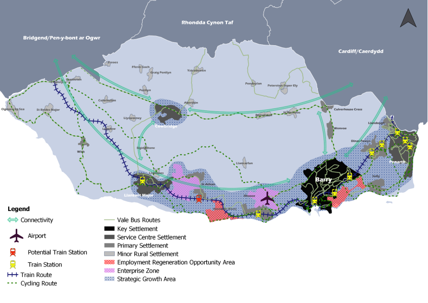
Figure 12: Key Diagram
STRATEGIC POLICIES
6.38 This section sets out the overarching strategic policies that address the key themes identified and also contribute to delivering the vision and objectives. The policies have been arranged into the four themes of Planning Policy Wales:
- Strategic and Spatial Choices
- Active and Social Places
- Productive and Enterprising Places
- Distinctive and Natural Places
STRATEGIC AND SPATIAL CHOICES
PREFERRED GROWTH STRATEGY
6.39 Policy SP1 sets out the level of growth and its spatial distribution in accordance with the RLDP Sustainable Growth Strategy.
The Vale of Glamorgan RLDP will make provision for the following in the period 2021-2036:
Housing
The delivery of 7,890 dwellings by 2036, including a minimum of 2,000 affordable homes. The primary focus of housing and employment growth within the Vale shall be within the Strategic Growth Area as identified on the Key Diagram and will be concentrated in the following locations that are served by existing public transport routes and provide the opportunity to enhance sustainable transport connectivity:
A. Barry
B. Penarth
C. Llantwit Major
D. Cowbridge
E. Dinas Powys
F. Rhoose
G. St Athan
In rural areas, additional growth will be permitted within existing settlement boundaries and on affordable housing led schemes in sustainable locations.
Employment
Employment sites to deliver the identified employment land requirement 67.8ha and the delivery of up to 5,388 jobs. New employment development will be focussed on existing Major and Locally Important Employment Sites and Employment Regeneration Opportunity Areas.
Infrastructure
Deliver associated infrastructure necessary to support the growth.
SETTLEMENT HIERARCHY
6.40 To ensure that new development takes place in locations that have the best access to a wide range of services, facilities, and employment opportunities, whilst minimising the need to travel, the distribution of growth is guided by the following settlement hierarchy. This position of each settlement within the hierarchy has been informed by an assessment of population size, settlement connectivity, and the availability of employment and other services and facilities as detailed in the Council's Settlements Appraisal Review.
The broad distribution of development within the Strategic Growth Area will be shaped by the following hierarchy of settlements, reflecting the role and function of places, and directing growth to locations that will provide the greatest opportunities for delivering housing to meet affordable needs, community infrastructure and enhanced sustainable transport provision.
Strategic Growth Area Settlement Hierarchy:
Key Settlement: Barry.
Barry will remain the focus of future development within the Vale of Glamorgan. As the largest town within the Vale, future growth will support its role as the main administrative town providing good transport connectivity, services, employment and retail and leisure for its residents and wider area.
Service Centre Settlements: Cowbridge, Llantwit Major, Penarth.
These areimportant settlements that offer a range of facilities that also serve a wider area. Future growth will support this role where the level of development will meet local needs of the area.
Primary Settlements: Rhoose, St Athan, Sully, Llandough, Dinas Powys
Development within these settlements will reflect the complimentary role they have in relation to the Key and Service Centre Settlements, transport connectivity and areas of employment.
Areas Outside the Strategic Growth Area
Primary Settlements: Wenvoe, Wick, Culverhouse Cross
Minor Rural Settlements: Ewenny, Corntown, St Brides Major, Colwinston, St Nicholas, Bonvilston, Fferm Goch, Peterston Super Ely, Llandow, Ystradowen, Llanmaes, Pendoylan, Aberthin, Llancarfan, Llysworney, Graig Penllyn, Ogmore by Sea, Sigingstone, Aberthaw East, Penllyn, Treoes.
The character of the settlements, including their relationship to and setting within the surrounding countryside, will be protected and where possible enhanced. Development in the Primary Settlements that are outside of the strategic growth area as well as the Minor Rural Settlements identified will be limited to the efficient and sustainable use of existing buildings, infill opportunities, small-scale affordable housing led schemes, and rural enterprise/ agricultural related developments.
For the purposes of this policy small scale affordable housing led developments are defined as providing a minimum of 50% affordable housing on sites of up to 25 dwellings in minor rural settlements or up to 50 dwellings in primary settlements. The type, scale and mix of affordable housing will be expected to reflect the latest evidence, including specialist older person housing. Proposals which do not meet the minimum 50% affordable housing provision will not be supported.
The settlements identified within the settlement hierarchy have been afforded settlement boundaries. Outside of these defined settlement boundaries are regarded as 'countryside' unless specifically identified for other uses in the plan.
6.41 The spatial growth strategy for the Vale provides the framework for delivering growth that will support and reflect the different roles and functions of its towns and villages and the needs of communities, linked by sustainable transport choices. Delivering Placemaking also requires growth to respect the scale and function of places, safeguard environmental quality, and enhance local character.
6.42 Policy SP2 identifies the hierarchy of settlements within the Vale of Glamorgan, reflecting the Strategic Growth Area of the Plan. Within the Growth Area, the Strategy directs growth to the Key, Service Centre and Primary Settlements located within the Strategic Growth Area. As well as providing opportunities for sustainable regeneration and support local service provision and to encourage the use of sustainable travel modes, future growth shall also reflect their respective roles and characteristics as well as their relevant physical or environmental constraints.
Strategic Growth Area Settlements
6.43 The Key Settlement of Barry will continue to be an important hub for social and economic activity and is recognised in the Strategy as one of the most sustainable locations within which to focus major new development opportunities. Barry has experienced major growth during the previous plan period, including through the mixed-use redevelopment of Barry Waterfront, which was identified as a strategic site within the adopted LDP up to 2026. Development opportunities for a mix of uses remain within the wider Barry Waterfront area on a number of smaller sites, but in order to meet the significant need for affordable housing and to respond to Barry's position as a Key Settlement, there is a need to identify additional housing in the town supported by a range of other complementary uses.
6.44 The Service Centre settlements of Cowbridge, Penarth and Llantwit Major are all different in character, but have similar roles. For example, they all have significant resident populations, good public transport provision, local employment opportunities, established town centres and a wide range of cultural, educational and community services and facilities. The Service Centre settlements serve the daily needs of their residents and act as important hubs for those living in nearby smaller settlements. Therefore, the strategy envisages that these settlements will also act as focal points for growth in the Vale of Glamorgan over the Plan period.
6.45 Dinas Powys, Llandough (Penarth) and Sully are defined as Primary Settlements and provide a complimentary role to the key and service centre settlements in that they provide for the needs of residents. They contain several key services and facilities, vital to their role as sustainable communities, and are well served by regular public transport services. These facilities include primary schools, small convenience shops, food and drink outlets and employment opportunities.
6.46 St. Athan and Rhoose are key locations for employment growth within the Strategic Growth Area. The two settlements are identified as Primary Settlements, reflecting the range of services and facilities available. Future growth within these settlements would accords their roles within the wider regional growth area due to their proximity to the Bro Tathan and Cardiff Airport Enterprise Zones and the proposed Aberthaw Green Energy Park, as well as existing and future transport connectivity proposals.
Settlements outside the Strategic Growth Areas
6.47 The settlements of Wick, Wenvoe and Culverhouse Cross have been identified as Primary Settlements as part of the Settlements Appraisal Review as the size of settlements and the services and facilities available are commensurate with other Primary Settlements of a similar scale. However, these specific settlements have purposefully not been included within the Strategic Growth Area as significant additional growth within these settlements would be contrary to the RLDP Strategy. In the case of Wick, this is due to the rural location of the settlement and the limited opportunities to travel by means other than the car for employment and to access services and facilities.
6.48 Whilst Culverhouse Cross and Wenvoe are not on existing train lines, they are served by regular bus services. Culverhouse Cross has changed in character over the adopted plan period, with the redevelopment of the former ITV studios resulting in the settlement having a more residential role, alongside its position as an out-of-town retailing centre. Whilst there are a range of A1, A3 and D2 uses in close proximity, it lacks any community facilities including schools and healthcare and further residential development in this area would therefore have the potential to increase car use. Furthermore, the Spatial Options paper also identifies that development opportunities in both Culverhouse Cross and Wenvoe are significantly limited by the presence of Best and Most Versatile (BMV) agricultural on the edge of both settlements.
6.49 The Vale's Minor Rural Settlement have also been identified outside of the Strategic Growth Area. The types of services and facilities typically found within these smaller settlements includes places of worship, community halls, small scale retail uses and formal recreational facilities. Several of the smaller rural settlements such as Colwinston, St Nicholas and St. Brides Major include primary schools that serve a wider catchment area, whilst others also provide small scale local employment opportunities, either within or near settlements. Due to these functional links between rural settlements, it is essential to ensure that existing services and facilities are safeguarded, and that enable opportunities that will support or enhance facilities.
6.50 Notwithstanding this, it is essential for the LDP to balance the growth in a way that supports the needs of rural communities with the wider sustainability objectives of the plan, especially in its contribution towards meeting the challenges posed by climate change. Consequently, Policy SP2 identifies those settlements that are considered to have sufficient population, services and facilities to accommodate small scale growth without it having a detrimental impact on their existing character and local environment.
6.51 Consistent with national policy, within these settlements general market housing will be limited to opportunities within the defined settlement boundaries, including infill development and the conversion of existing buildings. Elsewhere, new housing development on the edge of these villages will be restricted to 'rural exceptions' housing where a functional need is evidenced, and to small scale affordable housing led allocations (up to 25 dwellings in minor rural settlements and up to 50 dwellings in primary settlements outside the strategic growth area), where a minimum of 50% affordable housing will be required.
6.52 Enabling an element of open market housing within rural villages will provide opportunities for the delivery of affordable housing and market housing reflecting the aspirations of rural communities to sustain and provide for their housing needs and support viability and deliverability. In this regard proposals which cannot deliver a minimum 50% affordable housing shall not be permitted.
6.53 Given the diverse character of the rural villages identified in Policy SP2, in considering the scale of affordable housing need proposed, the Council will take account of the suitability of the proposal in relation to exiting services and facilities, availability of public transport and the impact the proposal would have on character and setting of the village. In this respect, proposals should be led by Placemaking principles set out in Policy SP5, rather than by a desire to maximise the number of dwellings set out in the policy.
6.54 Settlement boundaries will be drawn around each of the towns and villages in the RLDP settlement hierarchy at Deposit stage and will be clearly defined on the Proposals Map. Settlement boundaries play an important role in ensuring the delivery of sustainable development by encouraging development within the sustainable settlements identified in the LDP Hierarchy. They also assist in protecting the surrounding undeveloped countryside from inappropriate development, in line with national planning policy, by delineating the extent of built development. The delineation of settlement boundaries therefore helps to support and reinforce the delivery of the Plan's objectives and strategy and provides a key policy mechanism for managing growth within the Vale of Glamorgan.
HOUSING GROWTH
6.55 The RLDP strategy for housing growth seeks to bring forward sufficient housing to meet the identified housing requirement of the preferred growth option for the plan over the plan period, ensuring that an appropriate mix is provided of general needs market and affordable homes, and specialist housing to cater for the needs of those in need of accessible or adapted housing.
To meet the identified housing requirement of 7,890 dwellings, provision will be made for the delivery of 8,679 homes in the Plan Period 2021 to 2036. This will be delivered by:
- 4,457 dwellings from the existing land supply
- 1,603 dwellings from large and small windfall developments
- 2,450 to 2,750 dwellings on key sites*
- Additional new housing allocations including affordable led developments*
*Exact numbers of units to be determined at Deposit RLDP stage
6.56 Policy SP3 identifies a housing requirement of 7,890 dwellings (526 units per annum) for the plan period. With the inclusion of a 10% margin for flexibility to ensure deliverability, the plan will make provision for 8,679 dwellings. This housing provision will be delivered from the component sources listed in Table 2.
6.57 In order to meet this housing requirement figure, the Council has taken into account the contribution of the existing land supply, i.e., sites with planning permission, including those units under construction, and existing adopted LDP sites which are considered to be both deliverable and viable, and complement the spatial growth strategy of the RLDP. This figure also includes units that have been completed on large and small sites over the first 2 years of the plan period, equating to 785 dwellings. Collectively these sources would contribute 4,457 dwellings towards meeting the housing requirement. Appendix 1 provides a list of all sites with planning permission and Appendix 2 sets out the deliverable adopted LDP sites that are proposed to be rolled forward.
6.58 A further source of housing arises from windfall developments, which are sites that are not specifically allocated for housing yet come forward in accordance with the development plan and other material planning considerations. Analysis of historical delivery of housing over the past 10 years indicates that on average small windfall sites (sites of less than 10 dwellings) have provided some 55 dwelling completions per year, and large windfall sites (10 dwellings or greater) contributed on average 74 dwellings per year. After consideration of existing large windfall sites within the existing housing land supply and the contribution that these sources have already made during the first two years of the RLDP, it has been projected that windfall sites would potentially contribute a further 1,603 dwellings over the remainder of the plan.
6.59 Table 2 below draws the above elements together to identify the existing housing supply against the housing requirement and consequently identifies the future requirement to be met through new site allocations in the RLDP. Taken together these sources contribute 6,060 dwellings towards the RLDP housing requirement of 8,679 dwellings, leaving a residual housing requirement of 2,619 dwellings to be provided through additional allocations within the RLDP.
|
Table 2: Housing Supply and Housing Requirement |
|||
|
Component of Supply |
Number of Dwellings |
Notes |
|
|
Housing Provision |
8,679 |
Housing requirement for 2021-2036 (7,890 dwellings + 789 (10%) flexibility allowance) |
|
|
A |
Completions 21/22 and 22/23 |
785 |
Comprising 700 dwellings on large sites and 85 dwellings on small sites |
|
B |
Units under construction 1st April 2023 |
513 |
|
|
C |
Units within planning permission |
1,449 |
Includes sites that have S106 agreements pending where it is realistic that the agreement will be signed |
|
D |
Rolled forward LDP sites |
1,710 |
Only those that are realistically likely to be developed – some are subject to planning applications |
|
Total Existing Supply (A+B+C+D) |
4,457 |
||
|
E |
Large Sites Windfall Allowance (10 or more dwellings): |
888 (74 dwellings p.a. x 12 years) |
A large sites windfall allowance of 74 dwellings p.a. is forecast over the plan period. To avoid double counting of large windfall sites already within the land supply, this allowance has been applied to 12 of the remaining years of the plan 2024-2026 |
|
F |
Small Sites Windfall Allowance (9 or less dwellings): |
715 (55 dwellings p.a. x 13 years) |
An allowance of 55 dwellings p.a. has been included, which is based on an average of small site completions over the last 10 Years. This allowance has been applied to remaining years of the plan 2023-2026. |
|
Total Windfall allowance (E+F) |
1,603 |
||
|
Residual Requirement (Additional land to be allocated on new sites) |
2,619 |
Housing provision minus total existing supply minus total windfall allowance |
|
6.60 Further details of the Council's analysis of the Vale of Glamorgan land supply are set out in the RLDP Housing Land Supply Background Paper.
HOUSING DELIVERY
6.61 Strategic Policies SP1 and SP3 identifies the requirement for the provision of an additional 7,890 dwellings over the plan period, and the plan makes provision for 10% allowance to provide a degree of flexibility to ensure delivery of the requirement and equates to a total provision of 8,769 dwellings.This figure will be met through the existing land supply detailed in Table 2 plus the allocation of key sites as listed in Policy SP4 and additional affordable housing led sites, which will be identified at Deposit Plan stage when further detailed assessment work is complete.
6.62 Planning Policy Wales identifies a search sequence for the allocation of land with previously developed (brownfield) and under-utilised sites being considered in the first instance. There are limited opportunities for further significant brownfield development in the Vale of Glamorgan and therefore it is necessary to target development in the most sustainable locations on the edge of settlements that can be well connected by active travel routes to public transport, services and facilities. The RLDP will seek to allocate those sites that are in the most sustainable locations and can deliver high quality development in accordance with placemaking principles and that respond positively to the nature and climate emergencies.
6.63 The Key Sites that are identified in Policy SP4 have been selected following a robust multi-stage assessment process in line with the Candidate Site Assessment Methodology. The process has considered the suitability of the sites for development have regard for an initial appraisal of site constraints and deliverability as well as conformity with the Preferred Strategy. At Preferred Strategy stage, only sites considered key to the delivery of the strategy have been identified. These key sites are located in settlements in the highest tiers of the settlement hierarchy within the strategic growth area and are of a sufficient scale to be able to best deliver placemaking principles including delivering a mix of uses, green infrastructure and active travel improvements. The key sites are also all within a 20-minute walk or cycle to existing or proposed rail stations.
To deliver the plan's strategic growth and contribute to meeting the identified housing requirement set out in SP3, additional land is identified for residential development within the following key locations:
Key Sites
Site Reference
Settlement
Site Name
Dwellings proposed in plan period
SP4 KS1
Barry
Land at North East Barry
900
SP4 KS2
Dinas Powys
North of Dinas Powys, off Cardiff Road
250
SP4 KS3
Rhoose
Land at Readers Way
450
SP4 KS4
St Athan
Land at Church Farm, St Athan
250-550
SP4 KS5
St Athan
Land to the West of St Athan
600
-
-
-
2,450 - 2,750
Strategic Growth Area Land Bank Sites - Committed and Rolled Forward Housing Sites
Reference
Settlement
Site Name
Status
Dwellings Remaining 1st April 2023
Llantwit Major
Land between new Northern Access Road and Eglwys Brewis Road (east)
Rolled forward Adopted LDP allocation
185
Llantwit Major
Land between the Northern Access Road and Eglwys Brewis Road (west)
Planning permission (subject to s106)
140
Llandough
Land south of Llandough Hill / Penarth Road
Planning permission (subject to s106)
133
Rhoose
Land north of the Railway Line, (East)
Planning application awaiting determination
282
-
-
-
Total
2,589
In delivering the housing requirement, all new residential developments will be required to contribute towards the provision of an appropriate mix of market housing, affordable housing, specialist accommodation and support the transition to zero carbon.
6.64 To deliver this housing requirement, Policy SP4 identifies the Key and Strategic Growth Area Housing Allocations that will contribute towards meeting the majority of the housing requirement over the plan period. These consist of new Key Sites allocations and Strategic Growth Area Land Bank Sites Committed and Rolled Forward Sites (i.e., sites with planning permission and/or existing allocated sites that are realistically likely to be delivered in the RLDP plan period). Only those sites that can accommodate 50 dwellings or more is included within the list above as these will make the most significant contribution towards delivering the strategy. In addition to this, there are sites that benefit from planning permission but have not been included within the list above due to their smaller scale (less than 50 dwellings) or because they are located outside of the Strategic Growth Area. The full list of sites with planning permission is set out in Appendix 1.
6.65 Further consideration of the Key Sites in terms of housing, community facilities, sustainable transport and infrastructure requirements for each of the sites are set out in site specific policies SP4 KS1 to SP4 KS5 and Appendix 3.
6.66 For existing Strategic Growth Area sites with planning permission, allocations will be expected to be delivered in accordance with their current permissions. Existing LDP housing allocations will be required to comply with all other relevant policies of the current LDP until such time as the RLDP is adopted, after which, sites will be required to comply with the policies of the RLDP including those relating to the provision of affordable housing, active travel, placemaking and design and provision of green infrastructure.
Spatial Distribution of Housing Growth
6.67 The table below summarises the spatial distribution of the various components of the housing land supply as they relate to the RLDP Settlement Hierarchy. The table indicates that 785 dwellings have already been constructed since the commencement of the plan period and that the existing housing land bank will contribute to a large proportion of the identified housing requirement. The distribution of windfalls across the settlement hierarchy shown in the table is representative of historical trends which indicate that most windfall development has come from sites within Barry and the Service Centres of Cowbridge, Llantwit Major and Penarth, and the projected allowance reflects this trend. Further details of the Council's analysis of windfall trends are set out in the RLDP Housing Land Supply Paper.
|
Table 3: Spatial Distribution of Existing Housing Supply (April 2023) |
|||||||
|
Components of Housing Supply |
Settlement Hierarchy |
||||||
|
A |
Total |
Key Settlement Barry |
Service Centre Settlements |
Primary Settlements in Strategic Growth Area |
Minor Rural Settlements and Primary Settlements outside of Strategic Growth Area |
Hamlets and Smaller Rural Settlements |
|
|
Small Windfall |
85 |
33 |
23 |
22 |
5 |
2 |
|
|
Large (Windfall) and Allocations |
700 |
268 |
102 |
303 |
27 |
0 |
|
|
B |
Units under Construction April 2023 |
513 |
261 |
99 |
145 |
8 |
0 |
|
C |
*Units with Planning permission Not Started (April 2023) |
1449 |
153 |
608 |
561 |
111 |
16 |
|
D |
LDP Sites carried forward |
1710 |
135 |
938 |
637 |
0 |
0 |
|
E |
Key Housing Allocations |
2,450-2,750 |
900 |
0 |
1,550 – 1,850 |
0 |
0 |
|
F |
Additional Housing and Affordable Housing Led Allocations |
TBC |
TBC |
TBC |
TBC |
TBC |
TBC |
|
G |
Large windfall sites (10>) |
888 |
359 |
272 |
126 |
64 |
67 |
|
H |
Small windfall sites (<10) |
715 |
290 |
218 |
102 |
51 |
54 |
|
I |
Total Housing Provision |
2,399 |
2,260 |
3,446-3,746 |
266 |
139 |
|
|
Total Provision |
8,510 – 8,810 |
||||||
6.68 The spatial distribution of the housing land supply in Table 3 illustrates that the spatial distribution of new housing is being directed in line with the spatial growth strategy (SP1), specifically to the settlements in the Vale that are best served by public transport connectivity and offer a good range of services and facilities. Barry, as a key settlement, is accommodating a significant proportion of new development commensurate with its status in the hierarchy and its credentials as a sustainable settlement well served by sustainable transport. The service centre settlements are also accommodating an appropriate share. Whilst the highest proportion of development is identified within the primary settlements within the strategic growth area, it should be noted that there are five settlements within this category – St Athan, Rhoose, Dinas Powys, Llandough and Sully. These are settlements that as well as having good existing and proposed public transport links, are also well served by employment opportunities in close proximity, aligning housing with employment. It will be noted that only a small proportion of development is likely to take place outside of the strategic growth area, with some of this development relating to planning permissions granted in accordance with the adopted LDP strategy.
6.69 In the short-term the housing delivery will be more dependent on the supply of existing commitments and adopted plan allocations carried forward into the RLDP. However, as the plan period progresses, the contribution from new allocations will be more significant. A housing trajectory identifying the delivery of units will be prepared to support the Deposit LDP.
Key site details
6.70 Following the candidate site assessment process undertaken to inform the Preferred Strategy, the sites identified as Key Sites are those that are considered to best accord with the principles of the Preferred Strategy due to their locations in close proximity to sustainable transport links, services and facilities and are sites that are considered to be viable and deliverable, having regard for constraints. Whilst illustrative layouts have been provided for each site, further detailed assessment work will be undertaken in the lead up to the Deposit Plan including detailed Masterplans and a detailed list of development requirements. The overall capacity of sites and the affordable housing target may be subject to change in light of the masterplanning process and detailed viability work.
Land in North East Barry is allocated for a residential led development comprising residential, community facilities including a primary school, commercial uses, green infrastructure and leisure facilities and improved active travel routes. The site will accommodate up to 1,500 dwellings, of which 900 dwellings would be delivered during the Plan period.
The developer will be required to provide the following:
- A minimum of 30% of affordable housing, subject to consideration of viability.
- On and off-site measures to provide good quality, attractive, legible, safe and accessible pedestrian and cycle linkages to local services, facilities and public transport nodes, including to Cadoxton Station and along the A4231 Barry Docks Link Road.
- The delivery of a village centre encompassing an appropriate mix of uses to be determined through the Masterplanning process.
- The on-site provision of education facilities.
- Improvements to infrastructure, including the upgrading of highways, pedestrian and cycle access from Gilbert Lane and Argae Lane.
- The provision and enhancement of appropriate green infrastructure, leisure, sport and recreation space together with biodiversity enhancement to achieve biodiversity net benefit.
- Other planning obligations as necessary in accordance with Policy SP12 to be determined through the Masterplanning process.
Figure 13: SP4 KS1 Land at North East Barry initial illustrative plan

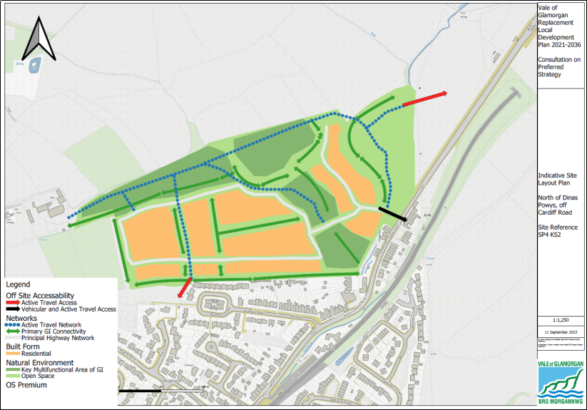
SP4 KS2 LAND TO THE NORTH OF DINAS POWYS, OFF CARDIFF ROAD
Land to the North of Dinas Powys is allocated for a comprehensive residential led development of 250 homes during the Plan period.
The developer will be required to provide the following:
- A minimum of 40% of affordable housing, subject to consideration of viability.
- On and off-site measures to provide good quality, attractive, legible, safe and accessible pedestrian and cycle linkages to local services, facilities and public transport nodes, including Eastbrook Station.
- Improvements to infrastructure, including the upgrading of highways, pedestrian and cycle access on to Cardiff Road.
- The provision and enhancement of appropriate green infrastructure, leisure, sport and recreation space together with biodiversity enhancement to achieve biodiversity net benefit.
- Other planning obligations as necessary in accordance with Policy SP12 to be determined through the Masterplanning process.
Figure 14: SP4 KS2 Land North of Dinas Powys, Off Cardiff Road, Dinas Powys initial illustrative plan
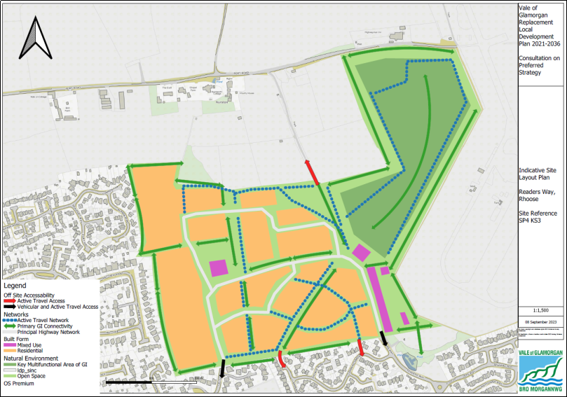
SP4 KS3 LAND AT READERS WAY RHOOSE
Land at Readers Way, Rhoose is allocated for a comprehensive, residential led development of 450 homes during the Plan period. A minimum of 35% of all new homes will be required to be affordable.
The developer will be required to provide the following:
- A minimum of 35% of affordable housing, subject to consideration of viability.
- On and off-site measures to provide good quality, attractive, legible, safe and accessible pedestrian and cycle linkages to local services, facilities and public transport nodes, including Rhoose Station.
- The delivery of an appropriate mix of uses to be determined through the Masterplanning process.
- Improvements to infrastructure, including the upgrading of highways, pedestrian and cycle access to serve the site.
- The provision and enhancement of appropriate green infrastructure, leisure, sport and recreation space together with biodiversity enhancement to achieve biodiversity net benefit.
- Other planning obligations as necessary in accordance with Policy SP12 to be determined through the Masterplanning process.
Figure 15: SP4 KS3 Land at Readers Way, Rhoose initial illustrative plan
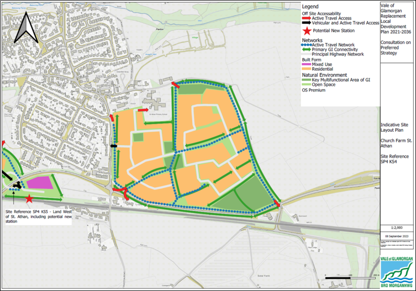
SP4 KS4 LAND AT CHURCH FARM, ST ATHAN
Land at Church Farm, St Athan is allocated for a comprehensive residential led, development of between 250 and 550 homes during the Plan period. A minimum of 35% of all new homes will be required to be affordable.
The developer will be required to provide the following:
- A minimum of 35% of affordable housing, subject to consideration of viability.
- On and off-site measures to provide good quality, attractive, legible, safe and accessible pedestrian and cycle linkages to local services, facilities and public transport nodes.
- The delivery of an appropriate mix of uses to be determined through the Masterplanning process.
- Improvements to infrastructure, including the upgrading of highways, pedestrian and cycle access to serve the site.
- The provision and enhancement of appropriate green infrastructure, leisure, sport and recreation space together with biodiversity enhancement to achieve biodiversity net benefit.
- Other planning obligations as necessary in accordance with Policy SP12 to be determined through the Masterplanning process. This may include a contribution towards the delivery of a new station at St Athan.
Figure 16: SP4 KS4 Land at Church Farm, St Athan initial illustrative plan
SP4 KS5 LAND TO THE WEST OF ST ATHAN
Land to West of St Athan is allocated for a comprehensive, residential led development of 600 homes during the Plan period. A minimum of 35% of all new homes will be required to be affordable.
The developer will be required to provide the following:
- A minimum of 35% of affordable housing, subject to consideration of viability.
- On and off-site measures to provide good quality, attractive, legible, safe and accessible pedestrian and cycle linkages to local services, facilities and public transport nodes.
- The delivery of an appropriate mix of uses to be determined through the Masterplanning process.
- Improvements to infrastructure, including the upgrading of highways, pedestrian and cycle access to serve the site.
- The provision and enhancement of appropriate green infrastructure, leisure, sport and recreation space together with biodiversity enhancement to achieve biodiversity net benefit.
- Other planning obligations as necessary in accordance with Policy SP12 to be determined through the Masterplanning process. This may include a contribution towards the delivery of a new station at St Athan.
Figure 17: SP4 KS5 Land to the west of St Athan initial illustrative plan

QUESTION 8: KEY SITES
The five key residential led sites identified in the Preferred Strategy will help meet the housing requirement over the Plan period. Do you agree with the five key sites identified? (please state which key site your comments relate to).
ACTIVE AND SOCIAL PLACES
PLACEMAKING
6.71 Placemaking is a cornerstone of the national planning agenda in Wales and the sustainable development objectives which underpin it. It is a multi-faceted approach to the planning, design and management of new development and spaces, as well as the protection and enhancement of existing assets. It is fundamentally about responding to the context of a place, through an understanding of its evolution, its functionality, and its impacts.
Development proposals will be required to demonstrate the following Placemaking Principles which will add social, economic, environmental, and cultural value, resulting in enhanced local benefits by:
A. Ensuring high quality sustainable design that reflects local distinctiveness, character, and cultural identity;
B. Prioritising the determinants of health and well-being during the design process;
C. Creating a diverse mix of uses and multi-functional spaces;
D. Contributing to a vibrant, safe and inclusive public realm that encourages active travel and reduces car dependency;
E. Strategically integrating Green Infrastructure networks and open space into development, delivering social and environmental benefits;
F. Providing a range of housing types and tenure;
G. Locating development appropriately where homes, local services and facilities are accessible and well connected;
H. Developing high densities where appropriate, making the most efficient use of land and supporting mixed uses;
I. Protecting and enhancing the Historic Environment.
Placemaking Statements will be required for all major developments setting out how the proposal accords with Placemaking Principles.
6.72 The Council is committed to the Placemaking Wales Charter and recognises Placemaking as fundamental in achieving the RLDP Vision. The purpose of Policy SP5 is to ensure that Placemaking is achieved by any new development through the application of the Placemaking Principles.
6.73 Placemaking is defined by the Design Commission for Wales (DCFW) in the Placemaking Guide (2020) as "ensuring that each new development or intervention contributes positively to creating or enhancing environments within which people, communities, businesses and nature can thrive". Assessing proposals for new development requires a holistic approach that takes into consideration whole places rather than individual land uses or each development in isolation. Placemaking relates to the built and natural environment and involves considerations at a high level, including climate change, down to local level such as impact on local character and cultural identity, including the impact on the Welsh language.
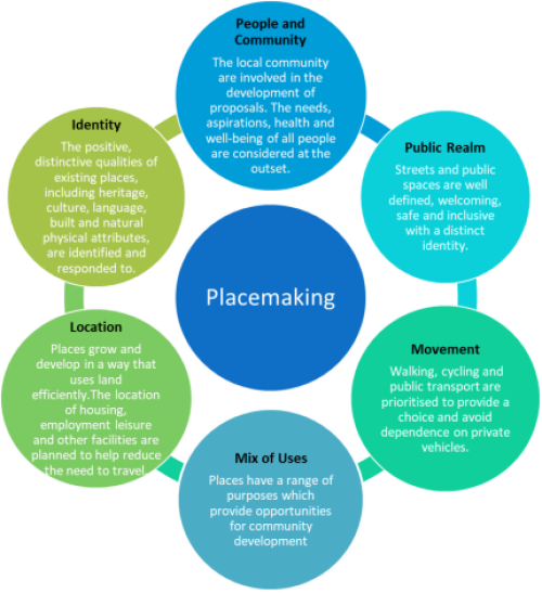
Figure 18: Placemaking Principles
Source: Design Commission for Wales
6.74 Implementation of the Placemaking Principles will ensure that well-being is maximised through sustainable development that promotes active and healthy lifestyles. The determinants of health and well-being, as set out under Policy SP12 Health and Well-being, must also be considered as a priority from the early design stage, and demonstrated clearly by development proposals. High standards of design will create attractive places with distinct local identity and a vibrant public realm offering accessibility for all, focused on hubs of mixed used development that is connected and well served by active travel and public transport.
6.75 The Vale is rich with local character, heritage and natural beauty which must be respected and enhanced by new development. Development proposals must demonstrate considerate design, which is sustainable, minimises environmental impact and responds visually to its surroundings. As well as vibrant and attractive, the public realm must be accessible and inclusive for all. Proposals for public realm improvements should consider measures to assist people with physical or sensory impairments.
6.76 New development within the Vale should contribute to places with a variety of uses, services and facilities, where people can live, work and enjoy. Housing developments must offer a range of housing types and tenure to accommodate a range of needs and be in sustainable locations where there is access to a variety of uses. A mix of uses helps to create places that are inviting and sustainable; offering positive interactions between people, businesses and the environment, and reduces the need to travel. Developing to high densities will make the most effective use of land, maximise development potential, improve connectivity and encourage active travel.
6.77 Multi-functional spaces include public open space, streets or mixed-use buildings which offer safe and welcoming space for people to interact, socialise, work, exercise or relax. Green Infrastructure should be integrated into public spaces to improve visual quality, add amenity value, encourage physical activity and interaction with nature as well as sustainable drainage and ecological benefits.
6.78 Development will be favoured where meaningful community involvement has been demonstrated. Engagement with local people where they have the opportunity to contribute to development proposals is valuable for placemaking as it creates a sense of ownership and belonging amongst communities.
6.79 Major development proposals must be supported by a Placemaking Statement to demonstrate clearly how proposals for new development will achieve placemaking. Placemaking Statements will explain the aspects of the development and measures taken to ensure that the proposal accords with the Placemaking Principles. Evidence should be included to demonstrate how each Placemaking Principle has been met.
HEALTH AND WELL-BEING
6.80 The health and well-being of our communities is crucially important to delivering long term sustainable development and placemaking. This includes physical, mental and social well-being. Key to the Plan is ensuring access to good quality services and facilities exists and that people of all ages and backgrounds receive the access they need to live full, productive and prosperous lives.
6.81 Planning and health need to be considered together in two ways: in terms of creating environments that support and encourage healthy lifestyles, and in terms of identifying and securing the facilities needed for primary, secondary and tertiary care, and the wider health and care system.
SP6 – CREATING HEALTHY AND INCLUSIVE PLACES AND SPACES
All development shall seek to create healthy and inclusive places that improve health inequities and social cohesion. This will be achieved by:
A. Ensuring development proposals are designed to facilitate accessible healthy environments to address relevant determinants of health positively, particularly in response to local health needs.
B. Ensuring that all places and developments are as inclusive as possible, capable of adapting to a broad range of changing needs and delivering a high quality of life, where no one is excluded.
C. Enabling Opportunities for access to healthy food choices
D. Supporting the provision of new and enhanced community and healthcare facilities.
E. Protecting existing public health and well-being.
Major Developments will be required to be accompanied by Health Impact Assessments to fully consider their health implications.
6.82 Policy SP6 seeks to ensure that development proposals promote health and well-being. Whilst many of the complexities of promoting health and well-being exist beyond the remit of the planning system, it is recognised that the quality of the environment that we inhabit and the activities that take place within these spaces have crucial impacts on them. The wider determinants of health (Figure 19) illustrate the relationship and interactions between the built environment and physical and mental well-being.
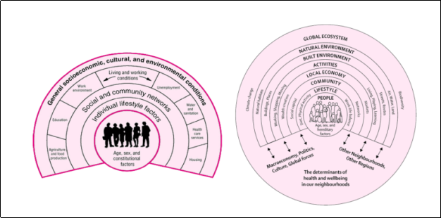
Figure 19: The Wider Determinants of Health
Source: Dahlgren and Whitehead (1991) R: Barton and Grant (2006)
6.83 To ensure new development responds appropriately to health and well-being needs, and tackles health inequalities, a health in all policies approach will be followed. This ensures that new policy considers its health implications by seeking to avoid negative health outcomes and improving them where possible. This embeds health and wellbeing as a key policy issue throughout all relevant policies within the plan and is underpinned by Policy SP6.
6.84 Healthy Places and Spaces are those which incorporate a high standard of design that responds to health and well-being needs of all users and the placemaking principles; facilitate high levels of multi-modal accessibility for all journeys to necessary services and facilities; the provision of quality active travel infrastructure and open spaces, including sport facilities; the provision of green infrastructure and spaces for socialising, including spaces for growing food; and high-quality and appropriate housing accommodation. Ensuring these will guarantee determinants of health affected by planning are addressed positively.
6.85 Inclusive places are those that deliver equality of accessibility and opportunity, enabling everyone to participate fully in society and people to remain in their homes and communities as their needs change. Relatively small modifications can have a significant impact on the ability of people to enjoy their local area, such as incorporating appropriate lighting to reduce the fear of crime, providing places for people to rest and socialise. Careful design can ensure that places are welcoming for all generations, removing barriers that prevent people from meeting their needs or enjoying active lives. In this respect there is considerable cross over between health and wellbeing and the delivery of placemaking as set out in Policy SP5.
6.86 The availability of local healthy, affordable food is associated with improved attitudes towards healthy eating and healthier food purchasing behaviour, as well as changes to dietary behaviour, such as increased fruit and vegetable consumption. The provision of areas for growing food within new development offers the opportunity for individuals and communities to have access to fresh fruit and vegetables, contributing to healthy lifestyles and encouraging physical activity.
6.87 Additionally, gardening and food growing can also contribute to mental wellbeing and social inclusion, and provide economic, environmental, and educational benefits. Depending on the proposal, the incorporation of areas for growing could count towards the provision of on-site open space requirement. The provision of allotments is the most common way to provide informal opportunities for local food production. However, where there is limited scope to provide designated outdoor growing spaces, creative solutions should be explored. Such measures could include the planting of fruit trees, the provision of containers and raised beds within landscaping schemes, the creation of growing spaces within communal gardens, internal courtyards and roof gardens, or by utilising incidental spaces. In larger developments this could also include areas of land unsuitable for buildings.
6.88 Health inequalities exist across the Vale of Glamorgan, both spatially and between different population groups. Compliance with Policy SP6 will ensure that where possible these health inequalities are addressed. Data sets that identify inequalities include the Welsh Index for Multiple Deprivation[6], and publications from Public Health Wales and Cardiff and the Vale University Health Board. These should be used to inform Health Impact Assessments (HIAs)
6.89 HIAs consider how the population will be affected by development, assessing both positive and negative health impacts. A key consideration of these is ensuring health inequalities are not increased by proposed developments. All development which falls under the threshold for undertaking a HIA, should still be designed to maximise the impact it can make to promoting healthy communities and reducing health inequalities. In these cases, where inequalities are identified, how a proposed development will achieve this should be set out in a planning statement.
6.90 HIAs will be required when assessing major developments (10 or more dwellings etc.) in order to consider their health implications. Guidance on completing HIAs has been produced by the Welsh Health Impact Assessment Unit[7]. Further guidance on the requirements for HIAs will be set out with Supplementary Planning Guidance.
6.91 An important contributing factor to poor diet and health is in the distribution and access to Food and Drink Uses, such as hot food takeaways, cafes and restaurants with a takeaway service. This is of particular relevance in areas of deprivation. In some locations there is an issue where such uses cluster together, reinforcing the ease of and access to unhealthy foods. Consideration will therefore be given to controlling the proliferation of, and therefore access to, such uses within the Vale's existing retail centres.
6.92 A further role of the RLDP will be supporting the provision of health care facilities, and whilst the Vale of Glamorgan Council does not directly deliver healthcare facilities the Council does have a key enabling role. Working in partnership with the Cardiff and Vale Local Health Board provides an understanding of service capacity, changes in service delivery and the need for additional facilities, the RLDP can facilitate and identifying opportunities for new and improved provision.
6.93 In consultation with local healthcare providers who deliver health infrastructure facilities in the Vale, developers of large housing developments (or where there are cumulative effects from a number of smaller developments), should have regard to whether there is a need to deliver appropriate health care facilities. The need for healthcare facilities, or other health-promoting infrastructure such as segregated cycle lanes or leisure facilities, should be considered in-step with the demands from new development. This is particularly necessary for large sites that may be phased during which time the demands created from a development may change.
6.94 It is also essential that development proposals safeguard public health and well-being, including the potential risks arising from climate change. In achieving this, development proposals must demonstrate that they will not result in an unacceptable impact on people and residential amenity, including from varying forms of pollution.
SUSTAINABLE TRANSPORT
6.95 The Vale of Glamorgan benefits from good transport connectivity by both rail and road that provides direct access to strategic network. However, the network experiences congestion at peak hours, leading to delays and the Council recognise the need for improvements to public transport services and walking and cycling infrastructure to encourage participation in active travel (walking and cycling) especially for shorter journeys within and between the Vale's towns and villages.
6.96 A key part of our strategy is to locate development in areas which are or can be made sustainable by encouraging a mix of uses within a development, limiting the need to travel, wherever possible, and offering a genuine choice with the priority being on walking, cycling and passenger transport. By decreasing reliance on private car use, such land use patterns will also help mitigate the ever-increasing threat of Climate Change by reducing greenhouse gas emissions.
To help address the RLDP Vision and Objectives, the Plan encourages a modal shift towards sustainable forms of transport and increasing active travel opportunities. New development must support an enhanced transport network that increases the proportion of journeys being undertaken by sustainable travel modes.
This will be achieved through:
-
- Appropriately siting new developments in sustainable and accessible locations where a range of services and facilities are within walking and cycling distance.
- Ensuring that new development is integrated with existing Active Travel Routes that provide a safe, inclusive, pleasant travelling experience, contributes to their expansion and improves connectivity within and between towns, villages and surrounding rural settlements.
- Ensuring that new developments are designed to encourage walking, cycling and public transport use as alternatives to private car use.
- Adopting appropriate levels of car and bicycle parking provision, reflecting the plans objectives for reducing car borne journeys in accordance with the Council's adopted parking standards
- Improving accessibility and connectivity to sustainable transport facilities.
- Providing new or enhanced transport services and facilities where appropriate.
- Supporting and facilitating the delivery of the South Wales Metro.
- Safeguarding former railway lines for potential and existing Active Travel routes.
- Providing the necessary infrastructure for ULEVs in appropriate locations.
- As appropriate, new development proposals will be required to provide Transport Statements, Transport Assessments and Travel Plans to ensure the delivery of travel choice and sustainable opportunities for travel.
- New developments anticipated to have an adverse impact on the transport network will be expected to contribute towards capacity and mitigation measures. Proposals that require new transport infrastructure will be required to make a proportionate financial contribution.
6.97 In light of the Sustainable Transport Hierarchy outlined in Planning Policy Wales (Edition 11) and the target included in Llwybr Newydd, the new Wales Transport Strategy 2021 for 45% of journeys to be made by public transport, walking and cycling by 2040, it is essential for the RLDP to include an ambitious strategic policy that addresses sustainable travel choices in the Vale of Glamorgan.
6.98 Policy SP7 sets out the plans approach for encouraging sustainable transport use, indicating that all new development proposals will be required to contribute to creating an accessible, sustainable, safe, integrated and well-connected transport network. This should be met both within and outside of the development area and proposals should demonstrate that transport provision associated with development proposals will be appropriate, both in terms of modal choice and the capacity of the highway network to accommodate additional trips for all modes.
6.99Active travel should be the natural first choice for everyday journeys and thus, all new development should prioritise walking, cycling and use of public transport at the earliest stages including how the proposal provides connectivity to existing areas and what opportunities are available for enhancing active travel connections. Developers should be able to demonstrate that transport provision associated with development proposals will be appropriate, both in terms of modal choice and the capacity of the highway network to accommodate additional trips for all modes.
6.100 It is also important that development is respectful of the existing scale and character of the area. The private vehicle requirements of the development should not have a significant adverse effect on the wider environment and the amenity of residents, such as through unacceptable levels of trip generation or result in displacement parking. Developers should be able to demonstrate that transport provision associated with development proposals will be appropriate, both in terms of modal choice and the capacity of the highway network to accommodate additional trips for all modes. If new developments are likely to have an adverse impact on the surrounding transportation network, they will be required to contribute towards improved capacity and mitigation measures.
6.101 New developments which are likely to result in significant transport impacts must be supported by Transport Statements, Transport Assessments and Travel Plans, as appropriate, to ensure the delivery of sustainable opportunities for travel in line with the latest Welsh Government guidance. A Transport Assessment provides detailed information on the likely transport impact of a proposed development and is submitted in support of a planning application; a Transport Statement is a lower level of assessment for smaller developments. Travel Plans are long-term management strategies for integrating sustainable travel proposals into the planning process and are often required where the proposal is required to be supported by a full Transport Assessment. The implementation of the Travel Plan will be secured as part of a planning permission.
6.102 The Council has adopted minimum parking standards within residential developments in order to overcome issues associated with low parking provision. In determining the right levels of parking, the Council will consider the anticipated demand from the type of housing proposed, the likely occupiers, the design of the public realm and highway, the proposed parking design solutions and any local restrictions.
AFFORDABLE AND SPECIALIST HOUSING
6.103 The delivery of affordable housing is a key objective of the LDP Strategy, with the relative strength of the Vale of Glamorgan's housing market over the last 10 years having resulted in many local people experiencing difficulties purchasing suitable housing on the open market.
6.104 The latest Local Housing Market Assessment (2021), published in January 2022, identifies that for the period 2021-2026, there is a need for 1,205 new affordable homes per annum. This comprises:
- 915 units of social rented accommodation
- 211 units of intermediate rented housing
- 79 units of low-cost home ownership
6.105 The existing backlog of need from people on the housing waiting list is most acute within Barry and Penarth/Llandough, although there are significant people on the waiting list across all areas of the Vale. Much of the need for affordable housing consists of smaller one and two-bedroom units for social rent across many parts of the Vale of Glamorgan, reflecting societal trends in household composition and the high prevalence of single person households and households comprising of couples with no children.
6.106 In March 2022, a new methodology for the preparation of LHMAs was published by Welsh Government with the requirement that emerging LDPs must now be based on the outputs of an LHMA prepared using the new methodology. The initial findings using version 3 of the toolkit (issued October 2023) indicate that there is a need for 1,121 net affordable homes per annum for the first 5 years of the plan period, and 204 homes per annum for the following 10 years. The need remains highest in Barry and Penarth/Llandough and the greatest need is for one and two bed social rented properties. It is intended that the final new methodology LHMA will be included as part of the evidence base for the Deposit Plan once signed off by Welsh Government.
6.107 To help address the need identified, the Council anticipates that the current land supply identified in SP3 together with new allocations will deliver a minimum of 2,000 affordable dwellings through the planning system over the plan period. The overall affordable housing target will depend on the viability of area specific targets and the spatial distribution of new and windfall sites and will therefore be revised for the Deposit LDP to take account of additional housing sites to be identified and to reflect updated viability evidence. Details on the affordable housing contributions from the existing housing land bank and those arising from the projected windfalls are set out in the Council's Housing Land Supply Background Paper.
SP8: AFFORDABLE AND SPECIALIST HOUSING
The residential requirement identified in Policy SP3 will be expected to contribute to the established community housing needs of the Vale of Glamorgan by delivering a minimum of 2,000 affordable residential units over the plan period.
In meeting this target, the plan will ensure that new housing developments provide for a mix of housing tenures, types, and sizes of homes, including specialist accommodation to meet the needs for residents with care needs and an ageing population, in accordance with the Council's latest Local Housing Marking Assessment and Older Persons Housing Strategy.
6.108 The Council's Older Persons Housing Strategy Creating Homes and Neighbourhoods for Later Life 2022-36 sets out a vision in the Vale of Glamorgan Council which is: 'to secure the best quality of life for older people to live as independently as possible in later life. This means delivering a range of accommodation that enables older people to live fulfilling lives and enjoy good health in attractive homes that meet their needs and allow them to retain their independence as they age".
6.109 The strategy projects that by 2037 there will be a need for some 1,357 specialist age designated housing, retirement housing (for social rent and for sale) and housing with care (extra care housing for social rent and for sale). Highlighting the importance for the Council and its partners to address future housing needs associated with an aging population through the provision of appropriate housing solutions arising from a growing older population. To address this forecast need, the strategy identifies a range of mechanisms for delivery including the LDP which is seen to have a key role in encouraging private and social housing providers to develop a range of mainstream housing that is suited and attractive to older people.
6.110 For these reasons, both Strategic Housing Policies SP3 and SP4 make provisions for new housing developments to include specialist housing such as older persons housing as part of the overall mix with residential developments, including where affordable housing is sought through planning contributions.
6.111 Housing for older persons covers a spectrum of needs, from sheltered housing (where residents live mainly independent lives whilst sharing some communal facilities) through to extra care housing and care homes, where a level of personal health care is typically provided. In addition to accommodation largely related to the needs of older people, there are other types of adapted accommodation that provide for other health-related needs. These would also fall within the provisions of this policy.
6.112 Further details on the mechanisms for delivering specialist housing will be set out in the Council's Affordable Housing Supplementary Planning Guidance.
Land will be made available to accommodate unmet Gypsy and Traveller accommodation identified in the latest Gypsy and Traveller Accommodation Assessment forthe provision of 11 residential pitches by 2036.
6.113 The Housing Act requires the Council to take account of the accommodation needs of the Gypsy and Traveller community through the preparation of the Gypsy and Traveller Accommodation Assessment (GTAA). The latest GTAA was completed in June 2022 and has been submitted to Welsh Government for approval. The GTAA has identified a need for 9 residential pitches in the five-year period up to 2026 and a further 2 pitches in remainder of the Replacement LDP plan period, giving a total need of 11 pitches until the end of Plan period.
6.114 There are currently retrospective planning applications in respect of four pitches across two sites, which form part of the unmet need. If these applications are approved, the unmet need figure will be reduced. There may also be scope to accommodate extra plots at one of the sites that are currently unauthorised (to meet the additional pitch need as the occupants' children become adults). This would further offset the need.
6.115 Land will be identified to accommodate any unmet Gypsy and Traveller accommodation need in the Deposit Plan. The Deposit Plan will also include a criteria-based policy against which to assess applications for new or unexpected demand for Gypsy and Traveller accommodation, including extensions to existing sites.
6.116 The GTAA also considers transit provision, recognising that there was a need for more transit provision in Wales, but it was identified there was no need to provide a transit site in the Vale based on current evidence. It is considered that transit provision is a regional issue and as such is being considered on a regional basis through the South East Wales Strategic Planning Group as part of the evidence base for the Strategic Development Plan.
RETAIL, COMMERCIAL AND SERVICE CENTRES
SP10: RETAIL, COMMERCIAL AND SERVICE CENTRES
The Hierarchy of Retail, Commercial and Service Centres within the Vale of Glamorgan is as follows:
Town Centres - Barry Holton Road, Penarth, Cowbridge
Town centres provides (or have the potential to provide) a range of shops, services, businesses, cultural, leisure and community facilities to a significant hinterland which includes smaller neighbouring towns or a number of suburbs.
District Centres - Barry High Street, Llantwit Major
District centres provide (or have the potential to provide) a range of shops, services, businesses and community facilities to a hinterland which includes neighbouring villages or a few surrounding suburbs.
Village and Local Centres - Barry: Main Street, Cadoxton; Vere Street, Cadoxton; Park Crescent; Barry Road, nr. Cadoxton; Upper Holton Road
Dinas Powys: Cardiff Road; Dinas Powys Village Centre
Penarth: Cornerswell Road
Rhoose: Fontygary Road
St Athan: The Square
Village and Local Centres provides (or have the potential to provide) essential shops and services to a surrounding community including nearby villages and hamlets.
Neighbourhood Centres - Barry: Bron-y-Mor; Cwm Talwg; Gibbonsdown Centre; Park Road
Boverton
Dinas Powys: Camms Corner; Castle Court/The Parade
Llantwit Major: Crawshay Drive
Penarth: Pill Street; Tennyson Road
Neighbourhood Centres provide (or have the potential to provide) essential shops and services to its immediate residential area)
The centres identified above are the preferred locations for a range of uses, including retail, leisure, office, visitor accommodation and appropriate residential and community facilities. Development proposals must be in keeping with the defined role of each centre.
New development within the Retail, Commercial and Service Centres should accord with the defined role of each centre within the hierarchy and support the vitality and viability and increase footfall within the centres.
6.117 The role of traditional town centres as retail centres is changing and their future regeneration and revival will involve repurposing to create multi-functional 'retail, commercial and service centres' that meet the needs of the community they serve. To recognise the need to move away from the traditional retail role of Town Centres and in accordance with Future Wales Town Centre First Policy, Policy SP9 adopts a more flexible approach to non-retail uses to create a mix of retail, commercial, leisure, residential etc. To maintain the long-term viability and vitality of the Vale's retail centres the plan will seek to enable them to evolve into multifunctional centres containing a broad range of retail, leisure and services that function as places and spaced for socialising, working, studying and enjoying.
6.118 Development proposals in Centres will apply the Placemaking Principles in Policy SP5, ensuring that Centres are attractive, safe and welcoming. Centres will be accessible for all and prioritise sustainable transport; they will be well served by active travel infrastructure and public transport that connects to surrounding settlements.
6.119 Centres are considered as sustainable places to live and where appropriate could incorporate small new scale residential development through, for example the conversion of upper floors. They should also include multifunctional open green spaces to improve amenity, visual quality and provide environmental and health benefits.
6.120 Barry (Holton Road), Penarth and Cowbridge are identified as Town Centres at the top of the hierarchy due to their large number and widest range of retail, leisure and services. Town Centres play an important role in their provision of retail and services as they serve surrounding and wider communities, which are well connected by sustainable transport. The range and number of retail, leisure and services and the significance of their wider role increases as Centres move up through the hierarchy from Neighbourhood Centres, Village Centres, District Centre and Town Centre.
6.121 Policy SP9 will need to be considered alongside detailed policies seeking to manage edge and out-of-town retailing.
New retail floorspace should be directed to the town and district centres identified in Policy SP10. There is capacity for between 4,282 and 5,862 sqm (net) of new convenience retail floorspace with the Vale of Glamorgan. Where quantitative and qualitative need has been evidenced and suitable sites are not available within the town and district centres, the sequential test will be followed. Where need is identified, proposals must conform with the requirements of relevant RLDP Policies.
6.122 Retail provision within the Vale of Glamorgan is largely concentrated within Barry town centre and Penarth, Cowbridge and Llantwit Major district centres. These retail areas are characterised by a range of local and national retailers and serve relatively wide catchment areas. In addition, local and neighbourhood centres provide an important local service for their immediate catchment area and provide opportunities for reducing journeys by car.
6.123 The latest Vale of Glamorgan Retail and Leisure Study (June 2023) provides an updated quantitative need and qualitative assessment of both convenience (food), comparison goods (clothing, electronic items etc.) and town centre leisure uses such as bars, cafes, and restaurants across the authority. The study identified that over the plan to 2036 there is qualitative capacity for between 4,282 and 5,862 sqm net of convenience food retail floorspace and 432 sqm net and 679 sqm net of comparison floorspace. Spatially, the study identifies the potential need for additional need convenience food retailing within the retail centres of Barry, Penarth and Llantwit Major which the report recommends would lead to potential improvements in the vitality and viability of these centres, whilst also recognising a general qualitative need for encouraging a diverse range of uses within the Vale's main town and district retail centres.
6.124 In considering proposals for additional convenience and comparison retail proposals the Council will consider how proposals contribute to national policy "Town Centres First" objectives to support diverse multifunctional centres that function beyond the traditional role of town shopping centers, expanding their role as places which offer opportunities to access range of shopping, commercial and leisure opportunities as well as places of employment, education, civic identity and social interaction.
INFRASTRUCTURE
6.125 Many forms of development place additional demands on services and facilities which will affect their ability to meet the needs of the community. The provision of new infrastructure, as well as the safeguarding, improvement and efficient use of existing infrastructure is central to ensuring that all new development proposed within the Plan period contributes to achieving the Plan's vision of creating sustainable communities. Timely delivery of necessary infrastructure that supports and mitigates the impact of new development is therefore essential to support our Spatial Strategy.
SP12: Community Infrastructure and Planning Obligations
Where appropriate and having regard to development viability, the Council will seek to secure new and improved community infrastructure, facilities, and services appropriate to the scale, type, and location of proposed developments through the use of planning obligations. Community infrastructure may include the provision or improvement of:
A. Affordable and specialist housing.
B. Educational provision and facilities.
C. Transport infrastructure and facilities for pedestrians, cyclists, public transport, and vehicular traffic.
D. Public open space.
E. Community Growing Spaces such as allotments
F. Green infrastructure.
G. Public art
H. Leisure, sport, and recreational facilities.
I. Biodiversity Enhancement.
J. Community facilities.
K. Healthcare facilities.
L. Service and utilities infrastructure, including digital infrastructure.
M. Environmental protection and enhancement such as flood prevention, town centre regeneration, pollution management or historic renovation.
N. Recycling and waste management facilities; and
O. Employment opportunities and complementary facilities including training and working hubs.
The delivery of new or improved infrastructure, or other appropriate measures, must be undertaken in a timely and coordinated manner to meet the needs of existing and planned communities prior to, or from the commencement of, the relevant phases of development.
6.126 The quality, accessibility, and range of community infrastructure available to meet the needs of new developments is vital to the creation of sustainable communities. Policy SP12 sets out the requirements for ensuring all new developments in the Vale of Glamorgan are supported by appropriate services and facilities to meet their needs and the needs of the existing community, to create safe, sustainable, liveable, healthy and mixed communities. This may be through improvements to existing facilities or the provision of new infrastructure.
6.127 When considering the infrastructure needs generated from development, this will be considered against the type of development proposed, the local circumstances and needs arising from the development and what it is reasonable to expect the developer to provide considering the relevant national and local planning policies. Further information will be set out in the Council's Supplementary Planning Guidance on Planning Obligations. In addition, site specific community infrastructure is identified under relevant site allocations set out in Policies 4.1 to 4.5.
6.128 In most cases, the Council will encourage developers to provide facilities and infrastructure on site to serve the future occupiers of the development. Where this is the case, these 'in-kind' contributions will be considered when calculating the amount of any off-site contributions. Where a development is considered to meet all its needs on site and mitigate its impacts through sufficient in-kind contributions, it is unlikely that any additional financial contributions will be sought.
6.129 Where they satisfy the policy tests, (i.e., are necessary; relevant to planning; relevant to the development to be permitted; enforceable; precise and reasonable in all other respects), the Council will use planning conditions rather than Planning Obligations to secure the necessary community infrastructure required as a result of the development (Planning Policy Wales and Circular 16/2014 'The Use of Conditions for Development Management').
6.130 Section 106 agreements are voluntary and require the cooperation of the developer to be delivered. However, where a developer fails to show they can adequately mitigate the impacts of their development, either through planning obligations or other measures, it is likely that the application will be refused.
PRODUCTIVE AND ENTERPRISING PLACES
ECONOMIC GROWTH
6.131 The LDP seeks to adapt to changing economic circumstances in the Vale of Glamorgan and the changing nature of employment over time through the provision of a diverse range of new employment sites and safeguarding existing employment areas.
6.132 To ensure that sufficient land exists to meet local employment needs, the Council commissioned an Employment Land Study (ELS) (2022), to provide an assessment of the existing supply of employment land and employment areas, and to identify future employment land needs over the plan period within the context of the wider South East Wales region.
6.133 The study highlighted that the Vale's economic activity is primarily within the industrial and manufacturing sectors, which is focused spatially around 3 market areas which are Barry, Cardiff Airport and Bro Tathan (St Athan) and the Rural Vale (primarily Llantwit Major, Cowbridge, Llandow and smaller rural diversification schemes).
6.134 In terms of future employment land need, the study has identified a need for 67.8ha of employment land over the plan period (including a 5-year flexibility buffer). Following an assessment of existing employment land within the Vale, the study concluded that there is sufficient employment land to meet the need over the plan period, and that this provision has the potential for supporting some 5,338 additional jobs over the plan period.
To support job growth and economic prosperity across the Vale of Glamorgan over the plan period and to meet the projected employment land needs of 67.8 hectares of employment land, and the delivery of up to 5,338 jobs, provision of 168 net hectares of employment land for B1 (Office and Light Industry), B2 (General Industries) and B8 (Distribution and Storage) employment uses is provided at the following major and local employment locations:
Major Employment Allocations*:
1. Land east of Cardiff Airport, Rhoose (16.3 ha net)
2. Land south of Port Road (Model Farm), Rhoose (44.75 ha net)
3. Bro Tathan East, Aerospace and Business Park (48.5 ha net)
4. Land to the South of Junction 34, Hensol (29.59 ha net)
Local Employment Allocations:
5. Atlantic Trading Estate, Barry (6.21 ha net)
6. Windmill Park, Hayes Road, Barry (3.6 ha net)
7. Vale Business Park, Llandow (12.4 ha net)
8. Land to the South of Junction 34 M4 Hensol (Area D 6.64 ha net)
Employment Regeneration Opportunity Areas:
Proposals for redevelopment and enhancement of existing land and premises for B1, B2 and B8 and Low and Zero Carbon related employment and infrastructure proposals will be supported at:
9. Former Aberthaw Power Station
*Complimentary ancillary non-B uses maybe permissible where these would provide supporting services for existing and future businesses and their employees.
6.13 5 Policy SP13 sets out the spatial employment land provision for the Vale of Glamorgan over the plan period, consisting of a hierarchy of strategic and local employment sites which are well located to the 3 key employment market areas identified within the ELS, providing for flexibility and choice of to meet the Vale's employment land need over the Plan period.
6.136 To meet the projected employment land need of 67.8 net hectares, Policy SP12 makes provision for 168 net hectares, which reflects the existing available employment land supply within the Vale on April 1st 2021. A large proportion of the existing supply is concentrated in the Cardiff Airport and Bro Tathan Enterprise Zones and at Junction 34 of the M4, with additional land identified at local employment areas at Barry and Llandow.
Major Employment Allocations
6.137 The employment land hierarchy contains four strategic sites - Bro Tathan (St Athan) Aerospace and Business Park, land east of Cardiff Airport Business Park and land south of Port Road (Model Farm) which together make up the Cardiff and St Athan Enterprise Zones and Land to the South of Junction 34. Their position as major employment sites within the employment hierarchy reflects their importance as key areas of investment and employment opportunities within the Vale.
6.138 Cardiff Airport and Bro Tathan are seen to offer significant opportunities for the development of aerospace and advance manufacturing, research and development and innovation within the Vale of Glamorgan, building on the existing skills base of Cardiff Airport, British Airways Maintenance Cardiff, and more recent development at Bro Tathan Enterprise Zone. Their importance to the wider region is recognised in Future Wales, the National Plan, which identifies Cardiff Airport as one of 4 Strategic Gateways to Wales (Policy 10), stating that:
"Cardiff Airport is an essential part of Wales's strategic transport infrastructure. It is an international gateway connecting Wales to the world and is an important driver within the Welsh economy. Cardiff Airport is located within the Cardiff Airport and Bro Tathan Enterprise Zone which offers opportunities for investment in the site and surrounding areas. The Enterprise Zone offers a wide range of development sites and business accommodation, providing opportunities for the development of bespoke facilities or investment in existing accommodation" (Future Wales, page 82)
6.139 Land east of Cardiff Airport lies to the east of the Airport and the existing Airport Business Park and is adjoined by the A4226 to the north and Port Road to the south. The Welsh Government and the Vale of Glamorgan Council own most of this land, which is allocated as a mixed-use employment and training opportunities. The Council with Cardiff and Vale College are presently exploring potential development of a new Cardiff and Vale College campus for advanced manufacturing on 2.7ha of land to the south-east of the existing Airport Business Park and could house up to 2,000 students and staff. The Council wish to see the development of the remainder of the site for a commercial business park, potentially linked to the adjacent Model Farm proposals and a masterplan is currently being prepared for this.
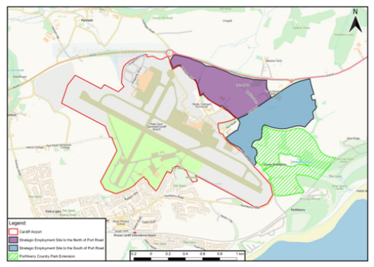
Figure 20: Cardiff Airport and Gateway Development Zone
Source: Cardiff Airport and Gateway Development Zone SPG (December 2019)
6.140 Land south of Port Road (Model Farm) Rhoose is currently subject to an appeal for non-determination of an outline planning application for a B1, B2, B8 Business. If the appeal is allowed, the site is anticipated to deliver 1.7 million sq. ft of Class B1, B2 and B8 offices, light industrial and warehousing and distribution units, alongside car parking, landscaping, drainage infrastructure and biodiversity enhancement works which include land for expansion of Porthkerry Country Park to the south (Figure 15). The site's proximity to Cardiff Airport and Bro Tathan alongside future aspirations of Cardiff and Vale College provides the opportunity to develop the area into a high-quality business cluster.
6.141 Bro Tathan East (St Athan) is located approximately 5 miles from Cardiff Airport, which together form the Welsh Government St Athan and Cardiff Airport Enterprise Zone. Since its designation in 2013 as one of 6 Enterprise Zones in Wales investment from the Welsh Government at Bro Tathan has provided some 1200 new jobs and has seen the refurbishment of the existing MOD hanger and buildings, the development of 32 ha of employment land (Bro Tathan North) and a new northern access road as well as improvements to the B4265. Bro Tathan is now home to a diverse range of businesses in high technology sectors including engineering/ technology research (Cardiff University), specialist drone manufacturer, cyber security start-up business and vertical farming.
6.142 The 48.5 ha of land allocated under SP13.3 relates to the next phase of investment at Bro Tathan East zone which the Welsh Government has indicated will be ready for development in 2025.Reflecting the Welsh Government's continued aspirations to develop the Bro Tathan East into a high-quality mixed use business park. The Council's ELS indicated an absence of ancillary facilities available to those employed at Bro Tathan, accordingly Policy SP13 allows for the provision of complimentary ancillary uses to support those employed at Bro Tathan.
6.143 In addition to the land allocated, Bro Tathan is identified as an existing employment area, which will enable further opportunities for employment uses to be developed over the longer term.
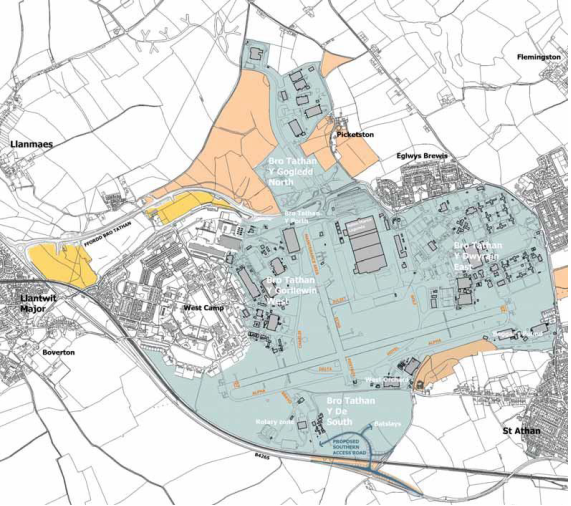
Figure 21: Bro Tathan
Source: Bro Tathan Y Porth Development Brief (July 2020)
6.144 Land South of Junction 34, M4 is occupied by Renishaw PLC, who acquired the site in 2011. Its strategic position adjoining the M4 motorway presents the Vale of Glamorgan with the opportunity for development of strategic scale industrial and logistics businesses. Outline planning consent was granted in 2016 for up to 151,060 sqm of Class B1, B2 and B8 uses; a Hotel/Residential Training Centre (Class C1/C2); and up to 1,300 sqm ancillary uses within Classes A1, A2, A3; alongside 30.5 ha of green infrastructure. The proposals (Figure 17) include the expansion of Renishaw existing manufacturing in the 40,000 sqm of warehousing (2019/01421/RES, approved May 2021), and a 6.64 ha business park which will contribute to meet identified local employment needs (SP13.8).
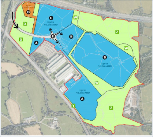
Figure 22: Future Land Uses Land South of Junction 34, M4
Source: Planning application 2019/01421/RES
Local Employment Allocations
6.145 Local employment allocations comprise a further 28.85 hectares (net) of land for B1, B2 and B8 uses and are allocated to ensure that an appropriate range and choice of land is available to support local economic growth. These sites are generally located within or adjoining existing employment areas that support a variety of employment uses, and provide opportunities for local small enterprises and start-ups, enable established business to expand and are attractive areas for local business investment.
6.146 The maintenance of a land bank of sites, particularly where growth sectors can be accommodated, is vital to the success of the areas' economic development initiatives and investment. Therefore, proposals for alternative uses on the strategic and local employment site allocations identified in Policy SP13 for non-employment purposes will not be permitted to protect their status as important employment sites.
Employment Regeneration Opportunity Areas
6.147 Policy SP13 identifies two Employment Regeneration Opportunity Areas at the Former Aberthaw Power Station and the Operational Port of Barry Docks, which the plan considers as important areas for supporting the LDP objectives for Climate Change and Greening the Vale's economy, facilitating the growth in renewable and low carbon energy production and businesses.
6.148 Aberthaw Power Station has been acquired by the Cardiff Capital Region (CCR) following investment of £38.4million and will see the former power station transformed into a Green Energy Park, which may include:
- The production of renewable and green energy projects.
- Battery storage facility to support the green energy projects.
- A zero-carbon manufacturing cluster, including green hydrogen production facilities.
- A green energy innovation centre to promote innovation, growth, knowledge, and community interaction with the zero-carbon future of Wales, and
- A bio-diversity ecology park which will include a visitor centre, providing amenities to the local community.
6.149 A Masterplan is currently being prepared by CCR Energy to inform the future development. The first phase of redevelopment will involve the demolition of the power station and remediation works which is expected to begin in 2023 and will take several years to complete.
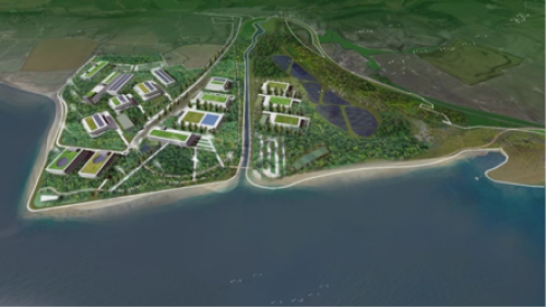
Figure 23: Aberthaw Green Energy Hub Concept Plan
6.150 Port facilities are an important regional infrastructure and economic asset within the South East Wales region and are acknowledged as such within Future Wales which states that "Local Development Plans should consider the role of the ports locally, regionally and nationally and establish frameworks to support their operation and potential expansion". In the Vale, Barry Docks provides a valuable source of local employment and has been the focus of regeneration for Barry with the redevelopment of Barry Waterfront for housing, retail, and recreation.
6.151 No2 Dock, Barry Docks which is owned by Associate British Ports (ABP) represents the second stage in the regeneration of Barry Docks which shall focus on enhancing the docks' economic role for the future. The identification of the area as an Employment Regeneration Area is reflects vision and aspirations of ABP contained within its long-term strategy Future Ports: Barry which sets out its employment areas and operational port land at No2 Dock to 2035, which focuses on developing the port around low and zero carbon sectors alongside traditional marine related industrial uses.
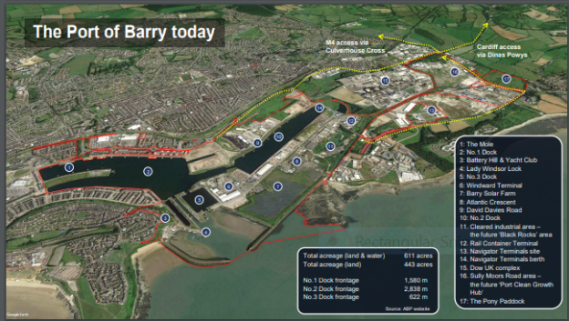
Figure 24: Future Ports: Barry Docks Land Use Proposals
Source: https://www.abports.co.uk/media/up4dk5s3/20220726-abp-barry-port-vision-v1-1-web-format.pdf
6.152 Potential projects identified within the proposals include redevelopment of existing industrial areas within the operational port for low carbon energy cluster including green energy production, carbon capture facilities and hydrogen production, as well as enhance road and rail access. To adapt to climate change, new development in the port will also need to incorporate necessary measures to address flood risk.
6.153 It is hoped that the growth in the renewables sector at Aberthaw and Barry Docks will create new highly skilled jobs and significantly boost the economy. Accordingly, Policy SP13 supports the growth of these sectors alongside B1, B2 and B8 employment.
TOURISM
6.154 The Vale's coastal and rural setting, along with its rich culture and historic environment are valuable assets for tourism and leisure. Attractions such as the Glamorgan Heritage Coast, Whitmore Bay, Barry Island and Penarth, as well as its location within the South East Wales region make the Vale of Glamorgan an attractive destination for day visitors, as well as those wishing to stay for longer.
6.155 The Vale's tourism assets provide a valuable source of local employment, employing over 2,000 people and generating some £203 million of visitor expenditure both directly and indirectly.
Proposals which promote the Vale of Glamorgan as a destination for Sustainable Tourism will be favoured. Development proposals should contribute to the positive image of the Vale as an attractive and sustainable tourist destination by:
A. Promoting opportunities for visitors to engage in forms of tourism that have a low impact on the environment.
B. Protecting and enhancing existing tourism attractions and leisure facilities;
C. Enhancing the visitor economy, attracting local investment, providing local employment opportunities and contributing to rural diversification.
D. Recognising and protecting the Vale's distinct local identity, built and natural environment as assets to tourism;
E. Providing a variety of tourism opportunities, particularly through all year-round facilities and a range of appropriately located visitor accommodation.
6.156 Policy SP14 seeks to support the provision of new and enhanced tourism facilities, whilst emphasising the importance for this to be undertaken in a sustainable manner, so that the natural and built tourism assets are maintained for the enjoyment of future generations. The RLDP will provide a policy framework which encourages new investment in appropriately located tourism, leisure and recreation facilities, and seeks to protect and enhance existing facilities, for the benefit of residents, visitors and the local economy.
CLIMATE CHANGE
SP15: CLIMATE CHANGE MITIGATION AND ADAPTATION
All development proposals must respond to the challenges of climate change by both mitigating its causes and adapting to its impacts.
The causes of climate change will be mitigated by ensuring new development proposals:
A. Contribute to decarbonisation in their siting, design, construction, mixture of uses and, by following placemaking principles.
B. Promote the principles of a circular economy by prioritising the reuse of existing buildings and the construction of more adaptable and durable buildings.
C. Maximise resource efficiency and sustainable construction techniques, including sourcing materials locally.
D. Include sustainable building design principles, incorporating passive building techniques where possible.
E. Maximise the opportunities for carbon sequestration from green infrastructure.
F. Maximise the opportunities for renewable energy development, specifically in local search areas, to provide 70% of projected electricity demand by 2036.
G. Promote the optimisation of energy supply and distribution options, including the provision of district heat networks.
New development proposals will adapt to the impacts of climate change by:
H. Being designed to respond to a warmer climate.
I. Promoting urban shading and cooling through the provision of green infrastructure.
J. Maximising water efficiency and minimise adverse impacts upon quality of water resource.
K. Redirecting development away from areas of flood risk and ensure that new development suitably controls surface water run-off through the use of sustainable drainage systems and nature-based solutions.
L. Redirecting development away from areas of coastal erosion.
All applications must set out how they mitigate the causes of climate change and adapt to its impacts.
Major Developments will be required to be accompanied by Energy Reports to display compliance with criterion D. Where it is proposed to demolish an existing building instead of reusing it, Whole Life Carbon Assessments will be required to ensure compliance with criterion B.
6.157 The planning process in isolation cannot respond to the implications of climate change and the declared Climate Emergency, and there is a role to play for all sectors of society. However, it is imperative that outcomes of the process respond to these implications where possible. Policy SP14 seeks to achieve this by ensuring that new development mitigates the causes of climate change and adapts to its implications. Specifically, the causes will be mitigated by sensitively considering new development through placemaking processes and seeking to reduce emissions both directly and indirectly. Impacts will be adapted to by considering the implications of a warmer climate. This will require specific consideration in the design of schemes to consider whether they are appropriate given greater fluctuation in weather patterns, including more extreme weather events, as well as rising sea levels.
6.158 Policy SP14 covers the principal areas where the planning process can mitigate the causes and adapt to the impacts of climate change. Responses to the implications are, however, wide ranging and cover multiple planning fields, for example, green infrastructure, sustainable transport, and placemaking. Therefore, whilst SP14 covers key issues at a high level, further detail is provided throughout the Strategic Policies to ensure that the appropriate level of attention is afforded to issues associated with climate change. This is specifically the case in relation to promoting modal shift and siting new development in locations that will reduce the need to travel, which is integral to achieving the Strategy and reducing emissions from transport. Issues dealt with explicitly by Policy 14 are expanded upon below.
6.159 New development will have to consider whether there are opportunities for achieving higher sustainable building standards, including zero carbon, to respond to the implications of climate change. This means:
- Mitigation: Ensuring the design and construction of new buildings minimises carbon emissions, including through taking measures to reduce energy consumption; and
- Adaptation: Ensuring buildings are resilient to projected changes to weather patterns, including more extreme weather events. This would include flood resilience and considering overheating.
6.160 Criterion B prioritises the reuse of existing buildings in order to account for their embedded carbon. However, it is recognised that this is not always the most effective means of limiting carbon emissions, especially where a new building could have significantly greater sustainability credentials. Therefore, Whole Life Carbon Assessments[8] can justify when it may be more appropriate to replace a building based by evidencing where less carbon may be emitted by replacing a building.
6.161 The Council is currently undertaking feasibility work to consider the implications of requiring new buildings to be zero carbon in their construction and operation. Once this is complete, the Council will be able to fully consider the economic viability impacts of requiring new buildings to be zero carbon in their construction and operation. In accordance with paragraph 5.8.5 of Planning Policy Wales, this work would provide the Council with robust evidence allowing us to bring forward standards higher than the national standards set out in Building Regulations. If this intervention were considered feasible, Policy SP14 would be updated at Deposit stage to reflect zero carbon requirements, and prescriptive supporting policy would be produced.
6.162 Policy 17 of Future Wales sets out that significant weight needs to be given to the need to generate 70% of Wales' electricity by 2030 from renewable sources, as well as other international commitments. A renewable energy assessment has been completed to identify how the Vale of Glamorgan can contribute to achieving this. The renewable energy assessment includes an identification of specific areas of search in the Vale of Glamorgan, where renewable energy development is least constrained. Further detailed policy will refer directly to the particulars of these specific areas. Having identified these areas and assessed the resource potential of the Vale of Glamorgan, a challenging but achievable target for renewable electricity energy production has been drawn up, as set out in the policy text. The feasibility of a heat network in Barry has also been considered, and the provision of this, as well as other sources of renewable heat energy, are facilitated by Policy SP15. Alongside local and regional partners a Local Area Energy Plan is being produced for the Vale of Glamorgan. This will identify pathways for decarbonising our energy system in line with national targets. The evidence produced from this work will inform the Deposit Plan and contribute to policy within it.
6.163 Areas within the Vale are at risk from flooding from both sea and rivers, and a Strategic Flood Consequences analysis has been carried out in collaboration with the other 10 south east Wales Local Authorities to consider this. Development proposals will have to ensure compliance with TAN15, to ensure development does not take place in locations with unacceptable flood risk. The Flood Map for Planning (FMfP) should be used as a material consideration to consider flood risk, and an updated TAN15 is expected to be published to accompany the FMfP in late 2023.
6.164 Predominantly, the flood risk from rivers is confined to rural areas. However, flood risk does exist to differing extents in Cowbridge, Dinas Powys and eastern Barry. Only some of these areas benefit from being within TAN15 Defended Zones, and there are other areas with no significant protection. From the sea, where flood risk exists in residential areas, namely Barry and Penarth Marina, these are included within TAN15 Defended Zones. Barry Docks and Aberthaw Power Station are at risk from tidal flooding and are not located within TAN15 Defended Zones. Therefore, further consideration will have to be given to the implications of flooding in these locations for development to be acceptable.
6.165 The southern coast of the Vale is susceptible to varying degrees of coastal erosion. Given this, varying policy approaches are recommended in the relevant Shoreline Management Plans[9][10] dependent on whether a coastline abuts rural or urban land, and the context of the risk. Where development is proposed in proximity Erosion Risk Map[11], relevant Shoreline Management Plans12and the Area Statement[12] for South Wales Central. Development should be avoided where there is a risk of it being affected by coastal erosion over its lifetime.
6.166 As set out in paragraph 5.8.4 of PPW, an Energy Report 'should include recommendations to the developer relating to energy efficiency and appropriate renewable energy technologies that could be incorporated into the development.' Future applications should also be accompanied by responses to these reports from the developer. The preparation of Energy Reports for major developments will assist in setting out how proposed developments comply with the requirements of Policy SP15 and respond to the implications of climate change.
SUSTAINABLE WASTE MANAGEMENT
6.167 The major streams of waste arising in the borough include municipal or local authority collected (including household); commercial and industrial; construction, excavation, and demolition; and hazardous. Waste management has changed significantly over the last twenty years in Wales with a major decrease in waste being disposed of to landfill and an increase in recycling.
SP16: SUSTAINABLE WASTE MANAGEMENT
The sustainable management of waste will be facilitated by:
A. Promoting and supporting additional sustainable waste management facilities, measures, and strategies in accordance with the waste hierarchy and the principles of nearest appropriate installation and self-sufficiency.
B. Supporting the circular economy by encouraging the minimisation of the production of waste and the use of reused and recycled materials in the design, construction, and demolition stages of development.
C. Ensuring that provision is made for the sustainable management, sorting, storage and collection of waste in all new developments.
The following locations are considered suitable for the development of in-building waste management solutions:
- Atlantic Trading Estate.
- The Operational Port of Barry Docks.
- Llandow Trading Estate.
- On suitable existing and allocated B2 and B8 industrial sites.
The provision of open-air sustainable waste management facilities on appropriate Class B2 or B8 industrial sites, operational mineral working sites, derelict land or buildings or within or adjoining existing farm complexes will also be acceptable where they do not conflict with existing or proposed neighbouring uses.
6.168 In line with the national waste strategy 'Towards Zero Waste', the Council will consider proposals in accordance with a 'waste hierarchy,' which ranks waste prevention and management options based on what is best for the environment. The highest priority in the hierarchy is the prevention of waste in the first place. Following this, if waste is created, priority should be given first to preparing it for re-use, then recycling, then other recovery (e.g., energy), and last of all disposal (e.g. landfill or incineration without energy recovery).
6.169 Technical Advice Note (TAN) 21 on Waste indicates that consideration should be given to how proposals for waste covered by Article 16 of the revised Waste Framework Directive fit with the 'nearest appropriate installation' principle. This approach requires that waste should be disposed of or recovered in appropriate facilities close to where it arises to reduce the detrimental environmental impacts associated with the transportation of waste. The provision of an integrated and adequate network of waste management facilities in the Vale and the wider region is critical to this and to ensuring self-sufficiency.
6.170 Consideration must also be given to the circular economy within the context of new development, which aims to keep materials, products and components in use for as long as possible. This approach facilitates cost savings and accords with the waste hierarchy by reusing, repairing and recycling materials.
6.171 Future Wales identifies waste as a policy area that requires a coordinated approach as part of the Strategic Development Plan (SDP) and consideration will be given to any emerging regional evidence as part of the plan preparation process. TAN 21 acknowledges that the Collections, Infrastructure and Markets Sector Plan provides a strategic assessment of waste, but monitoring will be required on a regional basis. The most recent Waste Planning Monitoring Report for South East Wales (April 2016) concludes that there is currently no need for additional landfill capacity within the region. In addition, the report advises that any new proposals for further residential waste treatment should be carefully assessed to ensure that overprovision does not occur within the region. As such, no specific need for new waste management facilities has currently been identified at a regional level.
6.172 As the Waste Planning Authority, the Council has a statutory responsibility for the collecting and disposing of municipal (household) waste and for land use planning control over waste management. The Vale is a member of Project Gwrydd, a partnership with four other local authorities (Caerphilly, Cardiff, Monmouthshire, and Newport) which have a long-term contract with Viridor Waste Management to treat residual municipal waste at the Trident Park energy from waste facility in Cardiff. There are two Household Waste Recycling Centres (HWRC) in the Vale located at the Atlantic Trading Estate in Barry and at the Llandow Trading Estate in Llandow.
6.173 Atlantic and Llandow Trading Estates, as well as the operational port of Barry Docks, are considered appropriate locations for in-building waste management facilities. Atlantic Trading Estate has seen the recent development of a resource recovery facility, as well as a reuse shop on land adjacent to the existing HWRC. In accordance with the Vale of Glamorgan Recycling and Waste Management Strategy (2022-2032), there are proposals to replace the existing HWRC at Llandow with a new modern facility as well as develop a second reuse shop.
6.174 To provide further flexibility, the policy also identifies existing Class B2 'general industrial' and B8 'storage and distribution' employment sites, as being potentially suitable locations for additional in-building waste management facilities.
6.175 For open air facilities, the LDP seeks to facilitate their provision through the Policy by identifying suitable locations where such facilities may be acceptable and would not conflict with neighbouring uses.
6.176 Planning applications for waste management facilities will be considered against national planning policy and guidance and other relevant LDP Policies.
MINERALS
6.177 National planning requires local planning authorities to make provision for a minimum land bank of 10 years for crushed rock and 7 years for land-based sand and gravel throughout the full 15 years of a development plan period, and to promote the sustainable manage of aggregates.
SP17: SUSTAINABLE PROVISION OF MINERALS
The local and regional need for the provision of a continuous supply of minerals will be achieved through:
A. Maintaining a minimum of 10 years land bank of crushed rock throughout the plan period.
B. Favouring proposals which promote the sustainable use of minerals and encourage the use of secondary and alternative resources.
C. The safeguarding of known resources of sandstone, limestone, sand and gravel (where these occur outside settlements), from permanent development that would unnecessarily sterilise them or hinder their future extraction; and
D. Safeguarding railheads to allow for the potential transportation of minerals by sustainable means and wharf facilities for the landing of marine dredged sand & gravel where appropriate.
6.178 The 2nd Review of the Minerals Regional Technical Statement for the South Wales area was published by the South Wales Regional Aggregates Working Party (SWRAWP) in September 2020. Appendix B of the RTS includes specific recommendations and guidance for each Local Planning Authority. The RTS 2nd review was subsequently amended by a policy clarification letter in November 2021, which indicates that the apportionment for the Vale of Glamorgan is 17.05 million tonnes of crushed rock over 25 years. There is an existing landbank of 18.73 million tonnes of crushed rock (as at 31st December 2016), all of which relates to Carboniferous Limestone. There is no apportionment and no land bank for land-won sand and gravel. The report concludes that in view of the slight surplus of existing permitted crushed rock reserves and the lack of sand and gravel production in the Vale of Glamorgan, no further allocations are specifically required to be identified within the RLDP.
6.179 The Vale of Glamorgan forms part of the Cardiff City sub-region along with Bridgend, Cardiff, Rhondda Cynon Taf, Merthyr Tydfil, Caerphilly and the Brecon Beacons National Park. The latest position statement for this sub-region (July 2022) indicates that whilst most authorities in the region, including the Vale of Glamorgan, can meet their apportionment for crushed rock, there is a shortfall in two authorities. Options are currently being considered to address this, but the RTS2 indicates that where the shortfall cannot be addressed through new allocations or permissions, collaborative working with neighbouring authorities in the same sub-region would be required in order to transfer the required provision to other LPAs. This position will be updated in the Deposit Plan.
6.180 Although the Wharf at Barry Docks has not been used for landing marine sand and gravel since 2005 it is recognised that this is a potential supply route of sand and gravel resource into the region. The wharf site is therefore safeguarded on the Proposals Map and future proposals will need to consider the potential impact on the landing of marine sand and gravel at Barry Docks. The safeguarding of the wharf does not prevent its use to land other goods and does not affect permitted development rights.Railheads should also be safeguarded in order to provide a full range of sustainable transport options.
DISTINCTIVE AND NATURAL PLACES
GREEN INFRASTRUCTURE
6.181 Green infrastructure is a network of multi-functional green spaces, urban and rural, which can deliver a wide range of environmental and quality of life benefits for local communities. Green infrastructure has a potentially important role to play in mitigating the impacts of extreme weather events, particularly extended heat waves. In addition, green infrastructure helps support biodiversity and makes an important contribution to the quality of the environment. Access to beautiful and well-maintained green spaces such as parks and gardens, country parks and wildlife areas, supports both physical and mental health and well-being.
Development proposals will incorporate measures that protect and enhance high quality green infrastructure provision and maximise its functionality. To achieve this, development proposals must:
A. Strategically incorporate existing green infrastructure into design, taking advantage of opportunities that are presented by existing and potential assets, through following the principles of placemaking.
B. Protect and enhance connectivity between green infrastructure assets.
C. Achieve biodiversity net benefit.
D. Protect landscapes designated for their geological, natural, visual, historic or cultural significance.
E. Employ nature-based solutions, including the Building with Nature Standards, where possible.
F. Provide amenity open space, which fulfils a wide range of roles.
G. Facilitate environments that promote mental and physical health and well-being.
H. Promote urban cooling and shading, sustainable drainage systems, and allotments and community orchards.
6.182 The wide variety of natural landscapes, biodiversity habitats, green spaces, coastal and rural areas alongside the network of footpaths and bridleways within the area is considered as one of the reasons why the Vale is such an attractive place to live and visit.
6.183 Ensuring the enhancement of biodiversity, the resilience of ecosystems, and maximising green infrastructure provision are crucial in responding to both the declared Climate and Nature Emergencies. Policy SP17 seeks to achieve this by identifying where development proposals should protect, enhance, and maintain existing green infrastructure. It also seeks to ensure that green infrastructure provision is holistic and delivers the benefits of a wide range of functions.
6.184 A Green Infrastructure Assessment has been completed to facilitate a robust and proactive approach to enhancing biodiversity, increasing ecological resilience and improving well-being outcomes. This identifies key strategic opportunities where the restoration, maintenance, creation and connection of green features and functions deliver the most significant benefits. The Green Infrastructure Assessment will inform the master planning of sites allocated in the Replacement Local Development Plan, as part of the placemaking of these sites.
6.185 This policy should be read alongside SP19 on Biodiversity and Ecosystem Resilience, which seeks to protect and promote connectivity. This will be achieved by retaining existing wildlife corridors and facilitating new linkages by taking advantage of site-specific opportunities. In attempting to identify opportunities, a site and its surrounding context should be considered. The site should also be considered in the context of the Green Infrastructure Assessment.
6.186 Delivering multifunctional green space is integral to delivering holistic green infrastructure and the intent of SP17 and the Green Infrastructure Assessment. Provision of multi-functional green infrastructure should create cohesive spaces that: allow for recreation and relaxation; promote physical and mental health and well-being; facilitate learning opportunities; support connectivity and wildlife habitat; manage water resources; mitigate and adapt to climate change; enhance local food production; and support heritage and culture. It can also play a major role in attracting economic growth and investment, increasing land and property benefits, promoting tourism, and increasing business productivity.
6.187 Nature based solutions can be a valuable tool in creating sustainable and resilient developments. Incorporating features such as SUDS, tree planting and accessible natural green spaces, can make a significant contribution to providing green infrastructure, supporting biodiversity, mitigating the effects of climate change and contributing to the creation of more liveable and sustainable communities. The Building with Nature Standards (BwN 2.0) provides a framework of best practice Standards that collectively defines a benchmark of good green infrastructure and how to deliver it. These standards provide a benchmark of good practice and should be applied to all development as a quality checklist, in a way which is proportionate to the nature and scale of the development proposed.
6.188 In delivering new and enhanced green infrastructure it is vital to co-ordinate infrastructure provision so that resources are used effectively. The Council'is currently preparing a Green Infrastructure Plan, which will set out the green infrastructure assets and the various partners involved in green space provision. It will contain a vision, background evidence, recommendations, and an action plan.
6.189 Development will be directed away from areas identified as having high ecological value, and these will be limits to where growth can take place in the Vale of Glamorgan. Green infrastructure and particularly areas of high ecological value should not be viewed solely as limits that constrain growth. Instead, it should be viewed as an infrastructure asset that can undergo growth itself, with the purpose of accelerating nature recovery. This will be achieved by taking advantage of the opportunities presented by existing green infrastructure and seeking to influence landowners to strategically manage it with improved provision in mind. The areas of high ecological value identified in the Replacement LDP will form the basis of this and land in proximity to these should be prioritised for maximising provision, in line with the Strategy set out in the Council's Green Infrastructure Plan.
NATURE CONSERVATION AND BIODIVERSITY
6.190 The rich and varied biodiversity of the Vale of Glamorgan supports a wide range of wildlife habitats and species that are highly valued and contribute to the Vale's distinctive character and sense of place. These assets include sites and areas of European, national and local importance, as well as important landscapes, woodlands and an extensive coastline that includes the Vale of Glamorgan Heritage Coast.
SP19: BIODIVERSITY AND ECOSYSTEM RESILIENCE
Biodiversity in the Vale of Glamorgan will be protected, maintained and enhanced. Development must provide a net benefit for biodiversity and improve the resilience and connectivity of ecosystems. To achieve this, all developments must:
A. Demonstrate that there has been an overall net benefit for biodiversity proportionate to the nature and scale of the development.
B. Ensure that UK/European protected species and habitats are protected in accordance with statutory requirements.
C. Protect the integrity of statutory and non-statutory designated sites ensuring that they are properly protected and managed.
D. Be directed away from areas of high ecological value.
E. Incorporate green infrastructure at the early stages of design, that protects and enhances existing site features and improves the connectivity of the ecological network.
F. Incorporate nature-based solutions within development to support biodiversity and build ecosystem resilience within the site and the wider area.
Development on or adversely affecting other non-designated sites or wildlife corridors with biodiversity value will only be permitted where it can be demonstrated that the need for the development outweighs any harm caused by the development and that net biodiversity benefit measures can be provided.
6.191 Policy SP19 Biodiversity and Ecosystem Resilience recognises the importance of the Vale of Glamorgan's natural assets and seeks to ensure that they are protected, maintained and enhanced not only for their intrinsic nature conservation value, but also for the wider social, economic and community benefits that they provide.
6.192 The Environment (Wales) Act 2016 introduced an enhanced biodiversity and resilience of ecosystems duty (Section 6 Duty) on public authorities in Wales. This duty requires that in the exercise of their functions, public authorities in Wales must seek to maintain and enhance biodiversity by ensuring development does not cause any significant loss of habitats or populations of species and must provide a net benefit for biodiversity.
6.193 Development will therefore be required to demonstrate that a net benefit for biodiversity can be achieved. A net benefit for biodiversity can be achieved through a range of actions ranging from habitat creation and/or long-term management arrangements that enhance existing degraded habitats and improve the resilience of ecosystems. Benefits must be long term, measurable, demonstrable, and primarily on site. Biodiversity enhancements should be delivered following the step-wise approach of firstly avoiding, then minimising, with mitigation as a last resort for compensating any negative impact. Where it is not possible to achieve on-site mitigation and enhancement, off-site compensation must be provided to ensure a biodiversity net benefit.
6.194 Networks of natural habitats and green infrastructure provide a valuable ecological resource. They connect sites of biodiversity importance and provide stepping stones for the migration, dispersal and genetic exchange of species within the wider environment. To avoid fragmentation and isolation of natural habitats, such networks should be protected from inappropriate development and where possible enhanced. The Council's Green Infrastructure Assessment identifies the green infrastructure provision within the Vale of Glamorgan and contains a vision, recommendations, and action plan of how green infrastructure within the Vale can be extended and enhanced.
6.195 Sensitive design and choice of location of new development can have a positive effect on the Vale's built and natural heritage. Similarly, new development will be required to minimise its impact on natural systems, landscapes, species and habitats and where appropriate provide opportunities for the creation of new habitats or the sensitive enhancement of existing habitats.
6.196 Policy SP19 Biodiversity and Ecosystem Resilience is supported by SP11 Community Infrastructure and Planning Obligations and SP17 Green Infrastructure. These require new development to provide new community infrastructure including Green Infrastructure and features that support biodiversity enhancement and to incorporate Green Infrastructure respectively.
QUESTION 9: STRATEGIC POLICIES
The strategic policies in the Preferred Strategy form the framework for implementing and delivering the identified objectives. Do you agree with the strategic policies? (please state which strategic policy your comments relate to)
QUESTION 10: FURTHER COMMENTS
Do you have any additional comments that you would wish to make of the Preferred Strategy or the supporting documentation?
QUESTION 11
We would like to know your views on the effects that these proposals would have on the Welsh language, specifically on opportunities for people to use Welsh and on treating the Welsh language no less favourably than English. What effects do you think there would be? How could positive effects be increased, or negative effects be mitigated?
Appendix 1 – Existing Land Supply - Sites with planning permission including sites under construction – 1st April 2023
|
Settlement Tier |
Site Name & Planning Reference |
Source |
Total Site Capacity |
Dwellings not started April 2023 |
Dwellings Under Construction April 2023 |
|
Key Settlement: Barry |
Land known as East Quay, Barry Waterfront, Barry 2019/01393/RES (Taylor Wimpey) |
LDP Allocation (with PP) |
58 |
0 |
30 |
|
Key Settlement: Barry |
East Quay, (Land to West of Cory Way, South of the Graving Dock) 2019/01384/RES (Persimmon) |
LDP Allocation (with PP) |
62 |
0 |
62 |
|
Key Settlement: Barry |
Development land at East Quay, Barry Waterfront - 2019/01385/RES (Barratts) |
LDP Allocation (with PP) |
56 |
0 |
13 |
|
Key Settlement: Barry |
Development land at East Quay, Barry Waterfront (to East of Cory Way) 2019/01386/RES (United Welsh) |
LDP Allocation (with PP) |
36 |
0 |
36 |
|
Key Settlement: Barry |
Holm View (Phase1 11 dwellings Complete) Phase 2 31 dwellings application 2022/00397/REG3 (Vale of Glamorgan Council) |
LDP Allocation (with PP) |
42 |
31 |
0 |
|
Key Settlement: Barry |
Hayes Wood, The Bendricks 2021/00378/REG3 (Vale of Glamorgan Council) |
Windfall |
53 |
41 |
12 |
|
Key Settlement: Barry |
Colcot Health Clinic, Winston Road, Barry 2021/01444/RG3 Vale of Glamorgan Council |
Windfall |
12 |
0 |
12 |
|
Key Settlement: Barry |
81-85, Holton Road, Barry -former Dan Evans 2021/00622/FUL (Hafod) |
Windfall |
25 |
25 |
0 |
|
Key Settlement: Barry |
Castle Hotel, Jewel Street, Barry 2019/01062/FUL(Newydd) |
Windfall |
14 |
0 |
14 |
|
Key Settlement: Barry |
Sea View Labour Club, Dock View Road, Barry 2019/01061/FUL (Newydd) |
Windfall |
28 |
0 |
28 |
|
Key Settlement: Barry |
Former Windsor Hotel, Holton Road, Barry 2019/01060/FUL (Newydd) |
Windfall |
18 |
0 |
18 |
|
Key Settlement: Barry |
Haydock House, 1, Holton Road, Barry 2013/01249/FUL (Hafod) |
Windfall |
16 |
0 |
16 |
|
Key Settlement Barry |
Land at Coldbrook Road East, Cadoxton 2021/01743/FUL (Vale of Glamorgan Council) |
Windfall |
20 |
0 |
20 |
|
Key Settlement Barry |
Former Railway Sidings, Ffordd y Milleniwm, Barry 2020/00775/OUT Pending S106 (Hafod) |
Windfall |
56 |
56 |
0 |
|
Service Centre (Cowbridge) |
Cowbridge Comprehensive 6th Form Block, Aberthin Road 2018/01408/FUL Pending S106. (Hafod) |
LDP Allocation (with PP) |
34 |
34 |
0 |
|
Service Centre (Cowbridge) |
Land to the north and west of Darren Close, Cowbridge 2017/00841/RES – Phase 1 – 169 Units |
LDP Allocation (with PP) |
475 |
242 |
64 |
|
Service Centre (Llantwit Major) |
Land adjacent to Froglands Farm, Llantwit Major- Land North of West Camp - Site B - Eastern Parcel, Llanmaes 2020/00352/OUT Pending S106 (Welsh Ministers) |
LDP Allocation (with PP) |
90 |
90 |
0 |
|
Service Centre Llantwit Major) |
Phase 1 Land between new Northern Access Road and Eglwys Brewis Road- Land East of B4265 – Site B - Western Parcel, Llanmaes- 2020/00351/OUT- 140 dwellings approved Pending S106 (Welsh Ministers) |
LDP Allocation (with PP) |
140 |
140 |
0 |
|
Service Centre (Penarth) |
Land to the rear of Nos. 2 to 4, St. Cyres Road, Penarth 2020/01232/RG3 (Vale of Glamorgan Council) |
Windfall |
14 |
0 |
14 |
|
Service Centre (Penarth) |
56a, Windsor Road, Penarth (Former Monty Smith Ltd) 2018/01420/FUL (X-Stream Properties) |
Windfall |
21 |
0 |
21 |
|
Service Centre (Penarth) |
Land adjacent to Oak Court- Planning application 2022/00294/HYB 70 bed extra care and 32 older person accommodation Pending S106 (Wales and West) |
LDP Allocation (with PP) |
102 |
102 |
0 |
|
Primary Settlement (Llandough) |
Land south of Llandough Hill / Penarth Road Application 2020/01590/HYB Pending S106 |
LDP Allocation (with PP) |
133 |
133 |
0 |
|
Primary Settlement (Llandough) |
Land north of Leckwith Road 2018/01023/FUL (Hafod) |
LDP Allocation (with PP) |
40 |
0 |
40 |
|
Primary Settlement (St Athan) |
Land to the east of Eglwys Brewis (Land off Cowbridge Road) 2019/01408/RES (Barratt David Wilson) |
LDP Allocation (with PP) |
253 |
72 |
80 |
|
Primary Settlement (St Athan) |
Land off Gileston Road, St. Athan 2017/01263/FUL |
Windfall |
18 |
18 |
0 |
|
Primary Settlement (St Athan) |
St. Athan Boys Village, St. Athan Application 2022/00452/RES (JS Construction) |
Windfall |
15 |
15 |
0 |
|
Primary Settlement (Rhoose) |
Land to the North of Heol Y Pentir, Rhoose 2022/00602/RES (Wales and West) |
Windfall |
15 |
15 |
0 |
|
Primary Settlement (Sully) |
Phase 1: Land West of Swanbridge Road, Sully (Taylor Wimpey) |
LDP Allocation (with PP) |
325 |
118 |
25 |
|
Primary Settlement (Sully) |
Phase 2: Land West of Swanbridge Road, Sully. Application 2016/01520 (Taylor Wimpey) |
LDP Allocation (with PP) |
190 |
190 |
0 |
|
Minor Rural Settlement (Bonvilston) |
Land to the east of Bonvilston, Application 2015/00960/FUL (Acorn) |
LDP Allocation (with PP) |
120 |
72 |
8 |
|
Minor Rural Settlement (Southerndown) |
Dunraven Court, Beach Road, Southerndown 2019/00503/FUL |
Windfall |
22 |
22 |
0 |
|
Minor Rural - Wick |
Land at St. Brides Road, Wick 2021/01081/FUL (Wales and West) |
Windfall |
17 |
17 |
0 |
|
Other Rural (Hensol) |
Hensol Castle, Hensol Castle Park, Hensol 2018/00482/HYB |
Windfall |
16 |
16 |
0 |
|
2,536 |
1,449 |
513 |
|||
|
Total Dwellings April 2023 |
1,962 |
||||
Appendix 2 – Rolled Forward adopted LDP Sites
|
Settlement Tier |
Allocated Site Name |
Status |
Total Site Capacity at April 2023 |
|
Key Settlement (Barry) |
Land to the west of Pencoedtre Lane |
No current planning application - Site part of Council's Housing Programme |
135 |
|
Service Centre (Llantwit Major) |
Former Eagleswell Primary School |
No current planning application - Site part of Council's Housing Delivery Programme |
72 |
|
Service Centre (Llantwit Major) |
Land between new Northern Access Road and Eglwys Brewis Road (east) |
No current planning application - Candidate Site Submission |
185 |
|
Service Centre (Cowbridge) |
Land adjoining St. Athan Road, Cowbridge - Land between Windmill Lane and St Athan Road, Cowbridge |
2022/00958/FUL planning application awaiting determination |
105 |
|
Service Centre (Penarth) |
Land at Upper Cosmeston Farm, Lavernock, |
2020/01170/OUT planning application awaiting determination |
576 |
|
Primary Settlement (St Athan) |
Land at Church Farm, St. Athan - No Current Application |
No current planning application - Candidate Site Submission |
250 |
|
Primary Settlement (St Athan) |
Former Stadium Site / Land adjacent to Burley Place, St. Athan – Developer interest |
No current planning application – Developer interest |
80 |
|
Primary Settlement (St Athan) |
Land at Higher End St Athan (Phase 2) |
2022/00266/RES - 25 Affordable Dwellings -planning application awaiting determination |
25 |
|
Primary Settlement (Rhoose) |
Land north of the Railway Line, Rhoose (East). |
Application 2022/00733/FUL submitted June 2022- planning application awaiting determination |
282 |
|
TOTAL |
1,710 |
Appendix 3 – Key Housing Sites
Key Settlement – Barry
A3.1 During the adopted LDP period, a significant proportion of new housing and accompanying facilities proposed for Barry have been developed on the large brownfield regeneration site at Barry Waterfront, which was identified as a mixed-use strategic site in the LDP. The housing part of this scheme is now nearing completion, although there remain development opportunities on the Waterfront for other uses, including land identified for a potential college campus.
A3.2 An Urban Capacity Study (UCS) has been prepared to consider potential development sites within the existing defined settlement of Barry. The UCS has demonstrated that there are no other sites suitable for housing likely to become available on previously developed land of a similar scale to the Waterfront, although there are a number of infill and redevelopment opportunities that may be acceptable in principle as windfall sites over the RLDP plan period. It is therefore the case that for Barry to accommodate a level of growth commensurate with its position as a Key Settlement in the settlement hierarchy (as identified in the Settlements Appraisal Review Background Paper) it will be necessary to consider a sustainable extension to the settlement.
A3.3 The Spatial Options Background Paper identifies that Barry is constrained by flooding to the south of the town, landscape constraints to the north, and Best and Most Versatile (BMV) agricultural land to the east. Having regard to these constraints, opportunities for sustainable growth beyond the existing settlement boundaries of the town are limited.
A3.4 Through the candidate site assessment process, a key site has been identified to the North East of Barry (SP4 KS1) on an area of primarily low agricultural land. The 71.1 Ha site could accommodate up to 1,500 dwellings, although it is anticipated that only 900 dwellings would be anticipated to be delivered within the RLDP plan period up to 2036. There would be a requirement for a minimum of 30% affordable housing (300 units), with the site making an important contribution in delivering affordable housing in one of the areas with the highest need.
A3.5 In line with the sustainable growth strategy, a development of the scale proposed in this location in North East Barry would allow new housing to be aligned with employment, services and facilities to reduce the need to travel. The proposed site would encompass a range of uses including a primary school and a new village centre with uses such as cafes, retail and workshops/co-working units. A gateway building is also proposed at the entrance to the site, which could incorporate a mix of uses that not only serve the site but also the adjoining Pencoedtre Village Estate. In addition to the mix of uses on site, a supermarket is already located at the entrance and a secondary school is located directly south. Further consideration will need to be given to what is a viable and appropriate scope and mix of non-residential uses.
A3.6 Another key element of the strategy is to focus development in locations that are well served by existing and proposed rail stations and in areas with good bus links. Barry is well served by the rail network with four stations and 4 services an hour to Cardiff. Travel time isochrone maps prepared by Transport for Wales indicate that this site is currently within a 15-minute cycle of Cadoxton station and the southern-most part of the site is within a 20-minute walk.
A3.7 It is recognised that the site is adjacent to the A4231 Barry Docks Link Road. However, there will be a requirement for the delivery of significant Active Travel improvements to enhance connectivity with the surrounding area. This would include the provision of a pedestrian and cycle lane on the A4321, linking to both the existing Active Travel route along Port Road to the north and the Cardiff Road roundabout to the south. Such an improvement would offer significant benefits in the provision of Active Travel routes serving the town and wider AT network. Furthermore, there are proposed improvements to provide safe pedestrian and cycle routes from the site to Cadoxton station through the existing residential area, and at the station itself where secure cycle parking and improved pedestrian access into the is proposed.
A3.8 Highway improvements associated with the development of the site would include the removal of the roundabout at the site entrance (Gilbert Lane) and its replacement with a signalised junction with prioritised cyclist and pedestrian crossings, which will improve connectivity with the housing estate opposite by sustainable modes of travel. In addition, a bus loop is proposed to serve the site, linking to existing services in Barry where feasible.
A3.9 The site adjoins two areas of Sites of Special Scientific Interest (SSSI) at Barry Woodlands. The SSSIs will be protected through appropriate buffering. A specific opportunity exists to enhance ecological connectivity between the currently divorced parcels of the Barry Woodlands SSSI, to the north of the site. The south of the site is primarily wetlands and this provides a significant opportunity for multifunctional green infrastructure, including water management, biodiversity enhancements and engaging public amenity space. In addition, the site will need to provide multi-functional green infrastructure, including playing fields.
A3.10 A context plan has been included at Figure A1 and a high-level initial illustrative layout is set out in Figure 13. This will be refined through the masterplanning process and at Deposit stage further detail including the key placemaking principles for each site will be defined.
Figure A1 Land at North East Barry Context Plan
Service Centre Settlements – Cowbridge, Penarth, Llantwit Major
A3.11 The settlements of Cowbridge, Penarth and Llantwit Major have all been identified as service centre settlements, informed by the Settlement Appraisal Review, reflecting their role in providing a range of services that provide for the daily needs of their residents and acting as important hubs for those living in nearby smaller settlements. Penarth and Llantwit Major are well served by the rail network, with Penarth having 3 stations (Penarth, Dingle Road and Cogan). Cowbridge does not have a station but has good bus connectivity with Cardiff and Bridgend and is considered to be a highly sustainable settlement with a range of services and facilities.
A3.12 Each of the Service Centre Settlements have large adopted LDP allocations that are either under construction or are realistically likely to be developed within the RLDP plan period. In Cowbridge, the allocation at Darren Farm, comprising 475 dwellings, is currently under construction. The development is not due to be completed until several years into the plan period. This site, together with two other allocated housing sites in the town that are subject to planning applications or pending the signing of a Section 106 agreement, will provide the majority of the town's future market and affordable housing. As a result, it is not considered that the town requires any further larger 'key' allocations. Smaller scale developments in sustainable locations may be acceptable if a need for such uses is identified.
A3.13 The Upper Cosmeston Farm site in Penarth is key to the future growth of the settlement for market and affordable housing. The 576 dwelling allocated site is currently subject to a planning application and is considered realistically likely to be delivered. As the site is Welsh Government owned, it will deliver 50% affordable housing. In addition, there are several smaller schemes either with planning permission or under construction in Penarth. Due to its coastal location and other constraints, development opportunities are limited. The Urban Capacity Study considered potential sites in the Penarth area and whilst there are a number of sites that could potentially be brought forward as relatively small-scale windfall sites, there are no other significant opportunities within the town.
43.14 Land is allocated for housing between the northern access road and Eglwys Brewis Road, which would serve the Llantwit Major housing market. The site comprises three parcels, two of which have planning permission for housing, (pending s106) and the third is considered realistically likely to be delivered. Collectively, the three parcels would deliver 415 dwellings, which is a site commensurate to the role of the town of Llantwit Major.
Primary Settlements in the Strategic Growth Corridor
A3.15 The primary settlements of Dinas Powys, Rhoose, St Athan, Llandough (Penarth) and Sully are identified within the strategic growth area and are therefore areas where sustainable levels of development could be acceptable.
Dinas Powys
A3.16 Dinas Powys is the best served of the primary settlements in terms of the rail network with stations at Eastbrook and Dinas Powys, and Cogan station also within reasonable walking distance. The settlement scores highly in the Settlement Appraisal Review due to the number of services and facilities in the area.
A3.17 Land has been identified at a key site to the North of Dinas Powys (SP4 KS2). The site is 12.7 Ha and could accommodate up to 250 dwellings, with a minimum of 40% affordable housing.
A3.18 The site would accord with the strategy, as Transport for Wales maps show that Eastbrook station is at maximum a 10-minute walk from the site. It is also well related to services, facilities and employment opportunities, with primary schools, a GP surgery and local retail provision located in the village and Llandough Hospital in close proximity to the site. Access to the site would be off a new signalised junction from Cardiff Road, which will require the reconfiguration of the road to incorporate a waiting lane and improved Active Travel links. Active Travel links from the site to Eastbrook station, local schools and connections to facilities within Cardiff will be required.
A3.19 A multi-functional green infrastructure corridor is proposed through the north of the site and the allocation of this land would provide the opportunity to enhance existing and create new ecological habitats, which surround the site. The introduction of varying habitats would also be achieved through the provision of SuDS.
A3.20 A context plan has been included at Figure A2 and a high-level initial illustrative layout is set out in Figure 14. This will be refined through the masterplanning process.
Figure A2 Land to the North of Dinas Powys Context Plan
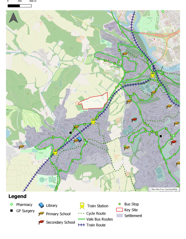
Rhoose
A3.21 The primary settlement of Rhoose is well positioned on the Vale of Glamorgan line with an existing station in a central location within the village, offering hourly (soon to be twice-hourly) connections to Barry, Cardiff and Bridgend.
A3.22 Rhoose has a number of facilities, including two primary schools and local retailing, and is also a location where housing could be aligned with existing and future employment opportunities, given the proximity of the site to Cardiff Airport and the Enterprise Zone, as well as the proposed Aberthaw Green Energy Park.
A3.23 A 450 dwelling scheme is identified on land at Readers Way on a 29.3 Ha site, with a minimum of 35% affordable housing. The site will be residential led with the potential for an element of mixed use. The site is currently within a 20-minute walk from the station and active travel links will be improved to connect the site to the wider area.
A3.24 It is recognised that the site is in close proximity to the airport runway so to mitigate against any amenity issues, the masterplan proposes housing on the western part of the site, with the eastern part wholly for green infrastructure improvements, providing an opportunity to achieve strong multifunctionality and connectivity. Indicatively, this includes the provision of space for food growing. Other small scale mixed uses are also identified.
A3.25 Readers Way Pond is a Site of Importance for Nature Conservation (SINC) is located 50 metres to the south of the site. Opportunities exist to improve connectivity from this feature to the improved green infrastructure provision along the eastern boundary of the site.
A3.26 A3.10 A context plan has been included at Figure A3 and a high-level initial illustrative layout is set out in Figure 15. This will be refined through the masterplanning process.
Figure A3 Land at Readers Way, Rhoose Context Plan
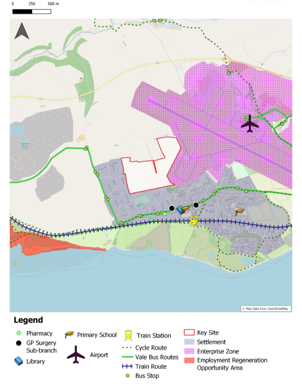
St Athan
A3.27 The adopted LDP identifies St Athan as a Strategic Opportunity Area, recognising the opportunities derived from the Bro Tathan Enterprise Zone and the development of the Northern Access Road alongside housing to support this role. Bro Tathan has successfully attracted a number of businesses providing employment, and several allocated housing sites have been brought forward.
A3.28 The RLDP strategy continues to seek to align housing and employment and with the development potential that remains at Bro Tathan, as well as the proposed Aberthaw Green Energy Park, St Athan remains a key part of the strategy.
A3.29 The Preferred Strategy also seeks to focus development around key sustainable transport nodes. A feasibility study for a station in St Athan has been undertaken, which identifies that a new station could be located in St Athan, subject to further investigation work. The allocation of two key sites in close proximity to the preferred site for a station would help support the business case by ensuring there is a sufficient critical mass of people living near the station to support its patronage.
A3.30 Two residential led sites have been identified as key sites in St Athan, reflecting its potential to align jobs and housing. Land at Church Farm (SP4 KS4) comprises land to the east of the settlement, which is allocated in the adopted LDP for housing, together with an adjoining parcel of land. Collectively, this 24.6 Ha site is anticipated to deliver between 250 and 550 dwellings. The site is proposed to be accessed of Gileston Road.
A3.31 The provision of a large area of green infrastructure in the south east of the site, provides a significant opportunity for multifunctionality and indicatively includes Active Travel connectivity from St. Athan to the access to the Aberthaw Green Energy Park site. Allocation of this site would provide the opportunity to enhance existing and create new habitats, which surround the site. The introduction of varying habitats would also be achieved through the provision of SuDS.
A3.32 The second key site is proposed at Land West of St Athan (SP4 KS5). This 28 Ha site is proposed for a residential led scheme. In addition, an additional parcel of land within the same ownership located to the east is identified as the preferred location for the proposed station, alongside a commercial use.
A3.33 The provision of sensitive landscaping to compliment the heritage assets to the north of the site is required. Allocation of this site would provide the opportunity to enhance existing and create new habitats, which surround the site. The provision of a large area of multi-functional green infrastructure in the north east of the site, including playing fields and Active Travel connectivity into St. Athan is required.
A3.34 Both sites will be required to deliver a minimum of 35% affordable housing. Consideration will also be given to how the provision of new sites in St Athan can contribute towards educational needs in the Western Vale area.
A3.35 Context plans have been included at Figure A4 and A5 and High-level initial indicative layouts are set out in Figure 16 and 17. These layouts will be refined through the masterplanning process.
Sully
A3.36 The adopted LDP allocates a significant housing site comprising 515 dwellings across two phases. Both phases have the benefit of planning permission and as of 1st April 2023, 308 units had not been started. The delivery of housing on this site will support Sully's role as a primary settlement.
Llandough (Penarth)
A3.37 Planning permission has recently been approved (pending s106) on a site between Llandough and Penarth and a further allocated site of 40 dwellings is currently under construction. These existing sites will support Llandough's role as a primary settlement.
Figure A4 Land at Church Farm, St Athan Context Plan
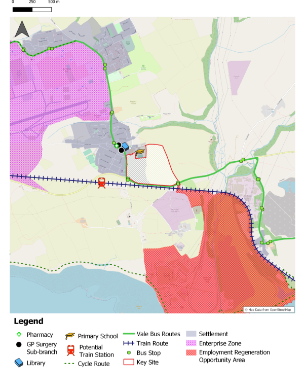
Figure A5 Land West of St Athan Context Plan
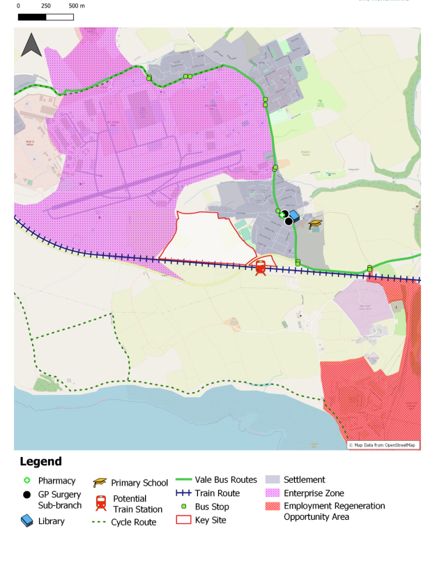
[7] WHIASU HIA guidance: HIA_Tool_Kit_V2_WEB-1.pdf (phwwhocc.co.uk)